![](/images/other/stat-length.png)
![Randonnée A pied Oberschlierbach - Brand - Photo](https://media.geolcdn.com/t/1900/400/ext.pjpeg?maxdim=2&url=https%3A%2F%2Fmedia.geolcdn.com%2Ff%2Fe36d2b50-75b4-41d2-a837-33cd8e9cc3e5.jpeg)
Brand
SityTrail - itinéraires balisés pédestres
Tous les sentiers balisés d’Europe PRO
![Longueur](/images/other/stat-length.png)
Longueur
6,5 km
![Altitude max](https://static1.geolcdn.com/siteimages/upload/files/1508320355ic_sort_altitude_max_24dp.png)
Altitude max
788 m
![Dénivelé positif](https://static1.geolcdn.com/siteimages/upload/files/1508320355ic_sort_den_pos_24dp.png)
Dénivelé positif
214 m
![Km-Effort](/images/other/stat-length.png)
Km-Effort
9,3 km
![Altitude min](https://static1.geolcdn.com/siteimages/upload/files/1508320355ic_sort_altitude_min_24dp.png)
Altitude min
604 m
![Dénivelé négatif](https://static1.geolcdn.com/siteimages/upload/files/1508320355ic_sort_den_neg_24dp.png)
Dénivelé négatif
208 m
![Boucle](https://static1.geolcdn.com/siteimages/upload/files/16400158638029165_repeat_loop_refresh_sync_direction_icon.png)
Boucle
Oui
Balise
Date de création :
2022-02-16 17:04:54.506
Dernière modification :
2022-03-03 16:13:52.593
![A pied](https://static1.geolcdn.com/sitytour/trail-icons/100.png)
2h06
Difficulté : Facile
![Scannez ce code QR pour ouvrir la randonnée dans l'application SityTrail](https://capi.geolives.com/qq0zvz2zws4bq2lad0pu/sitytour/trails/3128749/qr.png?size=200)
Application GPS de randonnée GRATUITE
À propos
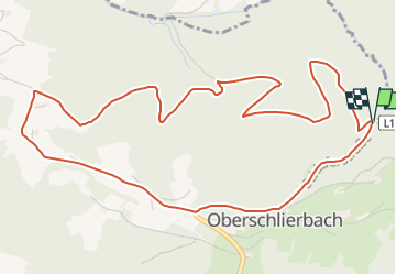
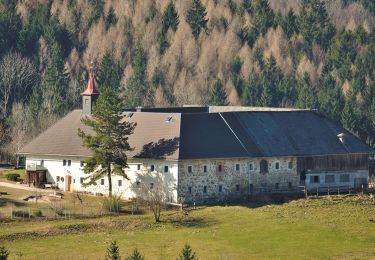
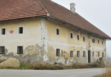
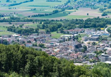
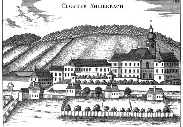
Randonnée A pied de 6,5 km à découvrir à Haute-Autriche, Bezirk Kirchdorf, Oberschlierbach. Cette randonnée est proposée par SityTrail - itinéraires balisés pédestres.
Description
Randonnée créée par Gemeinde Oberschlierbach.
Symbole: weiss-rot-weiss K71 oder gelber Hiweispfeil mit schwarzer Aufschrift Brand K71
Localisation
Pays :
Autriche
Région :
Haute-Autriche
Département/Province :
Bezirk Kirchdorf
Commune :
Oberschlierbach
Localité :
Unknown
Départ:(Dec)
Départ:(UTM)
439164 ; 5309914 (33T) N.
Commentaires
Randonnées à proximité
![Randonnée A pied Molln - Rinnende Mauer-Runde - Photo](https://media.geolcdn.com/t/375/260/ext.jpg?maxdim=2&url=https%3A%2F%2Fmedia.geolcdn.com%2Ff%2Fd745699b-f0f7-4730-9f09-488cc9ff57e4.jpeg)
![A pied A pied](https://static1.geolcdn.com/sitytour/trail-icons/100.png)
Rinnende Mauer-Runde
A pied
Facile
Molln,
Haute-Autriche,
Bezirk Kirchdorf,
Autriche
![](/images/other/stat-length.png)
4,9 km | 5,8 km-effort
1h 19min
![](https://static1.geolcdn.com/siteimages/upload/files/16400158638029165_repeat_loop_refresh_sync_direction_icon.png)
Oui
![Randonnée A pied Schlierbach - Dem Käse auf der Spur - Photo](https://media.geolcdn.com/t/375/260/ext.jpg?maxdim=2&url=https%3A%2F%2Fmedia.geolcdn.com%2Ff%2F4e49173f-29a8-473a-a38f-a4e64fdea13d.jpeg)
![A pied A pied](https://static1.geolcdn.com/sitytour/trail-icons/100.png)
Dem Käse auf der Spur
A pied
Facile
Schlierbach,
Haute-Autriche,
Bezirk Kirchdorf,
Autriche
![](/images/other/stat-length.png)
7,9 km | 13,8 km-effort
3h 8min
![](https://static1.geolcdn.com/siteimages/upload/files/16400158638029165_repeat_loop_refresh_sync_direction_icon.png)
Oui
![Randonnée A pied Kirchdorf an der Krems - Dem Schoko, Kaffee & Most auf der Spur - Photo](https://media.geolcdn.com/t/375/260/ext.jpg?maxdim=2&url=https%3A%2F%2Fmedia.geolcdn.com%2Ff%2F62a70541-0d0b-49d7-b4cc-ad3958e0a676.jpeg)
![A pied A pied](https://static1.geolcdn.com/sitytour/trail-icons/100.png)
Dem Schoko, Kaffee & Most auf der Spur
A pied
Facile
Kirchdorf an der Krems,
Haute-Autriche,
Bezirk Kirchdorf,
Autriche
![](/images/other/stat-length.png)
8,2 km | 9,5 km-effort
2h 9min
![](https://static1.geolcdn.com/siteimages/upload/files/16400158638029165_repeat_loop_refresh_sync_direction_icon.png)
Oui
![Randonnée A pied Nußbach - Gruabholz - Photo](https://media.geolcdn.com/t/375/260/ext.jpg?maxdim=2&url=https%3A%2F%2Fmedia.geolcdn.com%2Ff%2Fed6be179-2c42-4e4e-a4a2-2e720f693c6d.jpeg)
![A pied A pied](https://static1.geolcdn.com/sitytour/trail-icons/100.png)
Gruabholz
A pied
Facile
Nußbach,
Haute-Autriche,
Bezirk Kirchdorf,
Autriche
![](/images/other/stat-length.png)
8,3 km | 12,2 km-effort
2h 45min
![](https://static1.geolcdn.com/siteimages/upload/files/16400158638029165_repeat_loop_refresh_sync_direction_icon.png)
Oui
![Randonnée A pied Nußbach - Nussgeistweg - Photo](https://media.geolcdn.com/t/375/260/ext.jpg?maxdim=2&url=https%3A%2F%2Fmedia.geolcdn.com%2Ff%2F06eb2eae-e737-40e8-86ae-6ce05a813d2d.jpeg)
![A pied A pied](https://static1.geolcdn.com/sitytour/trail-icons/100.png)
Nussgeistweg
A pied
Facile
Nußbach,
Haute-Autriche,
Bezirk Kirchdorf,
Autriche
![](/images/other/stat-length.png)
12,7 km | 18,2 km-effort
4h 8min
![](https://static1.geolcdn.com/siteimages/upload/files/16400158638029165_repeat_loop_refresh_sync_direction_icon.png)
Oui
![Randonnée A pied Schlierbach - RW Bauer in Reith - Photo](https://media.geolcdn.com/t/375/260/ext.jpg?maxdim=2&url=https%3A%2F%2Fmedia.geolcdn.com%2Ff%2Fb71e1382-119b-4882-b9dc-69c31a12b00d.jpeg)
![A pied A pied](https://static1.geolcdn.com/sitytour/trail-icons/100.png)
RW Bauer in Reith
A pied
Facile
Schlierbach,
Haute-Autriche,
Bezirk Kirchdorf,
Autriche
![](/images/other/stat-length.png)
3,4 km | 4,9 km-effort
1h 7min
![](https://static1.geolcdn.com/siteimages/upload/files/16400158638029165_repeat_loop_refresh_sync_direction_icon.png)
Non
![Randonnée A pied Schlierbach - Burg Altpernstein - Photo](https://media.geolcdn.com/t/375/260/ext.jpg?maxdim=2&url=https%3A%2F%2Fmedia.geolcdn.com%2Ff%2Fee976d81-451e-4a12-8e4e-2c4f6798688a.jpeg)
![A pied A pied](https://static1.geolcdn.com/sitytour/trail-icons/100.png)
Burg Altpernstein
A pied
Facile
Schlierbach,
Haute-Autriche,
Bezirk Kirchdorf,
Autriche
![](/images/other/stat-length.png)
4,4 km | 8,5 km-effort
1h 55min
![](https://static1.geolcdn.com/siteimages/upload/files/16400158638029165_repeat_loop_refresh_sync_direction_icon.png)
Non
![Randonnée A pied Schlierbach - RW Zeisl - Photo](https://media.geolcdn.com/t/375/260/ext.jpg?maxdim=2&url=https%3A%2F%2Fmedia.geolcdn.com%2Ff%2Fa66bcfbc-88de-474a-89a3-2ba2fea8a39f.jpeg)
![A pied A pied](https://static1.geolcdn.com/sitytour/trail-icons/100.png)
RW Zeisl
A pied
Facile
Schlierbach,
Haute-Autriche,
Bezirk Kirchdorf,
Autriche
![](/images/other/stat-length.png)
3,5 km | 5,4 km-effort
1h 13min
![](https://static1.geolcdn.com/siteimages/upload/files/16400158638029165_repeat_loop_refresh_sync_direction_icon.png)
Non