


4,7 km | 7 km-effort

Tous les sentiers balisés d’Europe GUIDE+


Application GPS de randonnée GRATUITE
 SityTrail
IGN / Instituts géographiques
SityTrail World
Le monde est à vous
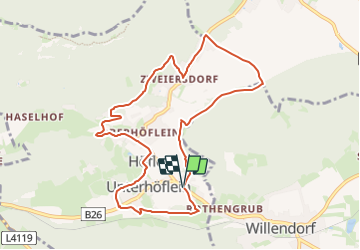
Randonnée A pied de 9,2 km à découvrir à Basse-Autriche, Bezirk Neunkirchen, Gemeinde Höflein an der Hohen Wand. Cette randonnée est proposée par SityTrail - itinéraires balisés pédestres.
Symbole: gezeichnete Hand auf weiß-grüne Tafel
 "
data-pinterest-text="Pin it"
data-tweet-text="share on twitter"
data-facebook-share-url="https://www.sitytrail.com/fr/trails/3128741-gemeinde-hoflein-an-der-hohen-wand--erlebnisweg-xmit-allen-sinnen-geniexenx/?photo=1#lg=1&slide=1"
data-twitter-share-url="https://www.sitytrail.com/fr/trails/3128741-gemeinde-hoflein-an-der-hohen-wand--erlebnisweg-xmit-allen-sinnen-geniexenx/?photo=1#lg=1&slide=1"
data-googleplus-share-url="https://www.sitytrail.com/fr/trails/3128741-gemeinde-hoflein-an-der-hohen-wand--erlebnisweg-xmit-allen-sinnen-geniexenx/?photo=1#lg=1&slide=1"
data-pinterest-share-url="https://www.sitytrail.com/fr/trails/3128741-gemeinde-hoflein-an-der-hohen-wand--erlebnisweg-xmit-allen-sinnen-geniexenx/?photo=1#lg=1&slide=1">
"
data-pinterest-text="Pin it"
data-tweet-text="share on twitter"
data-facebook-share-url="https://www.sitytrail.com/fr/trails/3128741-gemeinde-hoflein-an-der-hohen-wand--erlebnisweg-xmit-allen-sinnen-geniexenx/?photo=1#lg=1&slide=1"
data-twitter-share-url="https://www.sitytrail.com/fr/trails/3128741-gemeinde-hoflein-an-der-hohen-wand--erlebnisweg-xmit-allen-sinnen-geniexenx/?photo=1#lg=1&slide=1"
data-googleplus-share-url="https://www.sitytrail.com/fr/trails/3128741-gemeinde-hoflein-an-der-hohen-wand--erlebnisweg-xmit-allen-sinnen-geniexenx/?photo=1#lg=1&slide=1"
data-pinterest-share-url="https://www.sitytrail.com/fr/trails/3128741-gemeinde-hoflein-an-der-hohen-wand--erlebnisweg-xmit-allen-sinnen-geniexenx/?photo=1#lg=1&slide=1">
 "
data-pinterest-text="Pin it"
data-tweet-text="share on twitter"
data-facebook-share-url="https://www.sitytrail.com/fr/trails/3128741-gemeinde-hoflein-an-der-hohen-wand--erlebnisweg-xmit-allen-sinnen-geniexenx/?photo=2#lg=1&slide=2"
data-twitter-share-url="https://www.sitytrail.com/fr/trails/3128741-gemeinde-hoflein-an-der-hohen-wand--erlebnisweg-xmit-allen-sinnen-geniexenx/?photo=2#lg=1&slide=2"
data-googleplus-share-url="https://www.sitytrail.com/fr/trails/3128741-gemeinde-hoflein-an-der-hohen-wand--erlebnisweg-xmit-allen-sinnen-geniexenx/?photo=2#lg=1&slide=2"
data-pinterest-share-url="https://www.sitytrail.com/fr/trails/3128741-gemeinde-hoflein-an-der-hohen-wand--erlebnisweg-xmit-allen-sinnen-geniexenx/?photo=2#lg=1&slide=2">
"
data-pinterest-text="Pin it"
data-tweet-text="share on twitter"
data-facebook-share-url="https://www.sitytrail.com/fr/trails/3128741-gemeinde-hoflein-an-der-hohen-wand--erlebnisweg-xmit-allen-sinnen-geniexenx/?photo=2#lg=1&slide=2"
data-twitter-share-url="https://www.sitytrail.com/fr/trails/3128741-gemeinde-hoflein-an-der-hohen-wand--erlebnisweg-xmit-allen-sinnen-geniexenx/?photo=2#lg=1&slide=2"
data-googleplus-share-url="https://www.sitytrail.com/fr/trails/3128741-gemeinde-hoflein-an-der-hohen-wand--erlebnisweg-xmit-allen-sinnen-geniexenx/?photo=2#lg=1&slide=2"
data-pinterest-share-url="https://www.sitytrail.com/fr/trails/3128741-gemeinde-hoflein-an-der-hohen-wand--erlebnisweg-xmit-allen-sinnen-geniexenx/?photo=2#lg=1&slide=2">
 "
data-pinterest-text="Pin it"
data-tweet-text="share on twitter"
data-facebook-share-url="https://www.sitytrail.com/fr/trails/3128741-gemeinde-hoflein-an-der-hohen-wand--erlebnisweg-xmit-allen-sinnen-geniexenx/?photo=3#lg=1&slide=3"
data-twitter-share-url="https://www.sitytrail.com/fr/trails/3128741-gemeinde-hoflein-an-der-hohen-wand--erlebnisweg-xmit-allen-sinnen-geniexenx/?photo=3#lg=1&slide=3"
data-googleplus-share-url="https://www.sitytrail.com/fr/trails/3128741-gemeinde-hoflein-an-der-hohen-wand--erlebnisweg-xmit-allen-sinnen-geniexenx/?photo=3#lg=1&slide=3"
data-pinterest-share-url="https://www.sitytrail.com/fr/trails/3128741-gemeinde-hoflein-an-der-hohen-wand--erlebnisweg-xmit-allen-sinnen-geniexenx/?photo=3#lg=1&slide=3">
"
data-pinterest-text="Pin it"
data-tweet-text="share on twitter"
data-facebook-share-url="https://www.sitytrail.com/fr/trails/3128741-gemeinde-hoflein-an-der-hohen-wand--erlebnisweg-xmit-allen-sinnen-geniexenx/?photo=3#lg=1&slide=3"
data-twitter-share-url="https://www.sitytrail.com/fr/trails/3128741-gemeinde-hoflein-an-der-hohen-wand--erlebnisweg-xmit-allen-sinnen-geniexenx/?photo=3#lg=1&slide=3"
data-googleplus-share-url="https://www.sitytrail.com/fr/trails/3128741-gemeinde-hoflein-an-der-hohen-wand--erlebnisweg-xmit-allen-sinnen-geniexenx/?photo=3#lg=1&slide=3"
data-pinterest-share-url="https://www.sitytrail.com/fr/trails/3128741-gemeinde-hoflein-an-der-hohen-wand--erlebnisweg-xmit-allen-sinnen-geniexenx/?photo=3#lg=1&slide=3">
 "
data-pinterest-text="Pin it"
data-tweet-text="share on twitter"
data-facebook-share-url="https://www.sitytrail.com/fr/trails/3128741-gemeinde-hoflein-an-der-hohen-wand--erlebnisweg-xmit-allen-sinnen-geniexenx/?photo=4#lg=1&slide=4"
data-twitter-share-url="https://www.sitytrail.com/fr/trails/3128741-gemeinde-hoflein-an-der-hohen-wand--erlebnisweg-xmit-allen-sinnen-geniexenx/?photo=4#lg=1&slide=4"
data-googleplus-share-url="https://www.sitytrail.com/fr/trails/3128741-gemeinde-hoflein-an-der-hohen-wand--erlebnisweg-xmit-allen-sinnen-geniexenx/?photo=4#lg=1&slide=4"
data-pinterest-share-url="https://www.sitytrail.com/fr/trails/3128741-gemeinde-hoflein-an-der-hohen-wand--erlebnisweg-xmit-allen-sinnen-geniexenx/?photo=4#lg=1&slide=4">
"
data-pinterest-text="Pin it"
data-tweet-text="share on twitter"
data-facebook-share-url="https://www.sitytrail.com/fr/trails/3128741-gemeinde-hoflein-an-der-hohen-wand--erlebnisweg-xmit-allen-sinnen-geniexenx/?photo=4#lg=1&slide=4"
data-twitter-share-url="https://www.sitytrail.com/fr/trails/3128741-gemeinde-hoflein-an-der-hohen-wand--erlebnisweg-xmit-allen-sinnen-geniexenx/?photo=4#lg=1&slide=4"
data-googleplus-share-url="https://www.sitytrail.com/fr/trails/3128741-gemeinde-hoflein-an-der-hohen-wand--erlebnisweg-xmit-allen-sinnen-geniexenx/?photo=4#lg=1&slide=4"
data-pinterest-share-url="https://www.sitytrail.com/fr/trails/3128741-gemeinde-hoflein-an-der-hohen-wand--erlebnisweg-xmit-allen-sinnen-geniexenx/?photo=4#lg=1&slide=4">
 "
data-pinterest-text="Pin it"
data-tweet-text="share on twitter"
data-facebook-share-url="https://www.sitytrail.com/fr/trails/3128741-gemeinde-hoflein-an-der-hohen-wand--erlebnisweg-xmit-allen-sinnen-geniexenx/?photo=5#lg=1&slide=5"
data-twitter-share-url="https://www.sitytrail.com/fr/trails/3128741-gemeinde-hoflein-an-der-hohen-wand--erlebnisweg-xmit-allen-sinnen-geniexenx/?photo=5#lg=1&slide=5"
data-googleplus-share-url="https://www.sitytrail.com/fr/trails/3128741-gemeinde-hoflein-an-der-hohen-wand--erlebnisweg-xmit-allen-sinnen-geniexenx/?photo=5#lg=1&slide=5"
data-pinterest-share-url="https://www.sitytrail.com/fr/trails/3128741-gemeinde-hoflein-an-der-hohen-wand--erlebnisweg-xmit-allen-sinnen-geniexenx/?photo=5#lg=1&slide=5">
"
data-pinterest-text="Pin it"
data-tweet-text="share on twitter"
data-facebook-share-url="https://www.sitytrail.com/fr/trails/3128741-gemeinde-hoflein-an-der-hohen-wand--erlebnisweg-xmit-allen-sinnen-geniexenx/?photo=5#lg=1&slide=5"
data-twitter-share-url="https://www.sitytrail.com/fr/trails/3128741-gemeinde-hoflein-an-der-hohen-wand--erlebnisweg-xmit-allen-sinnen-geniexenx/?photo=5#lg=1&slide=5"
data-googleplus-share-url="https://www.sitytrail.com/fr/trails/3128741-gemeinde-hoflein-an-der-hohen-wand--erlebnisweg-xmit-allen-sinnen-geniexenx/?photo=5#lg=1&slide=5"
data-pinterest-share-url="https://www.sitytrail.com/fr/trails/3128741-gemeinde-hoflein-an-der-hohen-wand--erlebnisweg-xmit-allen-sinnen-geniexenx/?photo=5#lg=1&slide=5">
 "
data-pinterest-text="Pin it"
data-tweet-text="share on twitter"
data-facebook-share-url="https://www.sitytrail.com/fr/trails/3128741-gemeinde-hoflein-an-der-hohen-wand--erlebnisweg-xmit-allen-sinnen-geniexenx/?photo=6#lg=1&slide=6"
data-twitter-share-url="https://www.sitytrail.com/fr/trails/3128741-gemeinde-hoflein-an-der-hohen-wand--erlebnisweg-xmit-allen-sinnen-geniexenx/?photo=6#lg=1&slide=6"
data-googleplus-share-url="https://www.sitytrail.com/fr/trails/3128741-gemeinde-hoflein-an-der-hohen-wand--erlebnisweg-xmit-allen-sinnen-geniexenx/?photo=6#lg=1&slide=6"
data-pinterest-share-url="https://www.sitytrail.com/fr/trails/3128741-gemeinde-hoflein-an-der-hohen-wand--erlebnisweg-xmit-allen-sinnen-geniexenx/?photo=6#lg=1&slide=6">
"
data-pinterest-text="Pin it"
data-tweet-text="share on twitter"
data-facebook-share-url="https://www.sitytrail.com/fr/trails/3128741-gemeinde-hoflein-an-der-hohen-wand--erlebnisweg-xmit-allen-sinnen-geniexenx/?photo=6#lg=1&slide=6"
data-twitter-share-url="https://www.sitytrail.com/fr/trails/3128741-gemeinde-hoflein-an-der-hohen-wand--erlebnisweg-xmit-allen-sinnen-geniexenx/?photo=6#lg=1&slide=6"
data-googleplus-share-url="https://www.sitytrail.com/fr/trails/3128741-gemeinde-hoflein-an-der-hohen-wand--erlebnisweg-xmit-allen-sinnen-geniexenx/?photo=6#lg=1&slide=6"
data-pinterest-share-url="https://www.sitytrail.com/fr/trails/3128741-gemeinde-hoflein-an-der-hohen-wand--erlebnisweg-xmit-allen-sinnen-geniexenx/?photo=6#lg=1&slide=6">
 "
data-pinterest-text="Pin it"
data-tweet-text="share on twitter"
data-facebook-share-url="https://www.sitytrail.com/fr/trails/3128741-gemeinde-hoflein-an-der-hohen-wand--erlebnisweg-xmit-allen-sinnen-geniexenx/?photo=7#lg=1&slide=7"
data-twitter-share-url="https://www.sitytrail.com/fr/trails/3128741-gemeinde-hoflein-an-der-hohen-wand--erlebnisweg-xmit-allen-sinnen-geniexenx/?photo=7#lg=1&slide=7"
data-googleplus-share-url="https://www.sitytrail.com/fr/trails/3128741-gemeinde-hoflein-an-der-hohen-wand--erlebnisweg-xmit-allen-sinnen-geniexenx/?photo=7#lg=1&slide=7"
data-pinterest-share-url="https://www.sitytrail.com/fr/trails/3128741-gemeinde-hoflein-an-der-hohen-wand--erlebnisweg-xmit-allen-sinnen-geniexenx/?photo=7#lg=1&slide=7">
"
data-pinterest-text="Pin it"
data-tweet-text="share on twitter"
data-facebook-share-url="https://www.sitytrail.com/fr/trails/3128741-gemeinde-hoflein-an-der-hohen-wand--erlebnisweg-xmit-allen-sinnen-geniexenx/?photo=7#lg=1&slide=7"
data-twitter-share-url="https://www.sitytrail.com/fr/trails/3128741-gemeinde-hoflein-an-der-hohen-wand--erlebnisweg-xmit-allen-sinnen-geniexenx/?photo=7#lg=1&slide=7"
data-googleplus-share-url="https://www.sitytrail.com/fr/trails/3128741-gemeinde-hoflein-an-der-hohen-wand--erlebnisweg-xmit-allen-sinnen-geniexenx/?photo=7#lg=1&slide=7"
data-pinterest-share-url="https://www.sitytrail.com/fr/trails/3128741-gemeinde-hoflein-an-der-hohen-wand--erlebnisweg-xmit-allen-sinnen-geniexenx/?photo=7#lg=1&slide=7">
 "
data-pinterest-text="Pin it"
data-tweet-text="share on twitter"
data-facebook-share-url="https://www.sitytrail.com/fr/trails/3128741-gemeinde-hoflein-an-der-hohen-wand--erlebnisweg-xmit-allen-sinnen-geniexenx/?photo=8#lg=1&slide=8"
data-twitter-share-url="https://www.sitytrail.com/fr/trails/3128741-gemeinde-hoflein-an-der-hohen-wand--erlebnisweg-xmit-allen-sinnen-geniexenx/?photo=8#lg=1&slide=8"
data-googleplus-share-url="https://www.sitytrail.com/fr/trails/3128741-gemeinde-hoflein-an-der-hohen-wand--erlebnisweg-xmit-allen-sinnen-geniexenx/?photo=8#lg=1&slide=8"
data-pinterest-share-url="https://www.sitytrail.com/fr/trails/3128741-gemeinde-hoflein-an-der-hohen-wand--erlebnisweg-xmit-allen-sinnen-geniexenx/?photo=8#lg=1&slide=8">
"
data-pinterest-text="Pin it"
data-tweet-text="share on twitter"
data-facebook-share-url="https://www.sitytrail.com/fr/trails/3128741-gemeinde-hoflein-an-der-hohen-wand--erlebnisweg-xmit-allen-sinnen-geniexenx/?photo=8#lg=1&slide=8"
data-twitter-share-url="https://www.sitytrail.com/fr/trails/3128741-gemeinde-hoflein-an-der-hohen-wand--erlebnisweg-xmit-allen-sinnen-geniexenx/?photo=8#lg=1&slide=8"
data-googleplus-share-url="https://www.sitytrail.com/fr/trails/3128741-gemeinde-hoflein-an-der-hohen-wand--erlebnisweg-xmit-allen-sinnen-geniexenx/?photo=8#lg=1&slide=8"
data-pinterest-share-url="https://www.sitytrail.com/fr/trails/3128741-gemeinde-hoflein-an-der-hohen-wand--erlebnisweg-xmit-allen-sinnen-geniexenx/?photo=8#lg=1&slide=8">
 "
data-pinterest-text="Pin it"
data-tweet-text="share on twitter"
data-facebook-share-url="https://www.sitytrail.com/fr/trails/3128741-gemeinde-hoflein-an-der-hohen-wand--erlebnisweg-xmit-allen-sinnen-geniexenx/?photo=9#lg=1&slide=9"
data-twitter-share-url="https://www.sitytrail.com/fr/trails/3128741-gemeinde-hoflein-an-der-hohen-wand--erlebnisweg-xmit-allen-sinnen-geniexenx/?photo=9#lg=1&slide=9"
data-googleplus-share-url="https://www.sitytrail.com/fr/trails/3128741-gemeinde-hoflein-an-der-hohen-wand--erlebnisweg-xmit-allen-sinnen-geniexenx/?photo=9#lg=1&slide=9"
data-pinterest-share-url="https://www.sitytrail.com/fr/trails/3128741-gemeinde-hoflein-an-der-hohen-wand--erlebnisweg-xmit-allen-sinnen-geniexenx/?photo=9#lg=1&slide=9">
"
data-pinterest-text="Pin it"
data-tweet-text="share on twitter"
data-facebook-share-url="https://www.sitytrail.com/fr/trails/3128741-gemeinde-hoflein-an-der-hohen-wand--erlebnisweg-xmit-allen-sinnen-geniexenx/?photo=9#lg=1&slide=9"
data-twitter-share-url="https://www.sitytrail.com/fr/trails/3128741-gemeinde-hoflein-an-der-hohen-wand--erlebnisweg-xmit-allen-sinnen-geniexenx/?photo=9#lg=1&slide=9"
data-googleplus-share-url="https://www.sitytrail.com/fr/trails/3128741-gemeinde-hoflein-an-der-hohen-wand--erlebnisweg-xmit-allen-sinnen-geniexenx/?photo=9#lg=1&slide=9"
data-pinterest-share-url="https://www.sitytrail.com/fr/trails/3128741-gemeinde-hoflein-an-der-hohen-wand--erlebnisweg-xmit-allen-sinnen-geniexenx/?photo=9#lg=1&slide=9">


A pied

A pied
A pied

A pied
A pied

A pied

A pied
A pied
A pied