![](/images/other/stat-length.png)
![Randonnée A pied Gemeinde Grafenschlag - Walpurgisweg - Photo](https://media.geolcdn.com/t/1900/400/ext.pjpeg?maxdim=2&url=https%3A%2F%2Fmedia.geolcdn.com%2Ff%2F6848955c-59a9-404c-84a6-06a4b8e33d83.jpeg)
Walpurgisweg
SityTrail - itinéraires balisés pédestres
Tous les sentiers balisés d’Europe PRO
![Longueur](/images/other/stat-length.png)
Longueur
8,2 km
![Altitude max](https://static1.geolcdn.com/siteimages/upload/files/1508320355ic_sort_altitude_max_24dp.png)
Altitude max
818 m
![Dénivelé positif](https://static1.geolcdn.com/siteimages/upload/files/1508320355ic_sort_den_pos_24dp.png)
Dénivelé positif
170 m
![Km-Effort](/images/other/stat-length.png)
Km-Effort
10,4 km
![Altitude min](https://static1.geolcdn.com/siteimages/upload/files/1508320355ic_sort_altitude_min_24dp.png)
Altitude min
744 m
![Dénivelé négatif](https://static1.geolcdn.com/siteimages/upload/files/1508320355ic_sort_den_neg_24dp.png)
Dénivelé négatif
134 m
![Boucle](https://static1.geolcdn.com/siteimages/upload/files/16400158638029165_repeat_loop_refresh_sync_direction_icon.png)
Boucle
Non
Balise
Date de création :
2022-02-16 17:00:29.018
Dernière modification :
2022-03-03 15:15:09.333
![A pied](https://static1.geolcdn.com/sitytour/trail-icons/100.png)
2h21
Difficulté : Facile
![Scannez ce code QR pour ouvrir la randonnée dans l'application SityTrail](https://capi.geolives.com/qq0zvz2zws4bq2lad0pu/sitytour/trails/3128535/qr.png?size=200)
Application GPS de randonnée GRATUITE
À propos
Randonnée A pied de 8,2 km à découvrir à Basse-Autriche, Bezirk Zwettl, Gemeinde Grafenschlag. Cette randonnée est proposée par SityTrail - itinéraires balisés pédestres.
Description
https://www.zwalk.at/walpurgisweg/ ; https://www.bergfex.at/sommer/niederoesterreich/touren/wanderung/40288,zwalk-grafenschlag-walpurgisweg/
Symbole: Gelber Pfeil 80
Localisation
Pays :
Autriche
Région :
Basse-Autriche
Département/Province :
Bezirk Zwettl
Commune :
Gemeinde Grafenschlag
Localité :
Unknown
Départ:(Dec)
Départ:(UTM)
512582 ; 5370408 (33U) N.
Commentaires
Randonnées à proximité
![Randonnée A pied Gemeinde Ottenschlag - Mohnstrudelweg 13 O'zwickte - Photo](https://media.geolcdn.com/t/375/260/ext.jpg?maxdim=2&url=https%3A%2F%2Fmedia.geolcdn.com%2Ff%2Fd22a0399-08ea-4973-b588-8b4bb3c59554.jpeg)
![A pied A pied](https://static1.geolcdn.com/sitytour/trail-icons/100.png)
Mohnstrudelweg 13 O'zwickte
A pied
Facile
Gemeinde Ottenschlag,
Basse-Autriche,
Bezirk Zwettl,
Autriche
![](/images/other/stat-length.png)
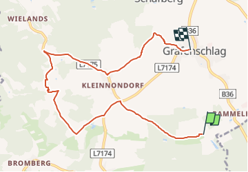
9,2 km | 11,7 km-effort
2h 40min
![](https://static1.geolcdn.com/siteimages/upload/files/16400158638029165_repeat_loop_refresh_sync_direction_icon.png)
Oui
![Randonnée A pied Gemeinde Sallingberg - Mönchwaldweg 14 - ora et labora - Photo](https://media.geolcdn.com/t/375/260/ext.jpg?maxdim=2&url=https%3A%2F%2Fmedia.geolcdn.com%2Ff%2Fe5e6daf9-9c39-4faf-9abb-d49afafbbc89.jpeg)
![A pied A pied](https://static1.geolcdn.com/sitytour/trail-icons/100.png)
Mönchwaldweg 14 - ora et labora
A pied
Facile
Gemeinde Sallingberg,
Basse-Autriche,
Bezirk Zwettl,
Autriche
![](/images/other/stat-length.png)
11,9 km | 14,7 km-effort
3h 20min
![](https://static1.geolcdn.com/siteimages/upload/files/16400158638029165_repeat_loop_refresh_sync_direction_icon.png)
Oui
![Randonnée A pied Gemeinde Sallingberg - Mohnleut'weg 11 - Photo](https://media.geolcdn.com/t/375/260/ext.jpg?maxdim=2&url=https%3A%2F%2Fmedia.geolcdn.com%2Ff%2F24091f08-0923-49f0-906b-c134e5424bf3.jpeg)
![A pied A pied](https://static1.geolcdn.com/sitytour/trail-icons/100.png)
Mohnleut'weg 11
A pied
Facile
Gemeinde Sallingberg,
Basse-Autriche,
Bezirk Zwettl,
Autriche
![](/images/other/stat-length.png)
7,9 km | 9,8 km-effort
2h 12min
![](https://static1.geolcdn.com/siteimages/upload/files/16400158638029165_repeat_loop_refresh_sync_direction_icon.png)
Oui