![](/images/other/stat-length.png)
![Randonnée A pied Thannhausen - Wanderweg 11a - Photo](https://media.geolcdn.com/t/1900/400/52a0ac9a-74ad-4b48-9d3e-f7dff0d0125c.jpeg&format=pjpeg&maxdim=2)
Wanderweg 11a
SityTrail - itinéraires balisés pédestres
Tous les sentiers balisés d’Europe GUIDE+
![Longueur](/images/other/stat-length.png)
Longueur
3 km
![Altitude max](https://static1.geolcdn.com/siteimages/upload/files/1508320355ic_sort_altitude_max_24dp.png)
Altitude max
643 m
![Dénivelé positif](https://static1.geolcdn.com/siteimages/upload/files/1508320355ic_sort_den_pos_24dp.png)
Dénivelé positif
22 m
![Km-Effort](/images/other/stat-length.png)
Km-Effort
3,7 km
![Altitude min](https://static1.geolcdn.com/siteimages/upload/files/1508320355ic_sort_altitude_min_24dp.png)
Altitude min
497 m
![Dénivelé négatif](https://static1.geolcdn.com/siteimages/upload/files/1508320355ic_sort_den_neg_24dp.png)
Dénivelé négatif
140 m
![Boucle](https://static1.geolcdn.com/siteimages/upload/files/16400158638029165_repeat_loop_refresh_sync_direction_icon.png)
Boucle
Non
Balise
Date de création :
2022-02-16 16:52:53.378
Dernière modification :
2022-03-03 13:28:15.823
![A pied](https://static1.geolcdn.com/sitytour/trail-icons/100.png)
50m
Difficulté : Facile
![Scannez ce code QR pour ouvrir la randonnée dans l'application SityTrail](https://capi.geolives.com/qq0zvz2zws4bq2lad0pu/sitytour/trails/3128190/qr.png?size=200)
Application GPS de randonnée GRATUITE
À propos
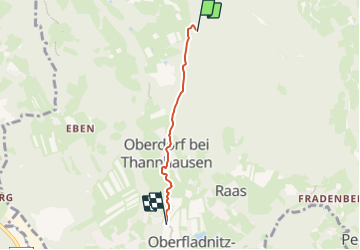
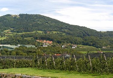
Randonnée A pied de 3 km à découvrir à Styrie, Bezirk Weiz, Thannhausen. Cette randonnée est proposée par SityTrail - itinéraires balisés pédestres.
Description
Randonnée créée par Naturfreunde Weiz.
http://wiki.openstreetmap.org/index.php?title=WikiProject_Austria/Wanderwege
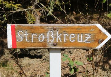
Symbole: Rot-Weiss-Rot 11a
Localisation
Pays :
Autriche
Région :
Styrie
Département/Province :
Bezirk Weiz
Commune :
Thannhausen
Localité :
Unknown
Départ:(Dec)
Départ:(UTM)
548813 ; 5233560 (33T) N.
Commentaires
Randonnées à proximité
![Randonnée A pied Mortantsch - Wanderweg 4 - Photo](https://media.geolcdn.com/t/375/260/fdd16baf-e923-44dc-9e9c-1fa6a9692d35.jpeg&format=jpg&maxdim=2)
![A pied A pied](https://static1.geolcdn.com/sitytour/trail-icons/100.png)
Wanderweg 4
A pied
Facile
Mortantsch,
Styrie,
Bezirk Weiz,
Autriche
![](/images/other/stat-length.png)
10,2 km | 15 km-effort
3h 24min
![](https://static1.geolcdn.com/siteimages/upload/files/16400158638029165_repeat_loop_refresh_sync_direction_icon.png)
Oui
![Randonnée A pied Weiz - Weizer Erlebniswanderweg - Photo](https://media.geolcdn.com/t/375/260/ef29118a-8c2e-4d73-9a2f-1bc926cc976d.jpeg&format=jpg&maxdim=2)
![A pied A pied](https://static1.geolcdn.com/sitytour/trail-icons/100.png)
Weizer Erlebniswanderweg
A pied
Facile
Weiz,
Styrie,
Bezirk Weiz,
Autriche
![](/images/other/stat-length.png)
10,5 km | 13,9 km-effort
3h 9min
![](https://static1.geolcdn.com/siteimages/upload/files/16400158638029165_repeat_loop_refresh_sync_direction_icon.png)
Non
![Randonnée A pied Anger - Wanderweg 1 - Photo](https://media.geolcdn.com/t/375/260/9155dc1a-ba53-4b92-b8e4-dd2f820be1ce.jpeg&format=jpg&maxdim=2)
![A pied A pied](https://static1.geolcdn.com/sitytour/trail-icons/100.png)
![Randonnée A pied Anger - Grubbründlweg - Photo](https://media.geolcdn.com/t/375/260/f7c032e2-41c2-4c1f-b0fc-a6c154a813ae.jpeg&format=jpg&maxdim=2)
![A pied A pied](https://static1.geolcdn.com/sitytour/trail-icons/100.png)
Grubbründlweg
A pied
Facile
Anger,
Styrie,
Bezirk Weiz,
Autriche
![](/images/other/stat-length.png)
14,3 km | 19,7 km-effort
4h 28min
![](https://static1.geolcdn.com/siteimages/upload/files/16400158638029165_repeat_loop_refresh_sync_direction_icon.png)
Non
![Randonnée A pied Puch bei Weiz - Ilzbergrunde - Photo](https://media.geolcdn.com/t/375/260/73b3cd53-0e31-4d0c-b653-942b25b8c8f7.jpeg&format=jpg&maxdim=2)
![A pied A pied](https://static1.geolcdn.com/sitytour/trail-icons/100.png)
Ilzbergrunde
A pied
Facile
Puch bei Weiz,
Styrie,
Bezirk Weiz,
Autriche
![](/images/other/stat-length.png)
10 km | 14,4 km-effort
3h 16min
![](https://static1.geolcdn.com/siteimages/upload/files/16400158638029165_repeat_loop_refresh_sync_direction_icon.png)
Oui
![Randonnée A pied Anger - Erlebniswanderweg - Photo](https://media.geolcdn.com/t/375/260/1f2c3743-4a68-4166-b866-7806c8d3937d.jpeg&format=jpg&maxdim=2)
![A pied A pied](https://static1.geolcdn.com/sitytour/trail-icons/100.png)
Erlebniswanderweg
A pied
Facile
Anger,
Styrie,
Bezirk Weiz,
Autriche
![](/images/other/stat-length.png)
6,3 km | 10,8 km-effort
2h 26min
![](https://static1.geolcdn.com/siteimages/upload/files/16400158638029165_repeat_loop_refresh_sync_direction_icon.png)
Oui
![Randonnée A pied Weiz - Apfelwanderweg - Photo](https://media.geolcdn.com/t/375/260/a3736f39-258b-41cd-b201-43a8776f63c3.jpeg&format=jpg&maxdim=2)
![A pied A pied](https://static1.geolcdn.com/sitytour/trail-icons/100.png)
Apfelwanderweg
A pied
Facile
Weiz,
Styrie,
Bezirk Weiz,
Autriche
![](/images/other/stat-length.png)
8,7 km | 11,5 km-effort
2h 37min
![](https://static1.geolcdn.com/siteimages/upload/files/16400158638029165_repeat_loop_refresh_sync_direction_icon.png)
Non
![Randonnée A pied Weiz - Wanderweg 13 - Photo](https://media.geolcdn.com/t/375/260/432fd02e-e13a-4714-b82d-e7327c8ec93b.jpeg&format=jpg&maxdim=2)
![A pied A pied](https://static1.geolcdn.com/sitytour/trail-icons/100.png)
![Randonnée A pied Weiz - Wanderweg 3 - Photo](https://media.geolcdn.com/t/375/260/840e4b6a-939f-4ec8-85a5-441e97e41556.jpeg&format=jpg&maxdim=2)
![A pied A pied](https://static1.geolcdn.com/sitytour/trail-icons/100.png)