![](/images/other/stat-length.png)
![Randonnée A pied Thal - Arnold Schwarzenegger Wanderweg - Photo](https://media.geolcdn.com/t/1900/400/27b69a35-96e2-4eaa-92ef-745945ffc9e7.jpeg&format=pjpeg&maxdim=2)
Arnold Schwarzenegger Wanderweg
SityTrail - itinéraires balisés pédestres
Tous les sentiers balisés d’Europe GUIDE+
![Longueur](/images/other/stat-length.png)
Longueur
6,1 km
![Altitude max](https://static1.geolcdn.com/siteimages/upload/files/1508320355ic_sort_altitude_max_24dp.png)
Altitude max
544 m
![Dénivelé positif](https://static1.geolcdn.com/siteimages/upload/files/1508320355ic_sort_den_pos_24dp.png)
Dénivelé positif
160 m
![Km-Effort](/images/other/stat-length.png)
Km-Effort
8,3 km
![Altitude min](https://static1.geolcdn.com/siteimages/upload/files/1508320355ic_sort_altitude_min_24dp.png)
Altitude min
434 m
![Dénivelé négatif](https://static1.geolcdn.com/siteimages/upload/files/1508320355ic_sort_den_neg_24dp.png)
Dénivelé négatif
182 m
![Boucle](https://static1.geolcdn.com/siteimages/upload/files/16400158638029165_repeat_loop_refresh_sync_direction_icon.png)
Boucle
Non
Balise
Date de création :
2022-02-16 16:07:23.254
Dernière modification :
2022-03-03 01:31:47.254
![A pied](https://static1.geolcdn.com/sitytour/trail-icons/100.png)
1h53
Difficulté : Facile
![Scannez ce code QR pour ouvrir la randonnée dans l'application SityTrail](https://capi.geolives.com/qq0zvz2zws4bq2lad0pu/sitytour/trails/3126006/qr.png?size=200)
Application GPS de randonnée GRATUITE
À propos
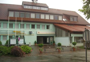
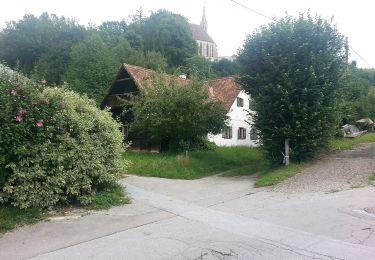
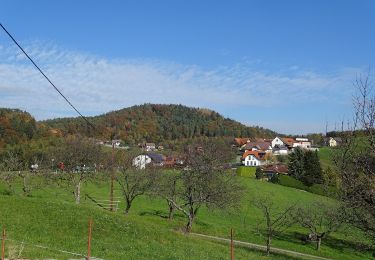
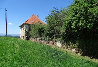
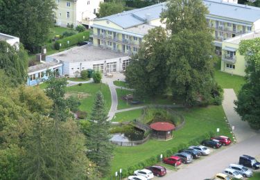
Randonnée A pied de 6,1 km à découvrir à Styrie, Bezirk Graz-Umgebung, Thal. Cette randonnée est proposée par SityTrail - itinéraires balisés pédestres.
Description
Symbole: Kopf mit Wappen
Site web: https://thal.gv.at/arnold-schwarzenegger-wanderweg/
Localisation
Pays :
Autriche
Région :
Styrie
Département/Province :
Bezirk Graz-Umgebung
Commune :
Thal
Localité :
Unknown
Départ:(Dec)
Départ:(UTM)
526586 ; 5213332 (33T) N.
Commentaires
Randonnées à proximité
![Randonnée A pied Hitzendorf - Auf den Spuren von Österr-Weiß - Photo](https://media.geolcdn.com/t/375/260/a0e35225-25c1-4707-9eac-cdb4afc8dded.jpeg&format=jpg&maxdim=2)
![A pied A pied](https://static1.geolcdn.com/sitytour/trail-icons/100.png)
Auf den Spuren von Österr-Weiß
A pied
Facile
Hitzendorf,
Styrie,
Bezirk Graz-Umgebung,
Autriche
![](/images/other/stat-length.png)
7,2 km | 10,2 km-effort
2h 19min
![](https://static1.geolcdn.com/siteimages/upload/files/16400158638029165_repeat_loop_refresh_sync_direction_icon.png)
Non
![Randonnée A pied Gratwein-Straßengel - Wanderweg 14 - Photo](https://media.geolcdn.com/t/375/260/145e2a83-b263-4a09-9666-7dd5a74a4f9e.jpeg&format=jpg&maxdim=2)
![A pied A pied](https://static1.geolcdn.com/sitytour/trail-icons/100.png)
Wanderweg 14
A pied
Facile
Gratwein-Straßengel,
Styrie,
Bezirk Graz-Umgebung,
Autriche
![](/images/other/stat-length.png)
3,5 km | 5,9 km-effort
1h 20min
![](https://static1.geolcdn.com/siteimages/upload/files/16400158638029165_repeat_loop_refresh_sync_direction_icon.png)
Non
![Randonnée A pied Sankt Oswald bei Plankenwarth - Wanderweg 34 - Photo](https://media.geolcdn.com/t/375/260/fee6b74c-350d-407e-bbc6-7871ef2279fc.jpeg&format=jpg&maxdim=2)
![A pied A pied](https://static1.geolcdn.com/sitytour/trail-icons/100.png)
Wanderweg 34
A pied
Facile
Sankt Oswald bei Plankenwarth,
Styrie,
Bezirk Graz-Umgebung,
Autriche
![](/images/other/stat-length.png)
4 km | 5,6 km-effort
1h 16min
![](https://static1.geolcdn.com/siteimages/upload/files/16400158638029165_repeat_loop_refresh_sync_direction_icon.png)
Non
![Randonnée A pied Inconnu - Wanderweg 6 - Photo](https://media.geolcdn.com/t/375/260/aa82f8e8-3846-4909-bc5a-24fadefa549b.jpeg&format=jpg&maxdim=2)
![A pied A pied](https://static1.geolcdn.com/sitytour/trail-icons/100.png)
![Randonnée A pied Hitzendorf - Schlösserweg - Photo](https://media.geolcdn.com/t/375/260/8746c95b-f7d3-493b-9de5-737a70948a64.jpeg&format=jpg&maxdim=2)
![A pied A pied](https://static1.geolcdn.com/sitytour/trail-icons/100.png)
Schlösserweg
A pied
Facile
Hitzendorf,
Styrie,
Bezirk Graz-Umgebung,
Autriche
![](/images/other/stat-length.png)
6,6 km | 9,6 km-effort
2h 11min
![](https://static1.geolcdn.com/siteimages/upload/files/16400158638029165_repeat_loop_refresh_sync_direction_icon.png)
Oui
![Randonnée A pied Inconnu - Wanderweg 5 - Photo](https://media.geolcdn.com/t/375/260/aa82f8e8-3846-4909-bc5a-24fadefa549b.jpeg&format=jpg&maxdim=2)
![A pied A pied](https://static1.geolcdn.com/sitytour/trail-icons/100.png)
![Randonnée A pied Inconnu - Wanderweg 31 - Photo](https://media.geolcdn.com/t/375/260/6f0ca973-7c54-478e-aafe-21a3502c3ec8.jpeg&format=jpg&maxdim=2)
![A pied A pied](https://static1.geolcdn.com/sitytour/trail-icons/100.png)
![Randonnée A pied Gratwein-Straßengel - Wanderweg 30 - Photo](https://media.geolcdn.com/t/375/260/8bed89ec-bb6e-4869-8616-4436e3a08253.jpeg&format=jpg&maxdim=2)
![A pied A pied](https://static1.geolcdn.com/sitytour/trail-icons/100.png)
Wanderweg 30
A pied
Facile
Gratwein-Straßengel,
Styrie,
Bezirk Graz-Umgebung,
Autriche
![](/images/other/stat-length.png)
6,9 km | 11,9 km-effort
2h 42min
![](https://static1.geolcdn.com/siteimages/upload/files/16400158638029165_repeat_loop_refresh_sync_direction_icon.png)
Non
![Randonnée A pied Gratwein-Straßengel - Wanderweg 1 - Photo](https://media.geolcdn.com/t/375/260/3c33e0c9-492c-487c-a170-2a6ea3f5dba0.jpeg&format=jpg&maxdim=2)
![A pied A pied](https://static1.geolcdn.com/sitytour/trail-icons/100.png)
Wanderweg 1
A pied
Facile
Gratwein-Straßengel,
Styrie,
Bezirk Graz-Umgebung,
Autriche
![](/images/other/stat-length.png)
12 km | 18 km-effort
4h 5min
![](https://static1.geolcdn.com/siteimages/upload/files/16400158638029165_repeat_loop_refresh_sync_direction_icon.png)
Oui