![](/images/other/stat-length.png)
![Randonnée A pied Villebon-sur-Yvette - Grand Tour de Villebon - Photo](https://media.geolcdn.com/t/1900/400/078fbd2f-b950-4bef-90d6-cedf1ad93ea0.jpeg&format=pjpeg&maxdim=2)
Grand Tour de Villebon
SityTrail - itinéraires balisés pédestres
Tous les sentiers balisés d’Europe GUIDE+
![Longueur](/images/other/stat-length.png)
Longueur
13,1 km
![Altitude max](https://static1.geolcdn.com/siteimages/upload/files/1508320355ic_sort_altitude_max_24dp.png)
Altitude max
167 m
![Dénivelé positif](https://static1.geolcdn.com/siteimages/upload/files/1508320355ic_sort_den_pos_24dp.png)
Dénivelé positif
189 m
![Km-Effort](/images/other/stat-length.png)
Km-Effort
15,6 km
![Altitude min](https://static1.geolcdn.com/siteimages/upload/files/1508320355ic_sort_altitude_min_24dp.png)
Altitude min
43 m
![Dénivelé négatif](https://static1.geolcdn.com/siteimages/upload/files/1508320355ic_sort_den_neg_24dp.png)
Dénivelé négatif
191 m
![Boucle](https://static1.geolcdn.com/siteimages/upload/files/16400158638029165_repeat_loop_refresh_sync_direction_icon.png)
Boucle
Oui
Balise
Date de création :
2022-02-15 19:26:54.644
Dernière modification :
2022-03-03 00:04:05.047
![A pied](https://static1.geolcdn.com/sitytour/trail-icons/100.png)
3h32
Difficulté : Facile
![Scannez ce code QR pour ouvrir la randonnée dans l'application SityTrail](https://capi.geolives.com/qq0zvz2zws4bq2lad0pu/sitytour/trails/3124731/qr.png?size=200)
Application GPS de randonnée GRATUITE
À propos
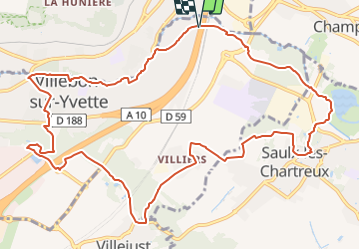
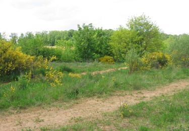
Randonnée A pied de 13,1 km à découvrir à Île-de-France, Essonne, Villebon-sur-Yvette. Cette randonnée est proposée par SityTrail - itinéraires balisés pédestres.
Description
Symbole: yellow bar
Localisation
Pays :
France
Région :
Île-de-France
Département/Province :
Essonne
Commune :
Villebon-sur-Yvette
Localité :
Unknown
Départ:(Dec)
Départ:(UTM)
444833 ; 5395188 (31U) N.
Commentaires
Randonnées à proximité
![Randonnée Marche Ballainvilliers - GRP CV-IDF 17R Ballainvilliers à Vauhallan - Photo](https://media.geolcdn.com/t/375/260/0b5967b2-2c8e-4675-a0f7-553186b66225.jpg&format=jpg&maxdim=2)
![Marche Marche](https://static1.geolcdn.com/sitytour/trail-icons/101.png)
GRP CV-IDF 17R Ballainvilliers à Vauhallan
Marche
Très difficile
(1)
Ballainvilliers,
Île-de-France,
Essonne,
France
![](/images/other/stat-length.png)
15,5 km | 19,1 km-effort
4h 20min
![](https://static1.geolcdn.com/siteimages/upload/files/16400158638029165_repeat_loop_refresh_sync_direction_icon.png)
Non
![Randonnée Marche Bièvres - De Bièvres à Antony - Photo](https://media.geolcdn.com/t/375/260/ext.jpg?maxdim=2&url=https%3A%2F%2Fservices.sitytrail.com%2FGeolivesWS%2FDownloadMedia.ashx%3FTrailID%3D106789%26Media%3D11480_3.jpg)
![Marche Marche](https://static1.geolcdn.com/sitytour/trail-icons/101.png)
De Bièvres à Antony
Marche
Moyen
(1)
Bièvres,
Île-de-France,
Essonne,
France
![](/images/other/stat-length.png)
11,9 km | 14 km-effort
3h 0min
![](https://static1.geolcdn.com/siteimages/upload/files/16400158638029165_repeat_loop_refresh_sync_direction_icon.png)
Non
![Randonnée Marche Palaiseau - De Lozere à Gif sur Yvette - Photo](https://media.geolcdn.com/t/375/260/ext.jpg?maxdim=2&url=https%3A%2F%2Fservices.sitytrail.com%2FGeolivesWS%2FDownloadMedia.ashx%3FTrailID%3D106655%26Media%3D11272_3.jpg)
![Marche Marche](https://static1.geolcdn.com/sitytour/trail-icons/101.png)
De Lozere à Gif sur Yvette
Marche
Moyen
(1)
Palaiseau,
Île-de-France,
Essonne,
France
![](/images/other/stat-length.png)
21 km | 28 km-effort
5h 0min
![](https://static1.geolcdn.com/siteimages/upload/files/16400158638029165_repeat_loop_refresh_sync_direction_icon.png)
Oui
![Randonnée Marche Saulx-les-Chartreux - Saulx les Chartreux vers Ville du Bois - Photo](https://media.geolcdn.com/t/375/260/ext.jpg?maxdim=2&url=https%3A%2F%2Fservices.sitytrail.com%2FGeolivesWS%2FDownloadMedia.ashx%3FTrailID%3D103772%26Media%3D6532_3.jpg)
![Marche Marche](https://static1.geolcdn.com/sitytour/trail-icons/101.png)
Saulx les Chartreux vers Ville du Bois
Marche
Moyen
(1)
Saulx-les-Chartreux,
Île-de-France,
Essonne,
France
![](/images/other/stat-length.png)
9,6 km | 12,2 km-effort
2h 30min
![](https://static1.geolcdn.com/siteimages/upload/files/16400158638029165_repeat_loop_refresh_sync_direction_icon.png)
Oui
![Randonnée Marche Bièvres - Autour de Bièvres - Photo](https://media.geolcdn.com/t/375/260/ext.jpg?maxdim=2&url=https%3A%2F%2Fservices.sitytrail.com%2FGeolivesWS%2FDownloadMedia.ashx%3FTrailID%3D102999%26Media%3D4541_2.jpg)
![Marche Marche](https://static1.geolcdn.com/sitytour/trail-icons/101.png)
Autour de Bièvres
Marche
Moyen
(4)
Bièvres,
Île-de-France,
Essonne,
France
![](/images/other/stat-length.png)
7,6 km | 9,4 km-effort
2h 30min
![](https://static1.geolcdn.com/siteimages/upload/files/16400158638029165_repeat_loop_refresh_sync_direction_icon.png)
Oui
![Randonnée Marche Igny - tour du plateau de Saclay V2 - Photo](https://media.geolcdn.com/t/375/260/ext.jpg?maxdim=2&url=https%3A%2F%2Fstatic1.geolcdn.com%2Fsiteimages%2Fupload%2Ffiles%2F1553511878bg_sport_marche.png)
![Marche Marche](https://static1.geolcdn.com/sitytour/trail-icons/101.png)
tour du plateau de Saclay V2
Marche
Très difficile
(1)
Igny,
Île-de-France,
Essonne,
France
![](/images/other/stat-length.png)
21 km | 25 km-effort
5h 36min
![](https://static1.geolcdn.com/siteimages/upload/files/16400158638029165_repeat_loop_refresh_sync_direction_icon.png)
Oui
![Randonnée Marche Longjumeau - Boucle 23 km autour de Longjumeau - Photo](https://media.geolcdn.com/t/375/260/a98102b6-d183-4b5b-8bb0-fb39230ce35c.jpg&format=jpg&maxdim=2)
![Marche Marche](https://static1.geolcdn.com/sitytour/trail-icons/101.png)
Boucle 23 km autour de Longjumeau
Marche
Moyen
Longjumeau,
Île-de-France,
Essonne,
France
![](/images/other/stat-length.png)
23 km | 27 km-effort
4h 48min
![](https://static1.geolcdn.com/siteimages/upload/files/16400158638029165_repeat_loop_refresh_sync_direction_icon.png)
Oui
![Randonnée Marche Verrières-le-Buisson - Boucle autour de Verrières le Buisson - Photo](https://media.geolcdn.com/t/375/260/e3400994-d836-42da-a137-76fd998d9849.jpg&format=jpg&maxdim=2)
![Marche Marche](https://static1.geolcdn.com/sitytour/trail-icons/101.png)
Boucle autour de Verrières le Buisson
Marche
Moyen
Verrières-le-Buisson,
Île-de-France,
Essonne,
France
![](/images/other/stat-length.png)
25 km | 31 km-effort
5h 22min
![](https://static1.geolcdn.com/siteimages/upload/files/16400158638029165_repeat_loop_refresh_sync_direction_icon.png)
Oui
![Randonnée A pied Palaiseau - PR 11 - Photo](https://media.geolcdn.com/t/375/260/1554c568-abca-4e73-a183-09d30e34ef31.jpeg&format=jpg&maxdim=2)
![A pied A pied](https://static1.geolcdn.com/sitytour/trail-icons/100.png)