![](/images/other/stat-length.png)
![Randonnée A pied Riaillé - L'Orée des Bois - Photo](https://media.geolcdn.com/t/1900/400/0f212ac8-10a0-49eb-9eb8-b782e185202d.jpeg&format=pjpeg&maxdim=2)
L'Orée des Bois
SityTrail - itinéraires balisés pédestres
Tous les sentiers balisés d’Europe GUIDE+
![Longueur](/images/other/stat-length.png)
Longueur
9,1 km
![Altitude max](https://static1.geolcdn.com/siteimages/upload/files/1508320355ic_sort_altitude_max_24dp.png)
Altitude max
63 m
![Dénivelé positif](https://static1.geolcdn.com/siteimages/upload/files/1508320355ic_sort_den_pos_24dp.png)
Dénivelé positif
63 m
![Km-Effort](/images/other/stat-length.png)
Km-Effort
9,9 km
![Altitude min](https://static1.geolcdn.com/siteimages/upload/files/1508320355ic_sort_altitude_min_24dp.png)
Altitude min
29 m
![Dénivelé négatif](https://static1.geolcdn.com/siteimages/upload/files/1508320355ic_sort_den_neg_24dp.png)
Dénivelé négatif
61 m
![Boucle](https://static1.geolcdn.com/siteimages/upload/files/16400158638029165_repeat_loop_refresh_sync_direction_icon.png)
Boucle
Oui
Balise
Date de création :
2022-02-15 19:26:13.636
Dernière modification :
2022-03-02 23:57:41.257
![A pied](https://static1.geolcdn.com/sitytour/trail-icons/100.png)
2h15
Difficulté : Facile
![Scannez ce code QR pour ouvrir la randonnée dans l'application SityTrail](https://capi.geolives.com/qq0zvz2zws4bq2lad0pu/sitytour/trails/3124714/qr.png?size=200)
Application GPS de randonnée GRATUITE
À propos
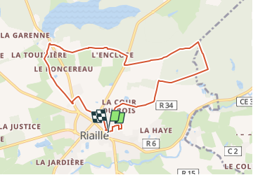
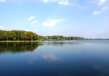
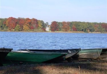
Randonnée A pied de 9,1 km à découvrir à Pays de la Loire, Loire-Atlantique, Riaillé. Cette randonnée est proposée par SityTrail - itinéraires balisés pédestres.
Description
Randonnée créée par Communauté de communes du Pays d'Ancenis.
Symbole: yellow:white:yellow_bar
Localisation
Pays :
France
Région :
Pays de la Loire
Département/Province :
Loire-Atlantique
Commune :
Riaillé
Localité :
Unknown
Départ:(Dec)
Départ:(UTM)
628566 ; 5264106 (30T) N.
Commentaires
Randonnées à proximité
![Randonnée A pied Riaillé - L'étang de la Provostière - Photo](https://media.geolcdn.com/t/375/260/e03313e7-7295-43d3-b9af-cfb7c3ec80f9.jpeg&format=jpg&maxdim=2)
![A pied A pied](https://static1.geolcdn.com/sitytour/trail-icons/100.png)
L'étang de la Provostière
A pied
Facile
Riaillé,
Pays de la Loire,
Loire-Atlantique,
France
![](/images/other/stat-length.png)
5,4 km | 5,8 km-effort
1h 19min
![](https://static1.geolcdn.com/siteimages/upload/files/16400158638029165_repeat_loop_refresh_sync_direction_icon.png)
Oui
![Randonnée A pied Pannecé - Circuit du Donneau - Photo](https://media.geolcdn.com/t/375/260/d20f03d0-a583-462d-a3ae-35fdf6f2e7c5.jpeg&format=jpg&maxdim=2)
![A pied A pied](https://static1.geolcdn.com/sitytour/trail-icons/100.png)
Circuit du Donneau
A pied
Facile
Pannecé,
Pays de la Loire,
Loire-Atlantique,
France
![](/images/other/stat-length.png)
11,2 km | 12 km-effort
2h 43min
![](https://static1.geolcdn.com/siteimages/upload/files/16400158638029165_repeat_loop_refresh_sync_direction_icon.png)
Oui
![Randonnée A pied Riaillé - La vallée de l'Erdre - Photo](https://media.geolcdn.com/t/375/260/0f212ac8-10a0-49eb-9eb8-b782e185202d.jpeg&format=jpg&maxdim=2)
![A pied A pied](https://static1.geolcdn.com/sitytour/trail-icons/100.png)
La vallée de l'Erdre
A pied
Facile
Riaillé,
Pays de la Loire,
Loire-Atlantique,
France
![](/images/other/stat-length.png)
6,5 km | 8,1 km-effort
1h 50min
![](https://static1.geolcdn.com/siteimages/upload/files/16400158638029165_repeat_loop_refresh_sync_direction_icon.png)
Non
![Randonnée Marche Vallons-de-l'Erdre - Petit tour en forêt de Bonnoeuvre sans montée au calvaire - Photo](https://media.geolcdn.com/t/375/260/ext.jpg?maxdim=2&url=https%3A%2F%2Fstatic1.geolcdn.com%2Fsiteimages%2Fupload%2Ffiles%2F1553511878bg_sport_marche.png)
![Marche Marche](https://static1.geolcdn.com/sitytour/trail-icons/101.png)
Petit tour en forêt de Bonnoeuvre sans montée au calvaire
Marche
Moyen
Vallons-de-l'Erdre,
Pays de la Loire,
Loire-Atlantique,
France
![](/images/other/stat-length.png)
6,6 km | 7,6 km-effort
2h 10min
![](https://static1.geolcdn.com/siteimages/upload/files/16400158638029165_repeat_loop_refresh_sync_direction_icon.png)
Oui
![Randonnée Marche Vallons-de-l'Erdre - Petit tour dans la forêt de Bonnoeuvre + montée au calvaire - Photo](https://media.geolcdn.com/t/375/260/ext.jpg?maxdim=2&url=https%3A%2F%2Fstatic1.geolcdn.com%2Fsiteimages%2Fupload%2Ffiles%2F1553511878bg_sport_marche.png)
![Marche Marche](https://static1.geolcdn.com/sitytour/trail-icons/101.png)
Petit tour dans la forêt de Bonnoeuvre + montée au calvaire
Marche
Moyen
Vallons-de-l'Erdre,
Pays de la Loire,
Loire-Atlantique,
France
![](/images/other/stat-length.png)
8,1 km | 9,6 km-effort
2h 10min
![](https://static1.geolcdn.com/siteimages/upload/files/16400158638029165_repeat_loop_refresh_sync_direction_icon.png)
Oui
![Randonnée A pied Vallons-de-l'Erdre - Circuit de la Rotte aux Loups - Photo](https://media.geolcdn.com/t/375/260/ext.jpg?maxdim=2&url=https%3A%2F%2Fstatic1.geolcdn.com%2Fsiteimages%2Fupload%2Ffiles%2F1545311037marcheuse_200dpi.jpg)
![A pied A pied](https://static1.geolcdn.com/sitytour/trail-icons/100.png)
Circuit de la Rotte aux Loups
A pied
Facile
Vallons-de-l'Erdre,
Pays de la Loire,
Loire-Atlantique,
France
![](/images/other/stat-length.png)
6,8 km | 8,4 km-effort
1h 54min
![](https://static1.geolcdn.com/siteimages/upload/files/16400158638029165_repeat_loop_refresh_sync_direction_icon.png)
Oui
![Randonnée V.T.T. Riaillé - Espace VTT FFC Base départementale secteur Vioreau - Riaillé - N°6 - Vallée de l'Erdre - Photo](https://media.geolcdn.com/t/375/260/ext.jpg?maxdim=2&url=https%3A%2F%2Fservices.sitytrail.com%2FGeolivesWS%2FDownloadMedia.ashx%3FTrailID%3D104094%26Media%3D7120_1.jpg)
![V.T.T. V.T.T.](https://static1.geolcdn.com/sitytour/trail-icons/202.png)
Espace VTT FFC Base départementale secteur Vioreau - Riaillé - N°6 - Vallée d...
V.T.T.
Difficile
Riaillé,
Pays de la Loire,
Loire-Atlantique,
France
![](/images/other/stat-length.png)
34 km | 39 km-effort
3h 0min
![](https://static1.geolcdn.com/siteimages/upload/files/16400158638029165_repeat_loop_refresh_sync_direction_icon.png)
Oui
![Randonnée V.T.T. Riaillé - Espace VTT FFC Base départementale secteur Vioreau - Riaillé - N°5 - Rigole d'Alimentation - Photo](https://media.geolcdn.com/t/375/260/ext.jpg?maxdim=2&url=https%3A%2F%2Fservices.sitytrail.com%2FGeolivesWS%2FDownloadMedia.ashx%3FTrailID%3D104093%26Media%3D7119_1.jpg)
![V.T.T. V.T.T.](https://static1.geolcdn.com/sitytour/trail-icons/202.png)
Espace VTT FFC Base départementale secteur Vioreau - Riaillé - N°5 - Rigole d...
V.T.T.
Moyen
Riaillé,
Pays de la Loire,
Loire-Atlantique,
France
![](/images/other/stat-length.png)
24 km | 27 km-effort
2h 0min
![](https://static1.geolcdn.com/siteimages/upload/files/16400158638029165_repeat_loop_refresh_sync_direction_icon.png)
Oui
![Randonnée V.T.T. Riaillé - Espace VTT FFC Base départementale secteur Vioreau - Riaillé - N°4 - Les Etangs - Photo](https://media.geolcdn.com/t/375/260/ext.jpg?maxdim=2&url=https%3A%2F%2Fservices.sitytrail.com%2FGeolivesWS%2FDownloadMedia.ashx%3FTrailID%3D104092%26Media%3D7118_1.jpg)
![V.T.T. V.T.T.](https://static1.geolcdn.com/sitytour/trail-icons/202.png)
Espace VTT FFC Base départementale secteur Vioreau - Riaillé - N°4 - Les Etangs
V.T.T.
Facile
Riaillé,
Pays de la Loire,
Loire-Atlantique,
France
![](/images/other/stat-length.png)
15,7 km | 17,6 km-effort
1h 0min
![](https://static1.geolcdn.com/siteimages/upload/files/16400158638029165_repeat_loop_refresh_sync_direction_icon.png)
Oui