![](/images/other/stat-length.png)
![Randonnée A pied Mont-Dore - Le Capucin et le Puy de Cliergue - Photo](https://media.geolcdn.com/t/1900/400/0a0433ed-5dc0-4bcd-94e6-37a94f9acbcf.jpeg&format=pjpeg&maxdim=2)
Le Capucin et le Puy de Cliergue
SityTrail - itinéraires balisés pédestres
Tous les sentiers balisés d’Europe GUIDE+
![Longueur](/images/other/stat-length.png)
Longueur
10,8 km
![Altitude max](https://static1.geolcdn.com/siteimages/upload/files/1508320355ic_sort_altitude_max_24dp.png)
Altitude max
1727 m
![Dénivelé positif](https://static1.geolcdn.com/siteimages/upload/files/1508320355ic_sort_den_pos_24dp.png)
Dénivelé positif
570 m
![Km-Effort](/images/other/stat-length.png)
Km-Effort
18,4 km
![Altitude min](https://static1.geolcdn.com/siteimages/upload/files/1508320355ic_sort_altitude_min_24dp.png)
Altitude min
1216 m
![Dénivelé négatif](https://static1.geolcdn.com/siteimages/upload/files/1508320355ic_sort_den_neg_24dp.png)
Dénivelé négatif
579 m
![Boucle](https://static1.geolcdn.com/siteimages/upload/files/16400158638029165_repeat_loop_refresh_sync_direction_icon.png)
Boucle
Oui
Balise
Date de création :
2022-02-15 18:57:12.936
Dernière modification :
2022-03-02 22:17:47.785
![A pied](https://static1.geolcdn.com/sitytour/trail-icons/100.png)
4h10
Difficulté : Facile
![Scannez ce code QR pour ouvrir la randonnée dans l'application SityTrail](https://capi.geolives.com/qq0zvz2zws4bq2lad0pu/sitytour/trails/3124103/qr.png?size=200)
Application GPS de randonnée GRATUITE
À propos
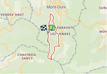
Randonnée A pied de 10,8 km à découvrir à Auvergne-Rhône-Alpes, Puy-de-Dôme, Mont-Dore. Cette randonnée est proposée par SityTrail - itinéraires balisés pédestres.
Description
Randonnée créée par CD63.
Localisation
Pays :
France
Région :
Auvergne-Rhône-Alpes
Département/Province :
Puy-de-Dôme
Commune :
Mont-Dore
Localité :
Unknown
Départ:(Dec)
Départ:(UTM)
484359 ; 5044344 (31T) N.
Commentaires
Randonnées à proximité
![Randonnée Marche La Tour-d'Auvergne - Tour_Auvergne_Chambourguet - Photo](https://media.geolcdn.com/t/375/260/89f1026c-dcfd-4eec-ac48-a164d692d4ad.jpg&format=jpg&maxdim=2)
![Marche Marche](https://static1.geolcdn.com/sitytour/trail-icons/101.png)
Tour_Auvergne_Chambourguet
Marche
Difficile
(1)
La Tour-d'Auvergne,
Auvergne-Rhône-Alpes,
Puy-de-Dôme,
France
![](/images/other/stat-length.png)
17,7 km | 24 km-effort
5h 0min
![](https://static1.geolcdn.com/siteimages/upload/files/16400158638029165_repeat_loop_refresh_sync_direction_icon.png)
Oui
![Randonnée Marche Mont-Dore - Montée au sommet du Puy de Sancy - Photo](https://media.geolcdn.com/t/375/260/1486ae36-afa6-41d3-a8cf-03841ddf3ad3.jpg&format=jpg&maxdim=2)
![Marche Marche](https://static1.geolcdn.com/sitytour/trail-icons/101.png)
Montée au sommet du Puy de Sancy
Marche
Facile
(1)
Mont-Dore,
Auvergne-Rhône-Alpes,
Puy-de-Dôme,
France
![](/images/other/stat-length.png)
1,4 km | 2,7 km-effort
40min
![](https://static1.geolcdn.com/siteimages/upload/files/16400158638029165_repeat_loop_refresh_sync_direction_icon.png)
Oui
![Marche Marche](https://static1.geolcdn.com/sitytour/trail-icons/101.png)
Mont_Dore_Puy_Sancy
Marche
Difficile
(1)
Mont-Dore,
Auvergne-Rhône-Alpes,
Puy-de-Dôme,
France
![](/images/other/stat-length.png)
6,8 km | 13,9 km-effort
2h 0min
![](https://static1.geolcdn.com/siteimages/upload/files/16400158638029165_repeat_loop_refresh_sync_direction_icon.png)
Oui
![Randonnée Marche La Bourboule - Bourboule_Vendeix_Charlannes - Photo](https://media.geolcdn.com/t/375/260/974b84fb-245b-4e5c-88f2-976a8059b2eb.jpg&format=jpg&maxdim=2)
![Marche Marche](https://static1.geolcdn.com/sitytour/trail-icons/101.png)
Bourboule_Vendeix_Charlannes
Marche
Difficile
(1)
La Bourboule,
Auvergne-Rhône-Alpes,
Puy-de-Dôme,
France
![](/images/other/stat-length.png)
15,4 km | 25 km-effort
4h 30min
![](https://static1.geolcdn.com/siteimages/upload/files/16400158638029165_repeat_loop_refresh_sync_direction_icon.png)
Oui
![Marche Marche](https://static1.geolcdn.com/sitytour/trail-icons/101.png)
Chambon_Vallee_Chaudefour_2
Marche
Difficile
(1)
Chambon-sur-Lac,
Auvergne-Rhône-Alpes,
Puy-de-Dôme,
France
![](/images/other/stat-length.png)
15 km | 26 km-effort
4h 30min
![](https://static1.geolcdn.com/siteimages/upload/files/16400158638029165_repeat_loop_refresh_sync_direction_icon.png)
Oui
![Randonnée Marche Mont-Dore - Le puy de la tache, le lacs servières et guèry par la cascade du Queureuilh depuis l'Escalidou. - Photo](https://media.geolcdn.com/t/375/260/ext.jpg?maxdim=2&url=https%3A%2F%2Fservices.sitytrail.com%2FGeolivesWS%2FDownloadMedia.ashx%3FTrailID%3D228422%26Media%3D20131022164253.jpg)
![Marche Marche](https://static1.geolcdn.com/sitytour/trail-icons/101.png)
Le puy de la tache, le lacs servières et guèry par la cascade du Queureuilh d...
Marche
Difficile
(3)
Mont-Dore,
Auvergne-Rhône-Alpes,
Puy-de-Dôme,
France
![](/images/other/stat-length.png)
34 km | 50 km-effort
10h 16min
![](https://static1.geolcdn.com/siteimages/upload/files/16400158638029165_repeat_loop_refresh_sync_direction_icon.png)
Oui
![Randonnée Marche Mont-Dore - le sancy du mont dore par le côté ouest puis revenir par le côté est. - Photo](https://media.geolcdn.com/t/375/260/ext.jpg?maxdim=2&url=https%3A%2F%2Fservices.sitytrail.com%2FGeolivesWS%2FDownloadMedia.ashx%3FTrailID%3D228300%26Media%3D20131021153021.jpg)
![Marche Marche](https://static1.geolcdn.com/sitytour/trail-icons/101.png)
le sancy du mont dore par le côté ouest puis revenir par le côté est.
Marche
Difficile
(2)
Mont-Dore,
Auvergne-Rhône-Alpes,
Puy-de-Dôme,
France
![](/images/other/stat-length.png)
8,2 km | 15,4 km-effort
3h 5min
![](https://static1.geolcdn.com/siteimages/upload/files/16400158638029165_repeat_loop_refresh_sync_direction_icon.png)
Oui
![Randonnée Marche Mont-Dore - Sentier des crêtes Puy de Sancy - Photo](https://media.geolcdn.com/t/375/260/ext.jpg?maxdim=2&url=https%3A%2F%2Fservices.sitytrail.com%2FGeolivesWS%2FDownloadMedia.ashx%3FTrailID%3D106861%26Media%3D11600_5.jpg)
![Marche Marche](https://static1.geolcdn.com/sitytour/trail-icons/101.png)
Sentier des crêtes Puy de Sancy
Marche
Difficile
(2)
Mont-Dore,
Auvergne-Rhône-Alpes,
Puy-de-Dôme,
France
![](/images/other/stat-length.png)
26 km | 46 km-effort
9h 0min
![](https://static1.geolcdn.com/siteimages/upload/files/16400158638029165_repeat_loop_refresh_sync_direction_icon.png)
Oui
![Randonnée Marche Chambon-sur-Lac - puy de sancy - Photo](https://media.geolcdn.com/t/375/260/85d006d0-43eb-47e5-b17f-9793dbe8343f.jpg&format=jpg&maxdim=2)
![Marche Marche](https://static1.geolcdn.com/sitytour/trail-icons/101.png)
puy de sancy
Marche
Difficile
Chambon-sur-Lac,
Auvergne-Rhône-Alpes,
Puy-de-Dôme,
France
![](/images/other/stat-length.png)
9,4 km | 16,4 km-effort
6h 23min
![](https://static1.geolcdn.com/siteimages/upload/files/16400158638029165_repeat_loop_refresh_sync_direction_icon.png)
Non