![](/images/other/stat-length.png)
![Randonnée A pied Touët-sur-Var - Traversée Touët-sur-Var – Villars-sur-Var - Photo](https://media.geolcdn.com/t/1900/400/e3880c6a-e663-4d01-b142-f62d8840daf4.jpeg&format=pjpeg&maxdim=2)
Traversée Touët-sur-Var – Villars-sur-Var
SityTrail - itinéraires balisés pédestres
Tous les sentiers balisés d’Europe GUIDE+
![Longueur](/images/other/stat-length.png)
![Altitude max](https://static1.geolcdn.com/siteimages/upload/files/1508320355ic_sort_altitude_max_24dp.png)
![Dénivelé positif](https://static1.geolcdn.com/siteimages/upload/files/1508320355ic_sort_den_pos_24dp.png)
![Km-Effort](/images/other/stat-length.png)
![Altitude min](https://static1.geolcdn.com/siteimages/upload/files/1508320355ic_sort_altitude_min_24dp.png)
![Dénivelé négatif](https://static1.geolcdn.com/siteimages/upload/files/1508320355ic_sort_den_neg_24dp.png)
![Boucle](https://static1.geolcdn.com/siteimages/upload/files/16400158638029165_repeat_loop_refresh_sync_direction_icon.png)
![A pied](https://static1.geolcdn.com/sitytour/trail-icons/100.png)
5h35
Difficulté : Moyen
![Scannez ce code QR pour ouvrir la randonnée dans l'application SityTrail](https://capi.geolives.com/qq0zvz2zws4bq2lad0pu/sitytour/trails/3123955/qr.png?size=200)
Application GPS de randonnée GRATUITE
À propos
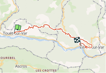
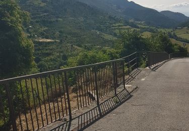
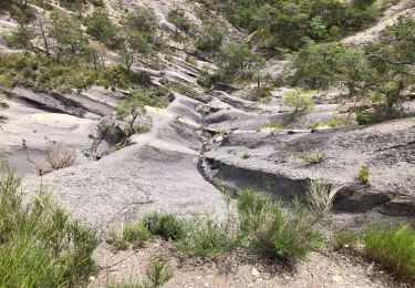
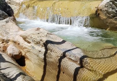
Randonnée A pied de 13,9 km à découvrir à Provence-Alpes-Côte d'Azur, Alpes-Maritimes, Touët-sur-Var. Cette randonnée est proposée par SityTrail - itinéraires balisés pédestres.
Description
Randonnée pédestre - Au départ de Touët-sur-Var, parking de la RD 6202 (340 m)
Site web: https://randoxygene.departement06.fr/moyen-var/traversee-touet-sur-var-villars-sur-var-9220.html
Localisation
Commentaires
Randonnées à proximité
![Randonnée Marche Rigaud - Mairola de Rigaud, chapelles St Julien et St Sauveur - Photo](https://media.geolcdn.com/t/375/260/bfd975e4-5b26-4452-b5c4-4e8903bf1886.jpg&format=jpg&maxdim=2)
![Marche Marche](https://static1.geolcdn.com/sitytour/trail-icons/101.png)
Marche
![](/images/other/stat-length.png)
![](https://static1.geolcdn.com/siteimages/upload/files/16400158638029165_repeat_loop_refresh_sync_direction_icon.png)
![Randonnée Marche Touët-sur-Var - Touet sur Var - Photo](https://media.geolcdn.com/t/375/260/591991c8-678f-43ce-bfb4-52a24dbc47c8.jpg&format=jpg&maxdim=2)
![Marche Marche](https://static1.geolcdn.com/sitytour/trail-icons/101.png)
Marche
![](/images/other/stat-length.png)
![](https://static1.geolcdn.com/siteimages/upload/files/16400158638029165_repeat_loop_refresh_sync_direction_icon.png)
![Randonnée Marche Thiéry - Brec d’ Ilonse - Photo](https://media.geolcdn.com/t/375/260/371e8790-f558-4bbf-8168-94a56f4b21b9.jpg&format=jpg&maxdim=2)
![Marche Marche](https://static1.geolcdn.com/sitytour/trail-icons/101.png)
Marche
![](/images/other/stat-length.png)
![](https://static1.geolcdn.com/siteimages/upload/files/16400158638029165_repeat_loop_refresh_sync_direction_icon.png)
![Randonnée Marche Thiéry - thiery Villa Soubere - Photo](https://media.geolcdn.com/t/375/260/152e54b1-7917-4f58-90c1-fbc432530c5c.jpg&format=jpg&maxdim=2)
![Marche Marche](https://static1.geolcdn.com/sitytour/trail-icons/101.png)
Marche
![](/images/other/stat-length.png)
![](https://static1.geolcdn.com/siteimages/upload/files/16400158638029165_repeat_loop_refresh_sync_direction_icon.png)
![Randonnée Marche Ascros - ascros - Photo](https://media.geolcdn.com/t/375/260/687f6507-142d-4d39-bc85-9162ba4808fa.jpg&format=jpg&maxdim=2)
![Marche Marche](https://static1.geolcdn.com/sitytour/trail-icons/101.png)
Marche
![](/images/other/stat-length.png)
![](https://static1.geolcdn.com/siteimages/upload/files/16400158638029165_repeat_loop_refresh_sync_direction_icon.png)
![Randonnée Marche Thiéry - mont fracha et brec d illons - Photo](https://media.geolcdn.com/t/375/260/7a352f20-95c8-4db5-abd7-afa376ae4d13.jpg&format=jpg&maxdim=2)
![Marche Marche](https://static1.geolcdn.com/sitytour/trail-icons/101.png)
Marche
![](/images/other/stat-length.png)
![](https://static1.geolcdn.com/siteimages/upload/files/16400158638029165_repeat_loop_refresh_sync_direction_icon.png)
![Vélo de route Vélo de route](https://static1.geolcdn.com/sitytour/trail-icons/201.png)
Vélo de route
![](/images/other/stat-length.png)
![](https://static1.geolcdn.com/siteimages/upload/files/16400158638029165_repeat_loop_refresh_sync_direction_icon.png)
![Randonnée Marche Thiéry - Le Brec d'Ilonse depuis Thiery - Photo](https://media.geolcdn.com/t/375/260/05ea1226-b0b0-47ac-8db3-3b64796c5f2e.jpg&format=jpg&maxdim=2)
![Marche Marche](https://static1.geolcdn.com/sitytour/trail-icons/101.png)
Marche
![](/images/other/stat-length.png)
![](https://static1.geolcdn.com/siteimages/upload/files/16400158638029165_repeat_loop_refresh_sync_direction_icon.png)
![Randonnée Marche Touët-sur-Var - Touet sur Var vers Villars sur Var - Photo](https://media.geolcdn.com/t/375/260/c65ee055-4789-4550-ac45-ad6e8bcc2469.jpg&format=jpg&maxdim=2)
![Marche Marche](https://static1.geolcdn.com/sitytour/trail-icons/101.png)
Marche
![](/images/other/stat-length.png)
![](https://static1.geolcdn.com/siteimages/upload/files/16400158638029165_repeat_loop_refresh_sync_direction_icon.png)