![](/images/other/stat-length.png)
![Randonnée A pied Tramont-Lassus - Circuit du Brénon - Photo](https://media.geolcdn.com/t/1900/400/4ed48376-052a-4a84-82e4-c9eb1071754e.jpeg&format=pjpeg&maxdim=2)
Circuit du Brénon
SityTrail - itinéraires balisés pédestres
Tous les sentiers balisés d’Europe GUIDE+
![Longueur](/images/other/stat-length.png)
Longueur
7,8 km
![Altitude max](https://static1.geolcdn.com/siteimages/upload/files/1508320355ic_sort_altitude_max_24dp.png)
Altitude max
476 m
![Dénivelé positif](https://static1.geolcdn.com/siteimages/upload/files/1508320355ic_sort_den_pos_24dp.png)
Dénivelé positif
177 m
![Km-Effort](/images/other/stat-length.png)
Km-Effort
10,2 km
![Altitude min](https://static1.geolcdn.com/siteimages/upload/files/1508320355ic_sort_altitude_min_24dp.png)
Altitude min
326 m
![Dénivelé négatif](https://static1.geolcdn.com/siteimages/upload/files/1508320355ic_sort_den_neg_24dp.png)
Dénivelé négatif
171 m
![Boucle](https://static1.geolcdn.com/siteimages/upload/files/16400158638029165_repeat_loop_refresh_sync_direction_icon.png)
Boucle
Non
Balise
Date de création :
2022-02-15 18:28:05.967
Dernière modification :
2022-03-02 21:02:20.647
![A pied](https://static1.geolcdn.com/sitytour/trail-icons/100.png)
2h18
Difficulté : Facile
![Scannez ce code QR pour ouvrir la randonnée dans l'application SityTrail](https://capi.geolives.com/qq0zvz2zws4bq2lad0pu/sitytour/trails/3123632/qr.png?size=200)
Application GPS de randonnée GRATUITE
À propos
Randonnée A pied de 7,8 km à découvrir à Grand Est, Meurthe-et-Moselle, Tramont-Lassus. Cette randonnée est proposée par SityTrail - itinéraires balisés pédestres.
Description
Randonnée créée par Association Intercommunale des Sentiers de la Mirabelle.
Localisation
Pays :
France
Région :
Grand Est
Département/Province :
Meurthe-et-Moselle
Commune :
Tramont-Lassus
Localité :
Unknown
Départ:(Dec)
Départ:(UTM)
720334 ; 5363864 (31U) N.
Commentaires
Randonnées à proximité
![Randonnée A pied Vandeléville - Sentier de la Vieille Chopine - Photo](https://media.geolcdn.com/t/375/260/9681fe6c-fb3d-4dc9-b479-8c06f3f169e6.jpeg&format=jpg&maxdim=2)
![A pied A pied](https://static1.geolcdn.com/sitytour/trail-icons/100.png)
Sentier de la Vieille Chopine
A pied
Facile
Vandeléville,
Grand Est,
Meurthe-et-Moselle,
France
![](/images/other/stat-length.png)
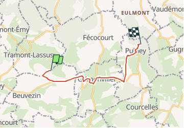
14,8 km | 19,1 km-effort
4h 19min
![](https://static1.geolcdn.com/siteimages/upload/files/16400158638029165_repeat_loop_refresh_sync_direction_icon.png)
Oui
![Randonnée Marche Vandeléville - bivouac lundi matin - Photo](https://media.geolcdn.com/t/375/260/ext.jpg?maxdim=2&url=https%3A%2F%2Fstatic1.geolcdn.com%2Fsiteimages%2Fupload%2Ffiles%2F1553511878bg_sport_marche.png)
![Marche Marche](https://static1.geolcdn.com/sitytour/trail-icons/101.png)
bivouac lundi matin
Marche
Facile
Vandeléville,
Grand Est,
Meurthe-et-Moselle,
France
![](/images/other/stat-length.png)
3,1 km | 3,6 km-effort
1h 37min
![](https://static1.geolcdn.com/siteimages/upload/files/16400158638029165_repeat_loop_refresh_sync_direction_icon.png)
Non
![Randonnée Marche Tramont-Émy - jour 2 alex - Photo](https://media.geolcdn.com/t/375/260/ext.jpg?maxdim=2&url=https%3A%2F%2Fstatic1.geolcdn.com%2Fsiteimages%2Fupload%2Ffiles%2F1553511878bg_sport_marche.png)
![Marche Marche](https://static1.geolcdn.com/sitytour/trail-icons/101.png)
jour 2 alex
Marche
Moyen
Tramont-Émy,
Grand Est,
Meurthe-et-Moselle,
France
![](/images/other/stat-length.png)
7,1 km | 8,5 km-effort
2h 27min
![](https://static1.geolcdn.com/siteimages/upload/files/16400158638029165_repeat_loop_refresh_sync_direction_icon.png)
Non
![Randonnée Randonnée équestre Courcelles - Hervé - Photo](https://media.geolcdn.com/t/375/260/ext.jpg?maxdim=2&url=https%3A%2F%2Fstatic1.geolcdn.com%2Fsiteimages%2Fupload%2Ffiles%2F1524743154cheval.jpg)
![Randonnée équestre Randonnée équestre](https://static1.geolcdn.com/sitytour/trail-icons/301.png)
Hervé
Randonnée équestre
Moyen
Courcelles,
Grand Est,
Meurthe-et-Moselle,
France
![](/images/other/stat-length.png)
14 km | 18,9 km-effort
3h 12min
![](https://static1.geolcdn.com/siteimages/upload/files/16400158638029165_repeat_loop_refresh_sync_direction_icon.png)
Oui
![Randonnée Marche Pulney - 19 05 14 Pulney - Photo](https://media.geolcdn.com/t/375/260/ext.jpg?maxdim=2&url=https%3A%2F%2Fstatic1.geolcdn.com%2Fsiteimages%2Fupload%2Ffiles%2F1553511878bg_sport_marche.png)
![Marche Marche](https://static1.geolcdn.com/sitytour/trail-icons/101.png)
19 05 14 Pulney
Marche
Très facile
Pulney,
Grand Est,
Meurthe-et-Moselle,
France
![](/images/other/stat-length.png)
15,8 km | 0 m-effort
5h 23min
![](https://static1.geolcdn.com/siteimages/upload/files/16400158638029165_repeat_loop_refresh_sync_direction_icon.png)
Oui
![Randonnée Marche Fécocourt - Fecocour - Photo](https://media.geolcdn.com/t/375/260/ext.jpg?maxdim=2&url=https%3A%2F%2Fstatic1.geolcdn.com%2Fsiteimages%2Fupload%2Ffiles%2F1553511878bg_sport_marche.png)
![Marche Marche](https://static1.geolcdn.com/sitytour/trail-icons/101.png)
Fecocour
Marche
Très facile
Fécocourt,
Grand Est,
Meurthe-et-Moselle,
France
![](/images/other/stat-length.png)
16,5 km | 22 km-effort
5h 9min
![](https://static1.geolcdn.com/siteimages/upload/files/16400158638029165_repeat_loop_refresh_sync_direction_icon.png)
Oui
![Randonnée Autre activité Vandeléville - 4ème rallye équestre favieres - Photo](https://media.geolcdn.com/t/375/260/ext.jpg?maxdim=2&url=https%3A%2F%2Fstatic1.geolcdn.com%2Fsiteimages%2Fupload%2Ffiles%2F1545311037marcheuse_200dpi.jpg)
![Autre activité Autre activité](https://static1.geolcdn.com/sitytour/trail-icons/900.png)
4ème rallye équestre favieres
Autre activité
Très facile
Vandeléville,
Grand Est,
Meurthe-et-Moselle,
France
![](/images/other/stat-length.png)
10 km | 12,5 km-effort
2h 9min
![](https://static1.geolcdn.com/siteimages/upload/files/16400158638029165_repeat_loop_refresh_sync_direction_icon.png)
Non