![](/images/other/stat-length.png)
![Randonnée A pied Brumano - Sentiero 576: Brumano - Passo La Porta - La Passata - Photo](https://media.geolcdn.com/t/1900/400/4eeb1c59-5b44-4f1b-a83f-dd9e672cf940.jpeg&format=pjpeg&maxdim=2)
Sentiero 576: Brumano - Passo La Porta - La Passata
SityTrail - itinéraires balisés pédestres
Tous les sentiers balisés d’Europe GUIDE+
![Longueur](/images/other/stat-length.png)
![Altitude max](https://static1.geolcdn.com/siteimages/upload/files/1508320355ic_sort_altitude_max_24dp.png)
![Dénivelé positif](https://static1.geolcdn.com/siteimages/upload/files/1508320355ic_sort_den_pos_24dp.png)
![Km-Effort](/images/other/stat-length.png)
![Altitude min](https://static1.geolcdn.com/siteimages/upload/files/1508320355ic_sort_altitude_min_24dp.png)
![Dénivelé négatif](https://static1.geolcdn.com/siteimages/upload/files/1508320355ic_sort_den_neg_24dp.png)
![Boucle](https://static1.geolcdn.com/siteimages/upload/files/16400158638029165_repeat_loop_refresh_sync_direction_icon.png)
![A pied](https://static1.geolcdn.com/sitytour/trail-icons/100.png)
1h41
Difficulté : Facile
![Scannez ce code QR pour ouvrir la randonnée dans l'application SityTrail](https://capi.geolives.com/qq0zvz2zws4bq2lad0pu/sitytour/trails/3123525/qr.png?size=200)
Application GPS de randonnée GRATUITE
À propos
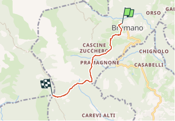
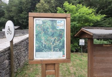
Randonnée A pied de 3,8 km à découvrir à Lombardie, Bergame, Brumano. Cette randonnée est proposée par SityTrail - itinéraires balisés pédestres.
Description
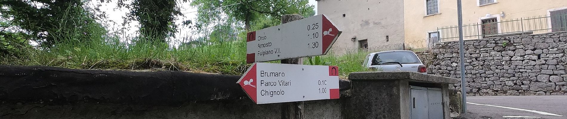
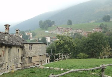
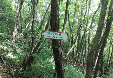
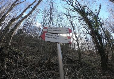
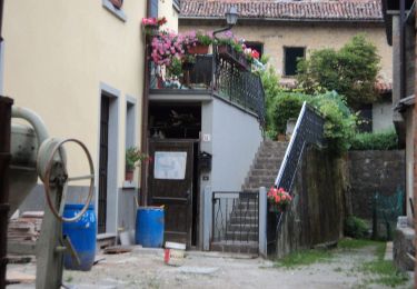
Dal parcheggio dopo il cimitero nei pressi della fontana si prende il sentiero alla sinistra della strada (nella prima parte è comune anche al sentiero 587), nei pressi di una valletta (916 m).
Site web: http://geoportale.caibergamo.it/it/sentiero/576
Localisation
Commentaires
Randonnées à proximité
![Randonnée A pied Erve - Sentiero 831: Cappella del Corno (Erve) - M. Spedone - Nesolio - Erve - Photo](https://media.geolcdn.com/t/375/260/c22af308-c393-4424-b1e9-a24d00feb4e3.jpeg&format=jpg&maxdim=2)
![A pied A pied](https://static1.geolcdn.com/sitytour/trail-icons/100.png)
A pied
![](/images/other/stat-length.png)
![](https://static1.geolcdn.com/siteimages/upload/files/16400158638029165_repeat_loop_refresh_sync_direction_icon.png)
![Randonnée A pied Corna Imagna - Sentiero del Castagno - Photo](https://media.geolcdn.com/t/375/260/e881095f-91fc-4410-85a2-fefec14e8daf.jpeg&format=jpg&maxdim=2)
![A pied A pied](https://static1.geolcdn.com/sitytour/trail-icons/100.png)
A pied
![](/images/other/stat-length.png)
![](https://static1.geolcdn.com/siteimages/upload/files/16400158638029165_repeat_loop_refresh_sync_direction_icon.png)
![Randonnée A pied Brumano - Sentiero 587: Brumano - Colletto di Brumano - Photo](https://media.geolcdn.com/t/375/260/d5220cad-47dc-402e-9f38-155ebf4f6518.jpeg&format=jpg&maxdim=2)
![A pied A pied](https://static1.geolcdn.com/sitytour/trail-icons/100.png)
A pied
![](/images/other/stat-length.png)
![](https://static1.geolcdn.com/siteimages/upload/files/16400158638029165_repeat_loop_refresh_sync_direction_icon.png)
![Randonnée A pied Rota d'Imagna - Sentiero 586: Rota d'Imagna - La Passata - Photo](https://media.geolcdn.com/t/375/260/6d394a27-a7f0-49ed-aec2-91bbd9475b1b.jpeg&format=jpg&maxdim=2)
![A pied A pied](https://static1.geolcdn.com/sitytour/trail-icons/100.png)
A pied
![](/images/other/stat-length.png)
![](https://static1.geolcdn.com/siteimages/upload/files/16400158638029165_repeat_loop_refresh_sync_direction_icon.png)
![Randonnée A pied Fuipiano Valle Imagna - Sentiero 580: Locatello - Tre Faggi - Photo](https://media.geolcdn.com/t/375/260/5f2fa99f-436b-4eb0-97ac-2ed6c38a09ca.jpeg&format=jpg&maxdim=2)
![A pied A pied](https://static1.geolcdn.com/sitytour/trail-icons/100.png)
A pied
![](/images/other/stat-length.png)
![](https://static1.geolcdn.com/siteimages/upload/files/16400158638029165_repeat_loop_refresh_sync_direction_icon.png)
![Randonnée A pied Brumano - Sentiero 579: Chignolo - Bocca del Grassello - Photo](https://media.geolcdn.com/t/375/260/b4453a2c-3703-4cd5-b203-ae74aa1a553c.jpeg&format=jpg&maxdim=2)
![A pied A pied](https://static1.geolcdn.com/sitytour/trail-icons/100.png)
A pied
![](/images/other/stat-length.png)
![](https://static1.geolcdn.com/siteimages/upload/files/16400158638029165_repeat_loop_refresh_sync_direction_icon.png)
![Randonnée A pied Sant'Omobono Terme - Sentiero 574: Valsecca - Pertüs - Photo](https://media.geolcdn.com/t/375/260/2ab6dc35-7a72-45e4-9d9e-f66156b77729.jpeg&format=jpg&maxdim=2)
![A pied A pied](https://static1.geolcdn.com/sitytour/trail-icons/100.png)
A pied
![](/images/other/stat-length.png)
![](https://static1.geolcdn.com/siteimages/upload/files/16400158638029165_repeat_loop_refresh_sync_direction_icon.png)
![Randonnée A pied Sant'Omobono Terme - Sentiero 573: Ca' Mazzoleni - Costa Imagna - Forcella Alta - Photo](https://media.geolcdn.com/t/375/260/a2dcbb35-124e-4567-8f9b-6877930f32cc.jpeg&format=jpg&maxdim=2)
![A pied A pied](https://static1.geolcdn.com/sitytour/trail-icons/100.png)
A pied
![](/images/other/stat-length.png)
![](https://static1.geolcdn.com/siteimages/upload/files/16400158638029165_repeat_loop_refresh_sync_direction_icon.png)
![Randonnée A pied Locatello - Sentiero dei Giganti - Photo](https://media.geolcdn.com/t/375/260/72123484-9394-4a25-a9d2-a3316a7f4d2e.jpeg&format=jpg&maxdim=2)
![A pied A pied](https://static1.geolcdn.com/sitytour/trail-icons/100.png)
A pied
![](/images/other/stat-length.png)
![](https://static1.geolcdn.com/siteimages/upload/files/16400158638029165_repeat_loop_refresh_sync_direction_icon.png)