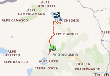
![](/images/other/stat-length.png)
![Randonnée A pied Antrona Schieranco - C32 - Forcola di Cheggio - Photo](https://media.geolcdn.com/t/1900/400/f03de3c7-65c8-450e-9cf9-dbfd39b89ed1.jpeg&format=pjpeg&maxdim=2)
C32 - Forcola di Cheggio
SityTrail - itinéraires balisés pédestres
Tous les sentiers balisés d’Europe GUIDE+
![Longueur](/images/other/stat-length.png)
![Altitude max](https://static1.geolcdn.com/siteimages/upload/files/1508320355ic_sort_altitude_max_24dp.png)
![Dénivelé positif](https://static1.geolcdn.com/siteimages/upload/files/1508320355ic_sort_den_pos_24dp.png)
![Km-Effort](/images/other/stat-length.png)
![Altitude min](https://static1.geolcdn.com/siteimages/upload/files/1508320355ic_sort_altitude_min_24dp.png)
![Dénivelé négatif](https://static1.geolcdn.com/siteimages/upload/files/1508320355ic_sort_den_neg_24dp.png)
![Boucle](https://static1.geolcdn.com/siteimages/upload/files/16400158638029165_repeat_loop_refresh_sync_direction_icon.png)
![A pied](https://static1.geolcdn.com/sitytour/trail-icons/100.png)
3h22
Difficulté : Facile
![Scannez ce code QR pour ouvrir la randonnée dans l'application SityTrail](https://capi.geolives.com/qq0zvz2zws4bq2lad0pu/sitytour/trails/3123399/qr.png?size=200)
Application GPS de randonnée GRATUITE
À propos
Randonnée A pied de 5,2 km à découvrir à Piémont, Verbano-Cusio-Ossola, Antrona Schieranco. Cette randonnée est proposée par SityTrail - itinéraires balisés pédestres.
Description
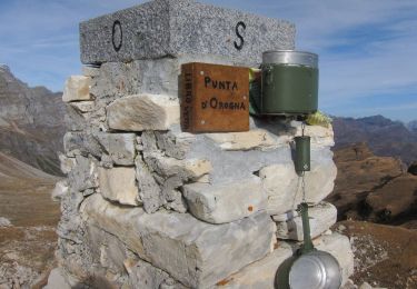
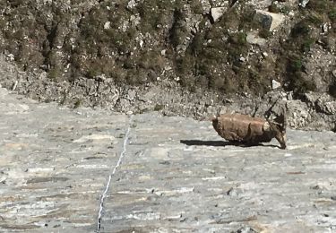
Relation with photos (click on → Web site) mantained by CAI Sezioni Est Monterosa
Symbole: white red flags
Site web: http://www.comune.antronaschieranco.vb.it
Localisation
Commentaires
Randonnées à proximité
![Randonnée A pied Antrona Schieranco - C34 - Lago di Campliccioli - Lago di Camposecco - Photo](https://media.geolcdn.com/t/375/260/a3fb9a62-828a-4a1f-906b-e9b1d868c018.jpeg&format=jpg&maxdim=2)
![A pied A pied](https://static1.geolcdn.com/sitytour/trail-icons/100.png)
A pied
![](/images/other/stat-length.png)
![](https://static1.geolcdn.com/siteimages/upload/files/16400158638029165_repeat_loop_refresh_sync_direction_icon.png)
![Randonnée A pied Antrona Schieranco - C23 - Campliccioli, bivio C00 - Alpe Lombraoro sotto, bivio C00 - Photo](https://media.geolcdn.com/t/375/260/a685f981-f3a3-4056-bed4-c124840e7a84.jpeg&format=jpg&maxdim=2)
![A pied A pied](https://static1.geolcdn.com/sitytour/trail-icons/100.png)
A pied
![](/images/other/stat-length.png)
![](https://static1.geolcdn.com/siteimages/upload/files/16400158638029165_repeat_loop_refresh_sync_direction_icon.png)
![Randonnée A pied Antrona Schieranco - C00 - Strada Antronesca tappa 2 - Photo](https://media.geolcdn.com/t/375/260/b43783fe-69f5-48e6-8d34-cf6fddfe72b1.jpeg&format=jpg&maxdim=2)
![A pied A pied](https://static1.geolcdn.com/sitytour/trail-icons/100.png)
A pied
![](/images/other/stat-length.png)
![](https://static1.geolcdn.com/siteimages/upload/files/16400158638029165_repeat_loop_refresh_sync_direction_icon.png)
![Randonnée A pied Antrona Schieranco - (SI E52N) Bivacco Cingino - Rifugio Andolla - Photo](https://media.geolcdn.com/t/375/260/1b896175-672b-4b1c-88f1-b6cb7c4ab1ed.jpeg&format=jpg&maxdim=2)
![A pied A pied](https://static1.geolcdn.com/sitytour/trail-icons/100.png)
A pied
![](/images/other/stat-length.png)
![](https://static1.geolcdn.com/siteimages/upload/files/16400158638029165_repeat_loop_refresh_sync_direction_icon.png)
![Randonnée A pied Antrona Schieranco - C00 - Strada Antronesca tappa 3 - Photo](https://media.geolcdn.com/t/375/260/7718e937-08ec-4782-8313-4e166eb34037.jpeg&format=jpg&maxdim=2)
![A pied A pied](https://static1.geolcdn.com/sitytour/trail-icons/100.png)
A pied
![](/images/other/stat-length.png)
![](https://static1.geolcdn.com/siteimages/upload/files/16400158638029165_repeat_loop_refresh_sync_direction_icon.png)
![Randonnée A pied Antrona Schieranco - C27 - Antronapiana - Bivio C99 (Coronette) - Photo](https://media.geolcdn.com/t/375/260/db5854fd-6672-4dbe-a7a1-dbe0775b01f9.jpeg&format=jpg&maxdim=2)
![A pied A pied](https://static1.geolcdn.com/sitytour/trail-icons/100.png)
A pied
![](/images/other/stat-length.png)
![](https://static1.geolcdn.com/siteimages/upload/files/16400158638029165_repeat_loop_refresh_sync_direction_icon.png)
![Randonnée A pied Antrona Schieranco - (SI E56) Rifugio Città di Novara all'Alpe Cheggio - Rifugio Alpe Laghetto - Photo](https://media.geolcdn.com/t/375/260/287e5399-3c97-472c-8e2e-47aa98750a7e.jpeg&format=jpg&maxdim=2)
![A pied A pied](https://static1.geolcdn.com/sitytour/trail-icons/100.png)
A pied
![](/images/other/stat-length.png)
![](https://static1.geolcdn.com/siteimages/upload/files/16400158638029165_repeat_loop_refresh_sync_direction_icon.png)
![Randonnée A pied Antrona Schieranco - (SI E53N) Rifugio Andolla - Rifugio Alpe Laghetto - Photo](https://media.geolcdn.com/t/375/260/287e5399-3c97-472c-8e2e-47aa98750a7e.jpeg&format=jpg&maxdim=2)
![A pied A pied](https://static1.geolcdn.com/sitytour/trail-icons/100.png)
A pied
![](/images/other/stat-length.png)
![](https://static1.geolcdn.com/siteimages/upload/files/16400158638029165_repeat_loop_refresh_sync_direction_icon.png)
![Randonnée Marche Antrona Schieranco - antrona - Photo](https://media.geolcdn.com/t/375/260/ext.jpg?maxdim=2&url=https%3A%2F%2Fservices.sitytrail.com%2FGeolivesWS%2FDownloadMedia.ashx%3FTrailID%3D833577%26Media%3Dfix__20170922150827.jpg)
![Marche Marche](https://static1.geolcdn.com/sitytour/trail-icons/101.png)
Marche
![](/images/other/stat-length.png)
![](https://static1.geolcdn.com/siteimages/upload/files/16400158638029165_repeat_loop_refresh_sync_direction_icon.png)