![](/images/other/stat-length.png)
![Randonnée A pied Marradi - L'Acquacheta e l'Alto Tramazzo - Photo](https://media.geolcdn.com/t/1900/400/ext.pjpeg?maxdim=2&url=https%3A%2F%2Fupload.wikimedia.org%2Fwikipedia%2Fcommons%2Fthumb%2Fb%2Fb4%2FParco_nazionale_delle_Foreste_Casentinesi_%252801%2529.jpg%2F2000px-Parco_nazionale_delle_Foreste_Casentinesi_%252801%2529.jpg)
L'Acquacheta e l'Alto Tramazzo
SityTrail - itinéraires balisés pédestres
Tous les sentiers balisés d’Europe GUIDE+
![Longueur](/images/other/stat-length.png)
![Altitude max](https://static1.geolcdn.com/siteimages/upload/files/1508320355ic_sort_altitude_max_24dp.png)
![Dénivelé positif](https://static1.geolcdn.com/siteimages/upload/files/1508320355ic_sort_den_pos_24dp.png)
![Km-Effort](/images/other/stat-length.png)
![Altitude min](https://static1.geolcdn.com/siteimages/upload/files/1508320355ic_sort_altitude_min_24dp.png)
![Dénivelé négatif](https://static1.geolcdn.com/siteimages/upload/files/1508320355ic_sort_den_neg_24dp.png)
![Boucle](https://static1.geolcdn.com/siteimages/upload/files/16400158638029165_repeat_loop_refresh_sync_direction_icon.png)
![A pied](https://static1.geolcdn.com/sitytour/trail-icons/100.png)
3h41
Difficulté : Facile
![Scannez ce code QR pour ouvrir la randonnée dans l'application SityTrail](https://capi.geolives.com/qq0zvz2zws4bq2lad0pu/sitytour/trails/3122861/qr.png?size=200)
Application GPS de randonnée GRATUITE
À propos
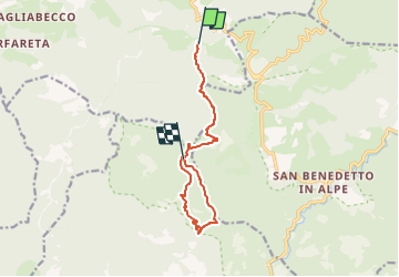
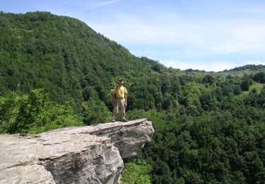
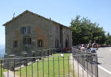
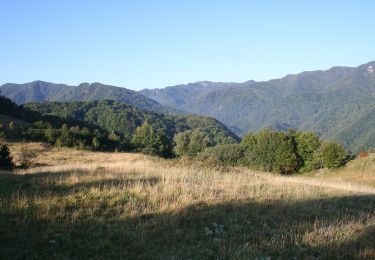
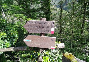
Randonnée A pied de 10 km à découvrir à Toscane, Firenze, Marradi. Cette randonnée est proposée par SityTrail - itinéraires balisés pédestres.
Description
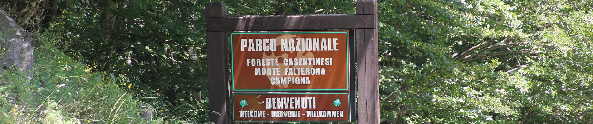
Il Parco nazionale delle Foreste Casentinesi, Monte Falterona e Campigna è stato istituito nel 1993 ed è situato nell'Appennino tosco-romagnolo, tra le province di Forlì-Cesena, di Arezzo e di Firenze.
Site web: https://www.parcoforestecasentinesi.it
Localisation
Commentaires
Randonnées à proximité
![Randonnée A pied Marradi - L’Acquacheta e il Monte Lavane - Photo](https://media.geolcdn.com/t/375/260/73c97019-1353-4905-9a28-67cb30531393.jpeg&format=jpg&maxdim=2)
![A pied A pied](https://static1.geolcdn.com/sitytour/trail-icons/100.png)
A pied
![](/images/other/stat-length.png)
![](https://static1.geolcdn.com/siteimages/upload/files/16400158638029165_repeat_loop_refresh_sync_direction_icon.png)
![Randonnée A pied Portico e San Benedetto - L’anello classico dell’Acquacheta - Photo](https://media.geolcdn.com/t/375/260/e0e65af1-b08c-4714-9518-f040c77653ce.jpeg&format=jpg&maxdim=2)
![A pied A pied](https://static1.geolcdn.com/sitytour/trail-icons/100.png)
A pied
![](/images/other/stat-length.png)
![](https://static1.geolcdn.com/siteimages/upload/files/16400158638029165_repeat_loop_refresh_sync_direction_icon.png)
![Randonnée A pied Portico e San Benedetto - Tra i giganti della Val Tramazzo - Photo](https://media.geolcdn.com/t/375/260/ff2fdc6b-7a3c-4e1d-8ca2-846b130f5ad3.jpeg&format=jpg&maxdim=2)
![A pied A pied](https://static1.geolcdn.com/sitytour/trail-icons/100.png)
A pied
![](/images/other/stat-length.png)
![](https://static1.geolcdn.com/siteimages/upload/files/16400158638029165_repeat_loop_refresh_sync_direction_icon.png)
![Randonnée A pied Tredozio - L’Acquacheta e l’Alto Montone - Photo](https://media.geolcdn.com/t/375/260/130d3e21-ebaa-4aab-ad63-5ee7456f7c76.jpeg&format=jpg&maxdim=2)
![A pied A pied](https://static1.geolcdn.com/sitytour/trail-icons/100.png)
A pied
![](/images/other/stat-length.png)
![](https://static1.geolcdn.com/siteimages/upload/files/16400158638029165_repeat_loop_refresh_sync_direction_icon.png)
![Randonnée A pied Marradi - IT-501 - Photo](https://media.geolcdn.com/t/375/260/a2d8eaba-d795-4e7f-9a08-00b864a5c67a.jpeg&format=jpg&maxdim=2)
![A pied A pied](https://static1.geolcdn.com/sitytour/trail-icons/100.png)
![Randonnée A pied San Godenzo - Sentiero Natura Acquacheta - Photo](https://media.geolcdn.com/t/375/260/c8ebfc66-ef46-49ea-beb1-6eb8f9fabe57.jpeg&format=jpg&maxdim=2)
![A pied A pied](https://static1.geolcdn.com/sitytour/trail-icons/100.png)
A pied
![](/images/other/stat-length.png)
![](https://static1.geolcdn.com/siteimages/upload/files/16400158638029165_repeat_loop_refresh_sync_direction_icon.png)
![Randonnée A pied Portico e San Benedetto - IT-427 - Photo](https://media.geolcdn.com/t/375/260/c8ebfc66-ef46-49ea-beb1-6eb8f9fabe57.jpeg&format=jpg&maxdim=2)
![A pied A pied](https://static1.geolcdn.com/sitytour/trail-icons/100.png)
A pied
![](/images/other/stat-length.png)
![](https://static1.geolcdn.com/siteimages/upload/files/16400158638029165_repeat_loop_refresh_sync_direction_icon.png)
![Randonnée A pied Tredozio - IT-565 - Photo](https://media.geolcdn.com/t/375/260/597a9649-eb40-4e02-b5bc-c9bebd6c184e.jpeg&format=jpg&maxdim=2)
![A pied A pied](https://static1.geolcdn.com/sitytour/trail-icons/100.png)
A pied
![](/images/other/stat-length.png)
![](https://static1.geolcdn.com/siteimages/upload/files/16400158638029165_repeat_loop_refresh_sync_direction_icon.png)
![Randonnée A pied Portico e San Benedetto - IT-555 - Photo](https://media.geolcdn.com/t/375/260/a2d8eaba-d795-4e7f-9a08-00b864a5c67a.jpeg&format=jpg&maxdim=2)
![A pied A pied](https://static1.geolcdn.com/sitytour/trail-icons/100.png)
A pied
![](/images/other/stat-length.png)
![](https://static1.geolcdn.com/siteimages/upload/files/16400158638029165_repeat_loop_refresh_sync_direction_icon.png)