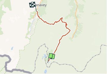
![](/images/other/stat-length.png)
![Randonnée A pied Valsavarenche - (SI F01) 
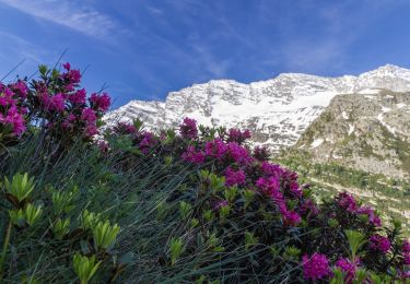
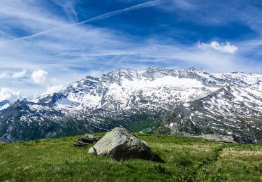
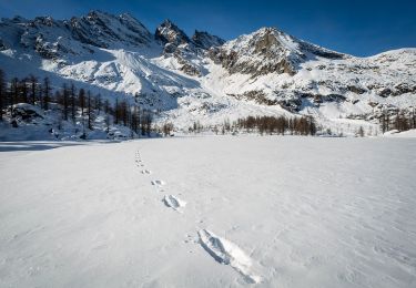
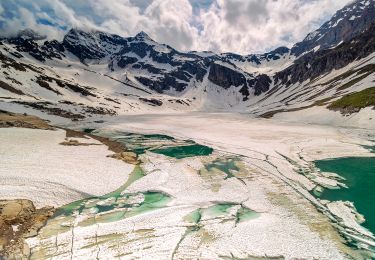
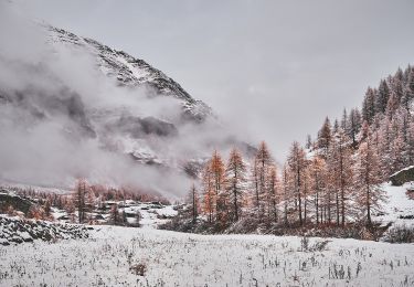
Rifugio Savoia - Rhêmes-Notre-Dame - Photo](https://media.geolcdn.com/t/1900/400/a8a7705e-8995-46b0-a00f-d0c62a3e946c.jpeg&format=pjpeg&maxdim=2)
(SI F01) Rifugio Savoia - Rhêmes-Notre-Dame
SityTrail - itinéraires balisés pédestres
Tous les sentiers balisés d’Europe GUIDE+
![Longueur](/images/other/stat-length.png)
Longueur
21 km
![Altitude max](https://static1.geolcdn.com/siteimages/upload/files/1508320355ic_sort_altitude_max_24dp.png)
Altitude max
3003 m
![Dénivelé positif](https://static1.geolcdn.com/siteimages/upload/files/1508320355ic_sort_den_pos_24dp.png)
Dénivelé positif
899 m
![Km-Effort](/images/other/stat-length.png)
Km-Effort
35 km
![Altitude min](https://static1.geolcdn.com/siteimages/upload/files/1508320355ic_sort_altitude_min_24dp.png)
Altitude min
1727 m
![Dénivelé négatif](https://static1.geolcdn.com/siteimages/upload/files/1508320355ic_sort_den_neg_24dp.png)
Dénivelé négatif
1706 m
![Boucle](https://static1.geolcdn.com/siteimages/upload/files/16400158638029165_repeat_loop_refresh_sync_direction_icon.png)
Boucle
Non
Balise
Date de création :
2022-02-15 16:36:10.408
Dernière modification :
2022-03-01 19:14:18.203
![A pied](https://static1.geolcdn.com/sitytour/trail-icons/100.png)
8h03
Difficulté : Difficile
![Scannez ce code QR pour ouvrir la randonnée dans l'application SityTrail](https://capi.geolives.com/qq0zvz2zws4bq2lad0pu/sitytour/trails/3121876/qr.png?size=200)
Application GPS de randonnée GRATUITE
À propos
Randonnée A pied de 21 km à découvrir à Vallée d'Aoste, Inconnu, Valsavarenche. Cette randonnée est proposée par SityTrail - itinéraires balisés pédestres.
Description
Randonnée créée par Club Alpino Italiano.
Sentiero Italia CAI 2019
Localisation
Pays :
Italie
Région :
Vallée d'Aoste
Département/Province :
Inconnu
Commune :
Valsavarenche
Localité :
Unknown
Départ:(Dec)
Départ:(UTM)
354923 ; 5038563 (32T) N.
Commentaires
Randonnées à proximité
![Randonnée A pied Ceresole Reale - IT-550 - Photo](https://media.geolcdn.com/t/375/260/7b4dbd86-f2a1-48cd-8ff5-50b543f4699d.jpeg&format=jpg&maxdim=2)
![A pied A pied](https://static1.geolcdn.com/sitytour/trail-icons/100.png)
![Randonnée A pied Ceresole Reale - IT-537 - Photo](https://media.geolcdn.com/t/375/260/66732a71-183a-4769-b3b0-caea161df0d3.jpeg&format=jpg&maxdim=2)
![A pied A pied](https://static1.geolcdn.com/sitytour/trail-icons/100.png)
![Randonnée A pied Valsavarenche - IT-3A - Photo](https://media.geolcdn.com/t/375/260/8c855fcd-8b0a-451a-a58f-32911e440748.jpeg&format=jpg&maxdim=2)
![A pied A pied](https://static1.geolcdn.com/sitytour/trail-icons/100.png)
IT-3A
A pied
Facile
Valsavarenche,
Vallée d'Aoste,
Inconnu,
Italie
![](/images/other/stat-length.png)
3,4 km | 10 km-effort
2h 16min
![](https://static1.geolcdn.com/siteimages/upload/files/16400158638029165_repeat_loop_refresh_sync_direction_icon.png)
Non
![Randonnée A pied Ceresole Reale - IT-540 - Photo](https://media.geolcdn.com/t/375/260/7b4dbd86-f2a1-48cd-8ff5-50b543f4699d.jpeg&format=jpg&maxdim=2)
![A pied A pied](https://static1.geolcdn.com/sitytour/trail-icons/100.png)
![Randonnée A pied Ceresole Reale - 3C, Col Rosset - Photo](https://media.geolcdn.com/t/375/260/ba122b33-dd1b-4db3-af23-e0f7f9ede187.jpeg&format=jpg&maxdim=2)
![A pied A pied](https://static1.geolcdn.com/sitytour/trail-icons/100.png)
3C, Col Rosset
A pied
Facile
Ceresole Reale,
Piémont,
Turin,
Italie
![](/images/other/stat-length.png)
4,9 km | 6,6 km-effort
1h 29min
![](https://static1.geolcdn.com/siteimages/upload/files/16400158638029165_repeat_loop_refresh_sync_direction_icon.png)
Non
![Randonnée A pied Ceresole Reale - IT-532 - Photo](https://media.geolcdn.com/t/375/260/66732a71-183a-4769-b3b0-caea161df0d3.jpeg&format=jpg&maxdim=2)
![A pied A pied](https://static1.geolcdn.com/sitytour/trail-icons/100.png)
![Randonnée A pied Ceresole Reale - IT-539 - Photo](https://media.geolcdn.com/t/375/260/bfe63c08-3059-41a0-97b0-a79611fb2f31.jpeg&format=jpg&maxdim=2)
![A pied A pied](https://static1.geolcdn.com/sitytour/trail-icons/100.png)
![Randonnée A pied Ceresole Reale - IT-529 - Photo](https://media.geolcdn.com/t/375/260/66732a71-183a-4769-b3b0-caea161df0d3.jpeg&format=jpg&maxdim=2)
![A pied A pied](https://static1.geolcdn.com/sitytour/trail-icons/100.png)
![Randonnée A pied Ceresole Reale - IT-531A - Photo](https://media.geolcdn.com/t/375/260/2699b8df-e6df-42c5-8c2d-c73ed3a6cefd.jpeg&format=jpg&maxdim=2)
![A pied A pied](https://static1.geolcdn.com/sitytour/trail-icons/100.png)