![](/images/other/stat-length.png)
![Randonnée A pied Cergy - Le Fil d'Ariane - Photo](https://media.geolcdn.com/t/1900/400/99555ae7-7473-4890-8cc1-181c61a69de2.jpeg&format=pjpeg&maxdim=2)
Le Fil d'Ariane
SityTrail - itinéraires balisés pédestres
Tous les sentiers balisés d’Europe GUIDE+
![Longueur](/images/other/stat-length.png)
Longueur
3,2 km
![Altitude max](https://static1.geolcdn.com/siteimages/upload/files/1508320355ic_sort_altitude_max_24dp.png)
Altitude max
96 m
![Dénivelé positif](https://static1.geolcdn.com/siteimages/upload/files/1508320355ic_sort_den_pos_24dp.png)
Dénivelé positif
50 m
![Km-Effort](/images/other/stat-length.png)
Km-Effort
3,7 km
![Altitude min](https://static1.geolcdn.com/siteimages/upload/files/1508320355ic_sort_altitude_min_24dp.png)
Altitude min
47 m
![Dénivelé négatif](https://static1.geolcdn.com/siteimages/upload/files/1508320355ic_sort_den_neg_24dp.png)
Dénivelé négatif
3 m
![Boucle](https://static1.geolcdn.com/siteimages/upload/files/16400158638029165_repeat_loop_refresh_sync_direction_icon.png)
Boucle
Non
Balise
Date de création :
2022-02-15 16:26:17.622
Dernière modification :
2022-03-02 18:34:10.784
![A pied](https://static1.geolcdn.com/sitytour/trail-icons/100.png)
50m
Difficulté : Facile
![Scannez ce code QR pour ouvrir la randonnée dans l'application SityTrail](https://capi.geolives.com/qq0zvz2zws4bq2lad0pu/sitytour/trails/3121661/qr.png?size=200)
Application GPS de randonnée GRATUITE
À propos
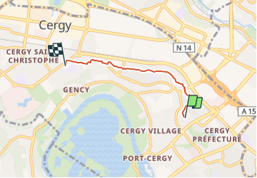
Randonnée A pied de 3,2 km à découvrir à Île-de-France, Val-d'Oise, Cergy. Cette randonnée est proposée par SityTrail - itinéraires balisés pédestres.
Description
Randonnée créée par Office de Tourisme de Cergy-Pontoise - Porte du Vexin.
Site web: http://www.cergy.fr/uploads/media/circuit-fil-d-ariane-cergy.pdf
Localisation
Pays :
France
Région :
Île-de-France
Département/Province :
Val-d'Oise
Commune :
Cergy
Localité :
Unknown
Départ:(Dec)
Départ:(UTM)
432044 ; 5432092 (31U) N.
Commentaires
Randonnées à proximité
![Randonnée Marche Pontoise - GRP CV-IDF 06R Pontoise à Frépillon - Photo](https://media.geolcdn.com/t/375/260/5cecfad9-3425-44be-8077-e3aed6f072e1.jpg&format=jpg&maxdim=2)
![Marche Marche](https://static1.geolcdn.com/sitytour/trail-icons/101.png)
GRP CV-IDF 06R Pontoise à Frépillon
Marche
Difficile
(1)
Pontoise,
Île-de-France,
Val-d'Oise,
France
![](/images/other/stat-length.png)
15,3 km | 18,6 km-effort
4h 13min
![](https://static1.geolcdn.com/siteimages/upload/files/16400158638029165_repeat_loop_refresh_sync_direction_icon.png)
Non
![Randonnée Marche Jouy-le-Moutier - GRP CV-IDF 05R Jouy-le-Moutier à Pontoise - Photo](https://media.geolcdn.com/t/375/260/6d7dbb85-8194-44c4-a991-493315d817a9.jpg&format=jpg&maxdim=2)
![Marche Marche](https://static1.geolcdn.com/sitytour/trail-icons/101.png)
GRP CV-IDF 05R Jouy-le-Moutier à Pontoise
Marche
Difficile
(1)
Jouy-le-Moutier,
Île-de-France,
Val-d'Oise,
France
![](/images/other/stat-length.png)
15,6 km | 18 km-effort
4h 4min
![](https://static1.geolcdn.com/siteimages/upload/files/16400158638029165_repeat_loop_refresh_sync_direction_icon.png)
Non
![Randonnée Course à pied Cergy - Les Bords de l'Oise et la Passerelle de l'Axe Majeur - Port Cergy - Photo](https://media.geolcdn.com/t/375/260/ext.jpg?maxdim=2&url=https%3A%2F%2Fservices.sitytrail.com%2FGeolivesWS%2FDownloadMedia.ashx%3FTrailID%3D118750%26Media%3D12946_6.jpg)
![Course à pied Course à pied](https://static1.geolcdn.com/sitytour/trail-icons/103.png)
Les Bords de l'Oise et la Passerelle de l'Axe Majeur - Port Cergy
Course à pied
Facile
(1)
Cergy,
Île-de-France,
Val-d'Oise,
France
![](/images/other/stat-length.png)
5,2 km | 5,8 km-effort
30min
![](https://static1.geolcdn.com/siteimages/upload/files/16400158638029165_repeat_loop_refresh_sync_direction_icon.png)
Oui
![Randonnée A pied Cergy - LES BALADES DE L’ÉTÉ # 9 / DE L’AXE MAJEUR À PORT CERGY - Photo](https://media.geolcdn.com/t/375/260/0abd8c0c-1f20-444a-8fa9-27c91da3cbd0.jpeg&format=jpg&maxdim=2)
![A pied A pied](https://static1.geolcdn.com/sitytour/trail-icons/100.png)
LES BALADES DE L’ÉTÉ # 9 / DE L’AXE MAJEUR À PORT CERGY
A pied
Très facile
(1)
Cergy,
Île-de-France,
Val-d'Oise,
France
![](/images/other/stat-length.png)
6 km | 7,4 km-effort
1h 45min
![](https://static1.geolcdn.com/siteimages/upload/files/16400158638029165_repeat_loop_refresh_sync_direction_icon.png)
Oui
![Randonnée Marche Pontoise - Le tour du grand Paris via le GR1 Etape 5 Pontoise- L'isle Adam - Photo](https://media.geolcdn.com/t/375/260/07b6ba80-b018-4e04-a1a3-6a0196965773.jpg&format=jpg&maxdim=2)
![Marche Marche](https://static1.geolcdn.com/sitytour/trail-icons/101.png)
Le tour du grand Paris via le GR1 Etape 5 Pontoise- L'isle Adam
Marche
Moyen
Pontoise,
Île-de-France,
Val-d'Oise,
France
![](/images/other/stat-length.png)
32 km | 38 km-effort
6h 40min
![](https://static1.geolcdn.com/siteimages/upload/files/16400158638029165_repeat_loop_refresh_sync_direction_icon.png)
Non
![Randonnée A pied Cergy - Bords d'Oise Eragny - Port Cergy - Photo](https://media.geolcdn.com/t/375/260/b35f55a1-55cf-41a0-a75c-3f85248a60dd.jpeg&format=jpg&maxdim=2)
![A pied A pied](https://static1.geolcdn.com/sitytour/trail-icons/100.png)
Bords d'Oise Eragny - Port Cergy
A pied
Très facile
(1)
Cergy,
Île-de-France,
Val-d'Oise,
France
![](/images/other/stat-length.png)
8 km | 8,7 km-effort
2h 0min
![](https://static1.geolcdn.com/siteimages/upload/files/16400158638029165_repeat_loop_refresh_sync_direction_icon.png)
Oui
![Randonnée Marche Neuville-sur-Oise - base losir cergy - Photo](https://media.geolcdn.com/t/375/260/ext.jpg?maxdim=2&url=https%3A%2F%2Fstatic1.geolcdn.com%2Fsiteimages%2Fupload%2Ffiles%2F1553511878bg_sport_marche.png)
![Marche Marche](https://static1.geolcdn.com/sitytour/trail-icons/101.png)
base losir cergy
Marche
Moyen
(1)
Neuville-sur-Oise,
Île-de-France,
Val-d'Oise,
France
![](/images/other/stat-length.png)
22 km | 26 km-effort
5h 35min
![](https://static1.geolcdn.com/siteimages/upload/files/16400158638029165_repeat_loop_refresh_sync_direction_icon.png)
Non
![Randonnée Marche Boissy-l'Aillerie - La chaussée Jules César - Photo](https://media.geolcdn.com/t/375/260/ext.jpg?maxdim=2&url=https%3A%2F%2Fstatic1.geolcdn.com%2Fsiteimages%2Fupload%2Ffiles%2F1553511878bg_sport_marche.png)
![Marche Marche](https://static1.geolcdn.com/sitytour/trail-icons/101.png)
La chaussée Jules César
Marche
Très facile
(2)
Boissy-l'Aillerie,
Île-de-France,
Val-d'Oise,
France
![](/images/other/stat-length.png)
10,9 km | 13,9 km-effort
Inconnu
![](https://static1.geolcdn.com/siteimages/upload/files/16400158638029165_repeat_loop_refresh_sync_direction_icon.png)
Oui
![Randonnée Marche Osny - Osny chateau chateau Groussy - Photo](https://media.geolcdn.com/t/375/260/2cb76fcb-9d9e-4863-81f3-8638303ac17e.jpg&format=jpg&maxdim=2)
![Marche Marche](https://static1.geolcdn.com/sitytour/trail-icons/101.png)
Osny chateau chateau Groussy
Marche
Facile
Osny,
Île-de-France,
Val-d'Oise,
France
![](/images/other/stat-length.png)
11,1 km | 12,9 km-effort
3h 3min
![](https://static1.geolcdn.com/siteimages/upload/files/16400158638029165_repeat_loop_refresh_sync_direction_icon.png)
Oui