![](/images/other/stat-length.png)
![Randonnée A pied San Venanzo - Anello Elmo - Photo](https://media.geolcdn.com/t/1900/400/2581411b-84d3-4f21-8e54-3bfe578c87bf.jpeg&format=pjpeg&maxdim=2)
Anello Elmo
SityTrail - itinéraires balisés pédestres
Tous les sentiers balisés d’Europe GUIDE+
![Longueur](/images/other/stat-length.png)
Longueur
7,9 km
![Altitude max](https://static1.geolcdn.com/siteimages/upload/files/1508320355ic_sort_altitude_max_24dp.png)
Altitude max
534 m
![Dénivelé positif](https://static1.geolcdn.com/siteimages/upload/files/1508320355ic_sort_den_pos_24dp.png)
Dénivelé positif
417 m
![Km-Effort](/images/other/stat-length.png)
Km-Effort
13,5 km
![Altitude min](https://static1.geolcdn.com/siteimages/upload/files/1508320355ic_sort_altitude_min_24dp.png)
Altitude min
185 m
![Dénivelé négatif](https://static1.geolcdn.com/siteimages/upload/files/1508320355ic_sort_den_neg_24dp.png)
Dénivelé négatif
421 m
![Boucle](https://static1.geolcdn.com/siteimages/upload/files/16400158638029165_repeat_loop_refresh_sync_direction_icon.png)
Boucle
Oui
Balise
Date de création :
2022-02-15 15:49:23.913
Dernière modification :
2022-03-01 16:35:37.703
![A pied](https://static1.geolcdn.com/sitytour/trail-icons/100.png)
3h03
Difficulté : Facile
![Scannez ce code QR pour ouvrir la randonnée dans l'application SityTrail](https://capi.geolives.com/qq0zvz2zws4bq2lad0pu/sitytour/trails/3121058/qr.png?size=200)
Application GPS de randonnée GRATUITE
À propos
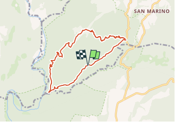
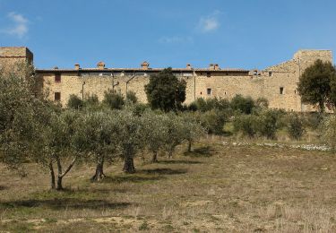
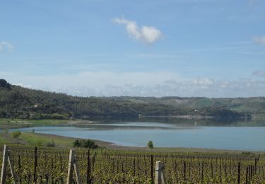
Randonnée A pied de 7,9 km à découvrir à Ombrie, Terni, San Venanzo. Cette randonnée est proposée par SityTrail - itinéraires balisés pédestres.
Description
Randonnée créée par Sistema Territoriale di Interesse Naturalistico Ambientale (S.T.I.N.A.).
Localisation
Pays :
Italie
Région :
Ombrie
Département/Province :
Terni
Commune :
San Venanzo
Localité :
Unknown
Départ:(Dec)
Départ:(UTM)
266677 ; 4743652 (33T) N.
Commentaires
Randonnées à proximité
![Randonnée A pied Allerona - Anello orvietano - Photo](https://media.geolcdn.com/t/375/260/1174a806-5c21-4731-a235-0ee9bbf6bc9e.jpeg&format=jpg&maxdim=2)
![A pied A pied](https://static1.geolcdn.com/sitytour/trail-icons/100.png)
Anello orvietano
A pied
Très difficile
Allerona,
Ombrie,
Terni,
Italie
![](/images/other/stat-length.png)
178 km | 249 km-effort
56h 34min
![](https://static1.geolcdn.com/siteimages/upload/files/16400158638029165_repeat_loop_refresh_sync_direction_icon.png)
Oui
![Randonnée A pied Allerona - Anello Villa Cahen - Photo](https://media.geolcdn.com/t/375/260/0b79a6f7-bfa0-4866-952a-519d3559d797.jpeg&format=jpg&maxdim=2)
![A pied A pied](https://static1.geolcdn.com/sitytour/trail-icons/100.png)
Anello Villa Cahen
A pied
Facile
Allerona,
Ombrie,
Terni,
Italie
![](/images/other/stat-length.png)
9,7 km | 13,8 km-effort
3h 7min
![](https://static1.geolcdn.com/siteimages/upload/files/16400158638029165_repeat_loop_refresh_sync_direction_icon.png)
Oui
![Randonnée A pied Marsciano - Migliano - Fersinone - Fibbino - Photo](https://media.geolcdn.com/t/375/260/34e62cdf-ac07-4a05-8b44-95eccc15f38f.jpeg&format=jpg&maxdim=2)
![A pied A pied](https://static1.geolcdn.com/sitytour/trail-icons/100.png)
Migliano - Fersinone - Fibbino
A pied
Facile
Marsciano,
Ombrie,
Perugia,
Italie
![](/images/other/stat-length.png)
13,4 km | 19,1 km-effort
4h 20min
![](https://static1.geolcdn.com/siteimages/upload/files/16400158638029165_repeat_loop_refresh_sync_direction_icon.png)
Oui
![Randonnée A pied Marsciano - Compignano - Monte Lagello - Mercatello - Photo](https://media.geolcdn.com/t/375/260/eb9fa763-b59d-4cd9-99c8-ca12c3eb3449.jpeg&format=jpg&maxdim=2)
![A pied A pied](https://static1.geolcdn.com/sitytour/trail-icons/100.png)
Compignano - Monte Lagello - Mercatello
A pied
Facile
Marsciano,
Ombrie,
Perugia,
Italie
![](/images/other/stat-length.png)
10,8 km | 14,8 km-effort
3h 21min
![](https://static1.geolcdn.com/siteimages/upload/files/16400158638029165_repeat_loop_refresh_sync_direction_icon.png)
Oui
![Randonnée A pied Città della Pieve - Città della Pieve - Fosso Molinella - Photo](https://media.geolcdn.com/t/375/260/1f8c7f25-61a1-48e7-b201-7bace27086b0.jpeg&format=jpg&maxdim=2)
![A pied A pied](https://static1.geolcdn.com/sitytour/trail-icons/100.png)
Città della Pieve - Fosso Molinella
A pied
Facile
Città della Pieve,
Ombrie,
Perugia,
Italie
![](/images/other/stat-length.png)
7 km | 10 km-effort
2h 16min
![](https://static1.geolcdn.com/siteimages/upload/files/16400158638029165_repeat_loop_refresh_sync_direction_icon.png)
Oui
![Randonnée A pied Piegaro - Montarale - Greppolischieto - Photo](https://media.geolcdn.com/t/375/260/ae40b1e6-3fe6-4a0a-96ba-6e59c0c8144e.jpeg&format=jpg&maxdim=2)
![A pied A pied](https://static1.geolcdn.com/sitytour/trail-icons/100.png)
Montarale - Greppolischieto
A pied
Facile
Piegaro,
Ombrie,
Perugia,
Italie
![](/images/other/stat-length.png)
11,4 km | 17,5 km-effort
3h 58min
![](https://static1.geolcdn.com/siteimages/upload/files/16400158638029165_repeat_loop_refresh_sync_direction_icon.png)
Oui
![Randonnée A pied Baschi - Baschi - Civitella del Lago - Salveregina - Photo](https://media.geolcdn.com/t/375/260/429cd9b1-2e4b-41ff-b15e-2c577673f849.jpeg&format=jpg&maxdim=2)
![A pied A pied](https://static1.geolcdn.com/sitytour/trail-icons/100.png)
Baschi - Civitella del Lago - Salveregina
A pied
Moyen
Baschi,
Ombrie,
Terni,
Italie
![](/images/other/stat-length.png)
16,3 km | 24 km-effort
5h 30min
![](https://static1.geolcdn.com/siteimages/upload/files/16400158638029165_repeat_loop_refresh_sync_direction_icon.png)
Non
![Randonnée A pied Montecchio - Anello di Civitella del Lago - Photo](https://media.geolcdn.com/t/375/260/499ae83e-4db7-4158-ac36-3645702cbe23.jpeg&format=jpg&maxdim=2)
![A pied A pied](https://static1.geolcdn.com/sitytour/trail-icons/100.png)
Anello di Civitella del Lago
A pied
Difficile
Montecchio,
Ombrie,
Terni,
Italie
![](/images/other/stat-length.png)
19,9 km | 33 km-effort
7h 27min
![](https://static1.geolcdn.com/siteimages/upload/files/16400158638029165_repeat_loop_refresh_sync_direction_icon.png)
Oui
![Randonnée A pied Baschi - Anello Baschi - Diga di Corbara - Photo](https://media.geolcdn.com/t/375/260/757d1ba4-9fb1-47a0-a4ec-fa605508ccb9.jpeg&format=jpg&maxdim=2)
![A pied A pied](https://static1.geolcdn.com/sitytour/trail-icons/100.png)
Anello Baschi - Diga di Corbara
A pied
Facile
Baschi,
Ombrie,
Terni,
Italie
![](/images/other/stat-length.png)
10,5 km | 13,9 km-effort
3h 9min
![](https://static1.geolcdn.com/siteimages/upload/files/16400158638029165_repeat_loop_refresh_sync_direction_icon.png)
Oui