![](/images/other/stat-length.png)
![Randonnée A pied Tonnerre - Les coteaux d'Epineuil - Photo](https://media.geolcdn.com/t/1900/400/59689acc-2fa4-42a6-ad0e-287854514290.jpeg&format=pjpeg&maxdim=2)
Les coteaux d'Epineuil
SityTrail - itinéraires balisés pédestres
Tous les sentiers balisés d’Europe GUIDE+
![Longueur](/images/other/stat-length.png)
Longueur
18,2 km
![Altitude max](https://static1.geolcdn.com/siteimages/upload/files/1508320355ic_sort_altitude_max_24dp.png)
Altitude max
308 m
![Dénivelé positif](https://static1.geolcdn.com/siteimages/upload/files/1508320355ic_sort_den_pos_24dp.png)
Dénivelé positif
305 m
![Km-Effort](/images/other/stat-length.png)
Km-Effort
22 km
![Altitude min](https://static1.geolcdn.com/siteimages/upload/files/1508320355ic_sort_altitude_min_24dp.png)
Altitude min
132 m
![Dénivelé négatif](https://static1.geolcdn.com/siteimages/upload/files/1508320355ic_sort_den_neg_24dp.png)
Dénivelé négatif
303 m
![Boucle](https://static1.geolcdn.com/siteimages/upload/files/16400158638029165_repeat_loop_refresh_sync_direction_icon.png)
Boucle
Oui
Balise
Date de création :
2022-02-15 14:31:12.648
Dernière modification :
2022-03-02 16:15:16.085
![A pied](https://static1.geolcdn.com/sitytour/trail-icons/100.png)
5h03
Difficulté : Moyen
![Scannez ce code QR pour ouvrir la randonnée dans l'application SityTrail](https://capi.geolives.com/qq0zvz2zws4bq2lad0pu/sitytour/trails/3119977/qr.png?size=200)
Application GPS de randonnée GRATUITE
À propos
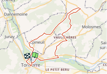
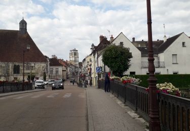
Randonnée A pied de 18,2 km à découvrir à Bourgogne-Franche-Comté, Yonne, Tonnerre. Cette randonnée est proposée par SityTrail - itinéraires balisés pédestres.
Description
Randonnée créée par Syndicat Mixte du Pays du Tonnerrois.
Symbole: yellow
Localisation
Pays :
France
Région :
Bourgogne-Franche-Comté
Département/Province :
Yonne
Commune :
Tonnerre
Localité :
Unknown
Départ:(Dec)
Départ:(UTM)
572844 ; 5301087 (31T) N.
Commentaires
Randonnées à proximité
![Randonnée Marche Tonnerre - Tonnerre 231105 - Photo](https://media.geolcdn.com/t/375/260/b9ea4c20-f501-4759-a2fa-37910a428005.jpg&format=jpg&maxdim=2)
![Marche Marche](https://static1.geolcdn.com/sitytour/trail-icons/101.png)
Tonnerre 231105
Marche
Moyen
Tonnerre,
Bourgogne-Franche-Comté,
Yonne,
France
![](/images/other/stat-length.png)
5,2 km | 6,1 km-effort
2h 31min
![](https://static1.geolcdn.com/siteimages/upload/files/16400158638029165_repeat_loop_refresh_sync_direction_icon.png)
Oui
![Randonnée A pied Tonnerre - Forêt de Tonnerre - Photo](https://media.geolcdn.com/t/375/260/59689acc-2fa4-42a6-ad0e-287854514290.jpeg&format=jpg&maxdim=2)
![A pied A pied](https://static1.geolcdn.com/sitytour/trail-icons/100.png)
Forêt de Tonnerre
A pied
Moyen
Tonnerre,
Bourgogne-Franche-Comté,
Yonne,
France
![](/images/other/stat-length.png)
19,9 km | 24 km-effort
5h 23min
![](https://static1.geolcdn.com/siteimages/upload/files/16400158638029165_repeat_loop_refresh_sync_direction_icon.png)
Oui
![Randonnée Cyclotourisme Tonnerre - 71 Bourgogne J6/8 - Photo](https://media.geolcdn.com/t/375/260/38eac58b-7aeb-4db7-b443-c99c502d749f.jpg&format=jpg&maxdim=2)
![Cyclotourisme Cyclotourisme](https://static1.geolcdn.com/sitytour/trail-icons/204.png)
71 Bourgogne J6/8
Cyclotourisme
Moyen
Tonnerre,
Bourgogne-Franche-Comté,
Yonne,
France
![](/images/other/stat-length.png)
91 km | 99 km-effort
10h 3min
![](https://static1.geolcdn.com/siteimages/upload/files/16400158638029165_repeat_loop_refresh_sync_direction_icon.png)
Non
![Randonnée Vélo électrique Tonnerre - Canal de Bourgogne_Etape 2 - Photo](https://media.geolcdn.com/t/375/260/ext.jpg?maxdim=2&url=https%3A%2F%2Fstatic1.geolcdn.com%2Fsiteimages%2Fupload%2Ffiles%2F1524743154velo.jpg)
![Vélo électrique Vélo électrique](https://static1.geolcdn.com/sitytour/trail-icons/205.png)
Canal de Bourgogne_Etape 2
Vélo électrique
Très facile
Tonnerre,
Bourgogne-Franche-Comté,
Yonne,
France
![](/images/other/stat-length.png)
31 km | 33 km-effort
Inconnu
![](https://static1.geolcdn.com/siteimages/upload/files/16400158638029165_repeat_loop_refresh_sync_direction_icon.png)
Non
![Randonnée V.T.C. Tonnerre - Tonnerre - Monnard - Photo](https://media.geolcdn.com/t/375/260/ext.jpg?maxdim=2&url=https%3A%2F%2Fstatic1.geolcdn.com%2Fsiteimages%2Fupload%2Ffiles%2F1524743154velo.jpg)
![V.T.C. V.T.C.](https://static1.geolcdn.com/sitytour/trail-icons/203.png)
Tonnerre - Monnard
V.T.C.
Très facile
Tonnerre,
Bourgogne-Franche-Comté,
Yonne,
France
![](/images/other/stat-length.png)
58 km | 63 km-effort
6h 43min
![](https://static1.geolcdn.com/siteimages/upload/files/16400158638029165_repeat_loop_refresh_sync_direction_icon.png)
Non
![Randonnée Marche Vézinnes - baladevoi romaine - Photo](https://media.geolcdn.com/t/375/260/ext.jpg?maxdim=2&url=https%3A%2F%2Fstatic1.geolcdn.com%2Fsiteimages%2Fupload%2Ffiles%2F1553511878bg_sport_marche.png)
![Marche Marche](https://static1.geolcdn.com/sitytour/trail-icons/101.png)
baladevoi romaine
Marche
Moyen
Vézinnes,
Bourgogne-Franche-Comté,
Yonne,
France
![](/images/other/stat-length.png)
8,2 km | 10,4 km-effort
2h 33min
![](https://static1.geolcdn.com/siteimages/upload/files/16400158638029165_repeat_loop_refresh_sync_direction_icon.png)
Non
![Randonnée Cyclotourisme Tonnerre - Tonnerre / pouilly en Auxois - Photo](https://media.geolcdn.com/t/375/260/ext.jpg?maxdim=2&url=https%3A%2F%2Fstatic1.geolcdn.com%2Fsiteimages%2Fupload%2Ffiles%2F1524743154velo.jpg)
![Cyclotourisme Cyclotourisme](https://static1.geolcdn.com/sitytour/trail-icons/204.png)
Tonnerre / pouilly en Auxois
Cyclotourisme
Très difficile
Tonnerre,
Bourgogne-Franche-Comté,
Yonne,
France
![](/images/other/stat-length.png)
108 km | 125 km-effort
5h 29min
![](https://static1.geolcdn.com/siteimages/upload/files/16400158638029165_repeat_loop_refresh_sync_direction_icon.png)
Non
![Randonnée Cyclotourisme Tonnerre - TB 13 Epineuil - Ancy le Franc - Photo](https://media.geolcdn.com/t/375/260/ext.jpg?maxdim=2&url=https%3A%2F%2Fstatic1.geolcdn.com%2Fsiteimages%2Fupload%2Ffiles%2F1524743154velo.jpg)
![Cyclotourisme Cyclotourisme](https://static1.geolcdn.com/sitytour/trail-icons/204.png)
TB 13 Epineuil - Ancy le Franc
Cyclotourisme
Difficile
Tonnerre,
Bourgogne-Franche-Comté,
Yonne,
France
![](/images/other/stat-length.png)
30 km | 33 km-effort
2h 33min
![](https://static1.geolcdn.com/siteimages/upload/files/16400158638029165_repeat_loop_refresh_sync_direction_icon.png)
Non
![Randonnée Course à pied Tonnerre - Jogging sur Tonnerre - Photo](https://media.geolcdn.com/t/375/260/ext.jpg?maxdim=2&url=https%3A%2F%2Fstatic1.geolcdn.com%2Fsiteimages%2Fupload%2Ffiles%2F1524743154running.jpg)
![Course à pied Course à pied](https://static1.geolcdn.com/sitytour/trail-icons/103.png)
Jogging sur Tonnerre
Course à pied
Très facile
Tonnerre,
Bourgogne-Franche-Comté,
Yonne,
France
![](/images/other/stat-length.png)
7,6 km | 8,2 km-effort
58min
![](https://static1.geolcdn.com/siteimages/upload/files/16400158638029165_repeat_loop_refresh_sync_direction_icon.png)
Oui