![](/images/other/stat-length.png)
![Randonnée A pied Arquata del Tronto - (SI N02) Colle d'Arquata - Madonna delle Coste - Photo](https://media.geolcdn.com/t/1900/400/58f526c0-9d7b-4c12-b64a-df9c95b52a6e.jpeg&format=pjpeg&maxdim=2)
(SI N02) Colle d'Arquata - Madonna delle Coste
SityTrail - itinéraires balisés pédestres
Tous les sentiers balisés d’Europe GUIDE+
![Longueur](/images/other/stat-length.png)
Longueur
13,3 km
![Altitude max](https://static1.geolcdn.com/siteimages/upload/files/1508320355ic_sort_altitude_max_24dp.png)
Altitude max
1137 m
![Dénivelé positif](https://static1.geolcdn.com/siteimages/upload/files/1508320355ic_sort_den_pos_24dp.png)
Dénivelé positif
608 m
![Km-Effort](/images/other/stat-length.png)
Km-Effort
21 km
![Altitude min](https://static1.geolcdn.com/siteimages/upload/files/1508320355ic_sort_altitude_min_24dp.png)
Altitude min
682 m
![Dénivelé négatif](https://static1.geolcdn.com/siteimages/upload/files/1508320355ic_sort_den_neg_24dp.png)
Dénivelé négatif
561 m
![Boucle](https://static1.geolcdn.com/siteimages/upload/files/16400158638029165_repeat_loop_refresh_sync_direction_icon.png)
Boucle
Non
Balise
Date de création :
2022-02-15 13:56:39.936
Dernière modification :
2022-03-01 13:32:14.051
![A pied](https://static1.geolcdn.com/sitytour/trail-icons/100.png)
4h49
Difficulté : Moyen
![Scannez ce code QR pour ouvrir la randonnée dans l'application SityTrail](https://capi.geolives.com/qq0zvz2zws4bq2lad0pu/sitytour/trails/3119642/qr.png?size=200)
Application GPS de randonnée GRATUITE
À propos
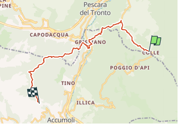
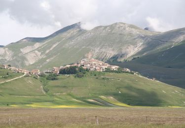
Randonnée A pied de 13,3 km à découvrir à Marches, Ascoli Piceno, Arquata del Tronto. Cette randonnée est proposée par SityTrail - itinéraires balisés pédestres.
Description
Sentiero Italia CAI 2019
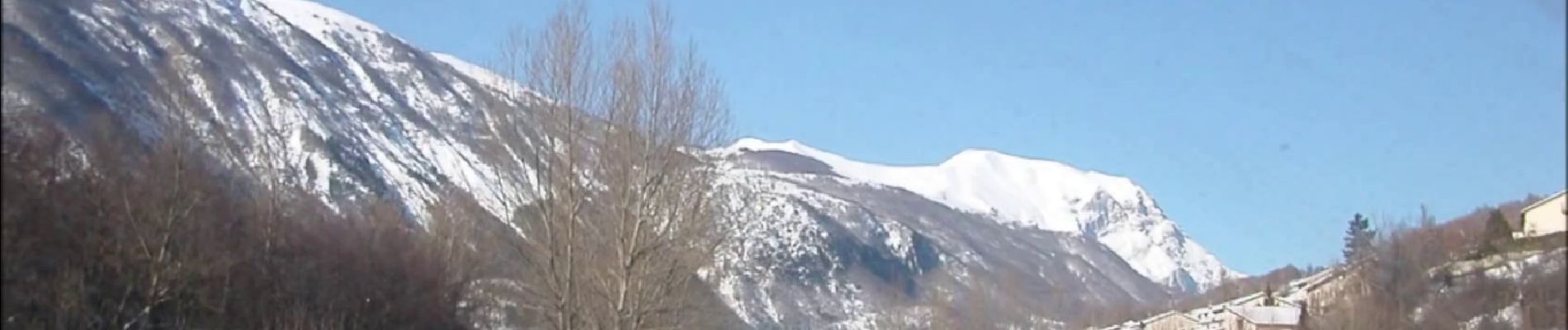
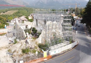
Localisation
Pays :
Italie
Région :
Marches
Département/Province :
Ascoli Piceno
Commune :
Arquata del Tronto
Localité :
Unknown
Départ:(Dec)
Départ:(UTM)
361551 ; 4732093 (33T) N.
Commentaires
Randonnées à proximité
![Randonnée A pied Campotosto - (SI P14) Campotosto - Amatrice - Photo](https://media.geolcdn.com/t/375/260/a8557ca1-562a-4cc2-9728-cf5c11b2c754.jpeg&format=jpg&maxdim=2)
![A pied A pied](https://static1.geolcdn.com/sitytour/trail-icons/100.png)
(SI P14) Campotosto - Amatrice
A pied
Facile
Campotosto,
Abruzzes,
L'Aquila,
Italie
![](/images/other/stat-length.png)
14,1 km | 19,8 km-effort
4h 30min
![](https://static1.geolcdn.com/siteimages/upload/files/16400158638029165_repeat_loop_refresh_sync_direction_icon.png)
Non
![Randonnée A pied Arquata del Tronto - Forca di Presta/Monte Vettore - Photo](https://media.geolcdn.com/t/375/260/8687556c-04c1-4df4-ad9d-8399c1aadd0f.jpeg&format=jpg&maxdim=2)
![A pied A pied](https://static1.geolcdn.com/sitytour/trail-icons/100.png)
Forca di Presta/Monte Vettore
A pied
Facile
Arquata del Tronto,
Marches,
Ascoli Piceno,
Italie
![](/images/other/stat-length.png)
5 km | 14,1 km-effort
3h 12min
![](https://static1.geolcdn.com/siteimages/upload/files/16400158638029165_repeat_loop_refresh_sync_direction_icon.png)
Non
![Randonnée A pied Amatrice - (SI O20) Amatrice - Accumoli - Photo](https://media.geolcdn.com/t/375/260/5d757b40-861d-408c-9d82-f7814df436d9.jpeg&format=jpg&maxdim=2)
![A pied A pied](https://static1.geolcdn.com/sitytour/trail-icons/100.png)
(SI O20) Amatrice - Accumoli
A pied
Moyen
Amatrice,
Latium,
Rieti,
Italie
![](/images/other/stat-length.png)
15,1 km | 24 km-effort
5h 29min
![](https://static1.geolcdn.com/siteimages/upload/files/16400158638029165_repeat_loop_refresh_sync_direction_icon.png)
Non
![Randonnée A pied Amatrice - (SI O19) Torrita - Amatrice - Photo](https://media.geolcdn.com/t/375/260/5d757b40-861d-408c-9d82-f7814df436d9.jpeg&format=jpg&maxdim=2)
![A pied A pied](https://static1.geolcdn.com/sitytour/trail-icons/100.png)
(SI O19) Torrita - Amatrice
A pied
Facile
Amatrice,
Latium,
Rieti,
Italie
![](/images/other/stat-length.png)
9,1 km | 12,5 km-effort
2h 50min
![](https://static1.geolcdn.com/siteimages/upload/files/16400158638029165_repeat_loop_refresh_sync_direction_icon.png)
Non
![Randonnée A pied Acquasanta Terme - (SI N01) San Martino - Colle d'Arquata - Photo](https://media.geolcdn.com/t/375/260/359ba037-e302-4893-b6e1-32e7a8cb7052.jpeg&format=jpg&maxdim=2)
![A pied A pied](https://static1.geolcdn.com/sitytour/trail-icons/100.png)
(SI N01) San Martino - Colle d'Arquata
A pied
Difficile
Acquasanta Terme,
Marches,
Ascoli Piceno,
Italie
![](/images/other/stat-length.png)
21 km | 38 km-effort
8h 32min
![](https://static1.geolcdn.com/siteimages/upload/files/16400158638029165_repeat_loop_refresh_sync_direction_icon.png)
Non
![Randonnée A pied Rocca Santa Maria - (SI P17N) Ceppo - San Martino - Photo](https://media.geolcdn.com/t/375/260/359ba037-e302-4893-b6e1-32e7a8cb7052.jpeg&format=jpg&maxdim=2)
![A pied A pied](https://static1.geolcdn.com/sitytour/trail-icons/100.png)
(SI P17N) Ceppo - San Martino
A pied
Facile
Rocca Santa Maria,
Abruzzes,
Teramo,
Italie
![](/images/other/stat-length.png)
10,5 km | 16,2 km-effort
3h 40min
![](https://static1.geolcdn.com/siteimages/upload/files/16400158638029165_repeat_loop_refresh_sync_direction_icon.png)
Non
![Randonnée A pied Campotosto - (SI P14N) Campotosto - Cesacastina - Photo](https://media.geolcdn.com/t/375/260/236dd719-8d1b-4f85-bc50-5c02dd17bffd.jpeg&format=jpg&maxdim=2)
![A pied A pied](https://static1.geolcdn.com/sitytour/trail-icons/100.png)
(SI P14N) Campotosto - Cesacastina
A pied
Moyen
Campotosto,
Abruzzes,
L'Aquila,
Italie
![](/images/other/stat-length.png)
10,9 km | 20 km-effort
4h 32min
![](https://static1.geolcdn.com/siteimages/upload/files/16400158638029165_repeat_loop_refresh_sync_direction_icon.png)
Non
![Randonnée A pied Ascoli Piceno - CTP S.s Cosma e Damiano - Photo](https://media.geolcdn.com/t/375/260/caa4ed67-f517-46a2-b3ce-67d32f2bf2f3.jpeg&format=jpg&maxdim=2)
![A pied A pied](https://static1.geolcdn.com/sitytour/trail-icons/100.png)
CTP S.s Cosma e Damiano
A pied
Facile
Ascoli Piceno,
Marches,
Ascoli Piceno,
Italie
![](/images/other/stat-length.png)
9,9 km | 15,6 km-effort
3h 32min
![](https://static1.geolcdn.com/siteimages/upload/files/16400158638029165_repeat_loop_refresh_sync_direction_icon.png)
Non
![Randonnée A pied Norcia - Castelluccio di Norcia (SI)/Rifugio Capanna Ghezzi - Photo](https://media.geolcdn.com/t/375/260/f230901a-24a0-4d3d-a1bf-0d8f6baa121b.jpeg&format=jpg&maxdim=2)
![A pied A pied](https://static1.geolcdn.com/sitytour/trail-icons/100.png)
Castelluccio di Norcia (SI)/Rifugio Capanna Ghezzi
A pied
Facile
Norcia,
Ombrie,
Perugia,
Italie
![](/images/other/stat-length.png)
5,3 km | 8,2 km-effort
1h 52min
![](https://static1.geolcdn.com/siteimages/upload/files/16400158638029165_repeat_loop_refresh_sync_direction_icon.png)
Non