![](/images/other/stat-length.png)
![Randonnée A pied Pieve Santo Stefano - Via di Francesco - Tappa 2 Pieve Santo Stefano-Pian della Capanna - Photo](https://media.geolcdn.com/t/1900/400/ec00659c-16a0-4999-87c1-8f9933b24f06.jpeg&format=pjpeg&maxdim=2)
Via di Francesco - Tappa 2 Pieve Santo Stefano-Pian della Capanna
SityTrail - itinéraires balisés pédestres
Tous les sentiers balisés d’Europe GUIDE+
![Longueur](/images/other/stat-length.png)
![Altitude max](https://static1.geolcdn.com/siteimages/upload/files/1508320355ic_sort_altitude_max_24dp.png)
![Dénivelé positif](https://static1.geolcdn.com/siteimages/upload/files/1508320355ic_sort_den_pos_24dp.png)
![Km-Effort](/images/other/stat-length.png)
![Altitude min](https://static1.geolcdn.com/siteimages/upload/files/1508320355ic_sort_altitude_min_24dp.png)
![Dénivelé négatif](https://static1.geolcdn.com/siteimages/upload/files/1508320355ic_sort_den_neg_24dp.png)
![Boucle](https://static1.geolcdn.com/siteimages/upload/files/16400158638029165_repeat_loop_refresh_sync_direction_icon.png)
![A pied](https://static1.geolcdn.com/sitytour/trail-icons/100.png)
6h04
Difficulté : Moyen
![Scannez ce code QR pour ouvrir la randonnée dans l'application SityTrail](https://capi.geolives.com/qq0zvz2zws4bq2lad0pu/sitytour/trails/3119395/qr.png?size=200)
Application GPS de randonnée GRATUITE
À propos
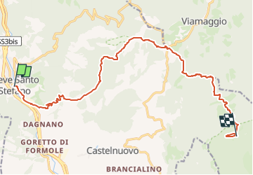
Randonnée A pied de 16,6 km à découvrir à Toscane, Arezzo, Pieve Santo Stefano. Cette randonnée est proposée par SityTrail - itinéraires balisés pédestres.
Description
È un unico cammino per raggiungere Assisi sui passi di San Francesco, partendo da Nord (La Verna) o da Sud (Roma)
. È un itinerario che collega tra loro alcuni luoghi che testimoniano della vita e della predicazione del Santo di Assisi; un cammino di pellegrinaggio, che intende riproporre l'esperienza francescana nelle terre che il Poverello ha calcato nelle sue itineranze.
Site web: https://www.viadifrancesco.it/
Localisation
Commentaires
Randonnées à proximité
![Randonnée A pied Caprese Michelangelo - (SI L03S) Caprese Michelangelo - Chiusi della Verna - Photo](https://media.geolcdn.com/t/375/260/345240c6-a250-47ef-8cb5-c2535653ba6b.jpeg&format=jpg&maxdim=2)
![A pied A pied](https://static1.geolcdn.com/sitytour/trail-icons/100.png)
A pied
![](/images/other/stat-length.png)
![](https://static1.geolcdn.com/siteimages/upload/files/16400158638029165_repeat_loop_refresh_sync_direction_icon.png)
![Randonnée A pied Pieve Santo Stefano - Cammino di San Francesco da Rimini a La Verna: Tappa 5B - Photo](https://media.geolcdn.com/t/375/260/1afb4231-c1e3-4968-ac99-f6dfc734db41.jpeg&format=jpg&maxdim=2)
![A pied A pied](https://static1.geolcdn.com/sitytour/trail-icons/100.png)
A pied
![](/images/other/stat-length.png)
![](https://static1.geolcdn.com/siteimages/upload/files/16400158638029165_repeat_loop_refresh_sync_direction_icon.png)
![Randonnée A pied Pieve Santo Stefano - IT-78 - Photo](https://media.geolcdn.com/t/375/260/4ef3c57e-61c2-4f83-b61c-a14bd30aa786.jpeg&format=jpg&maxdim=2)
![A pied A pied](https://static1.geolcdn.com/sitytour/trail-icons/100.png)
A pied
![](/images/other/stat-length.png)
![](https://static1.geolcdn.com/siteimages/upload/files/16400158638029165_repeat_loop_refresh_sync_direction_icon.png)
![Randonnée A pied Pieve Santo Stefano - IT-2-GEA - Photo](https://media.geolcdn.com/t/375/260/ec00659c-16a0-4999-87c1-8f9933b24f06.jpeg&format=jpg&maxdim=2)
![A pied A pied](https://static1.geolcdn.com/sitytour/trail-icons/100.png)
A pied
![](/images/other/stat-length.png)
![](https://static1.geolcdn.com/siteimages/upload/files/16400158638029165_repeat_loop_refresh_sync_direction_icon.png)
![Randonnée A pied Pieve Santo Stefano - IT-66 - Photo](https://media.geolcdn.com/t/375/260/ext.jpg?maxdim=2&url=https%3A%2F%2Fstatic1.geolcdn.com%2Fsiteimages%2Fupload%2Ffiles%2F1545311037marcheuse_200dpi.jpg)
![A pied A pied](https://static1.geolcdn.com/sitytour/trail-icons/100.png)
A pied
![](/images/other/stat-length.png)
![](https://static1.geolcdn.com/siteimages/upload/files/16400158638029165_repeat_loop_refresh_sync_direction_icon.png)
![Randonnée A pied Pieve Santo Stefano - IT-12 - Photo](https://media.geolcdn.com/t/375/260/ext.jpg?maxdim=2&url=https%3A%2F%2Fstatic1.geolcdn.com%2Fsiteimages%2Fupload%2Ffiles%2F1545311037marcheuse_200dpi.jpg)
![A pied A pied](https://static1.geolcdn.com/sitytour/trail-icons/100.png)
A pied
![](/images/other/stat-length.png)
![](https://static1.geolcdn.com/siteimages/upload/files/16400158638029165_repeat_loop_refresh_sync_direction_icon.png)
![Randonnée Marche Pieve Santo Stefano - Pieve Santo Stefano - Sansepolcro - Photo](https://media.geolcdn.com/t/375/260/ext.jpg?maxdim=2&url=https%3A%2F%2Fstatic1.geolcdn.com%2Fsiteimages%2Fupload%2Ffiles%2F1553511878bg_sport_marche.png)
![Marche Marche](https://static1.geolcdn.com/sitytour/trail-icons/101.png)
Marche
![](/images/other/stat-length.png)
![](https://static1.geolcdn.com/siteimages/upload/files/16400158638029165_repeat_loop_refresh_sync_direction_icon.png)