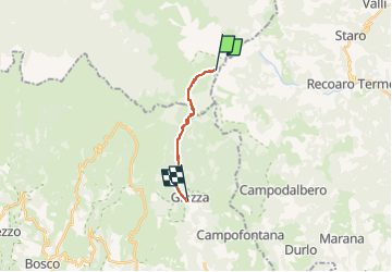
![](/images/other/stat-length.png)
![Randonnée A pied Ala - Giazza, Dogana Vecchia, Rifugio Pompeo Scalorbi - Photo](https://media.geolcdn.com/t/1900/400/83a31790-dc1e-4af9-b4ba-530f507478c5.jpeg&format=pjpeg&maxdim=2)
Giazza, Dogana Vecchia, Rifugio Pompeo Scalorbi
SityTrail - itinéraires balisés pédestres
Tous les sentiers balisés d’Europe GUIDE+
![Longueur](/images/other/stat-length.png)
![Altitude max](https://static1.geolcdn.com/siteimages/upload/files/1508320355ic_sort_altitude_max_24dp.png)
![Dénivelé positif](https://static1.geolcdn.com/siteimages/upload/files/1508320355ic_sort_den_pos_24dp.png)
![Km-Effort](/images/other/stat-length.png)
![Altitude min](https://static1.geolcdn.com/siteimages/upload/files/1508320355ic_sort_altitude_min_24dp.png)
![Dénivelé négatif](https://static1.geolcdn.com/siteimages/upload/files/1508320355ic_sort_den_neg_24dp.png)
![Boucle](https://static1.geolcdn.com/siteimages/upload/files/16400158638029165_repeat_loop_refresh_sync_direction_icon.png)
![A pied](https://static1.geolcdn.com/sitytour/trail-icons/100.png)
3h01
Difficulté : Facile
![Scannez ce code QR pour ouvrir la randonnée dans l'application SityTrail](https://capi.geolives.com/qq0zvz2zws4bq2lad0pu/sitytour/trails/3117941/qr.png?size=200)
Application GPS de randonnée GRATUITE
À propos
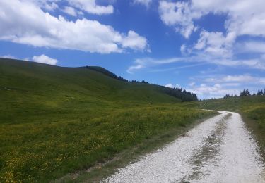
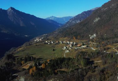
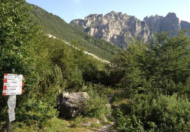
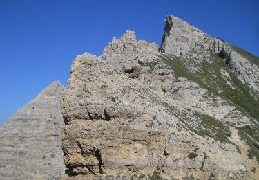
Randonnée A pied de 9,3 km à découvrir à Trentin-Haut-Adige, Provincia di Trento, Ala. Cette randonnée est proposée par SityTrail - itinéraires balisés pédestres.
Description
Randonnée créée par Club Alpino Italiano Sezione di Tregnago.
Relation mantained by Club Alpino Italiano Sezione di Tregnago, before making changes contact the CAI structure
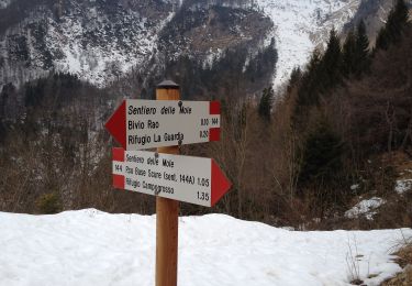
Symbole: 185 on white red flag
Localisation
Commentaires
Randonnées à proximité
![Randonnée A pied Recoaro Terme - Sentiero delle Mole - Photo](https://media.geolcdn.com/t/375/260/415f08fe-adfd-4017-b0e4-f8688286a2bc.jpeg&format=jpg&maxdim=2)
![A pied A pied](https://static1.geolcdn.com/sitytour/trail-icons/100.png)
A pied
![](/images/other/stat-length.png)
![](https://static1.geolcdn.com/siteimages/upload/files/16400158638029165_repeat_loop_refresh_sync_direction_icon.png)
![Randonnée A pied Bosco Chiesanuova - IT-110 - Photo](https://media.geolcdn.com/t/375/260/1b887ebe-f6b7-4c16-9927-42dff44bac08.jpeg&format=jpg&maxdim=2)
![A pied A pied](https://static1.geolcdn.com/sitytour/trail-icons/100.png)
A pied
![](/images/other/stat-length.png)
![](https://static1.geolcdn.com/siteimages/upload/files/16400158638029165_repeat_loop_refresh_sync_direction_icon.png)
![Randonnée A pied Bosco Chiesanuova - Pissarotta ponte SP 15 - San Giorgio - Photo](https://media.geolcdn.com/t/375/260/ef01f4c8-3e9b-4e33-af57-6e5037d69b69.jpeg&format=jpg&maxdim=2)
![A pied A pied](https://static1.geolcdn.com/sitytour/trail-icons/100.png)
A pied
![](/images/other/stat-length.png)
![](https://static1.geolcdn.com/siteimages/upload/files/16400158638029165_repeat_loop_refresh_sync_direction_icon.png)
![Randonnée A pied Recoaro Terme - Sentiero C.A.I. 151 - Photo](https://media.geolcdn.com/t/375/260/18013885-4348-49a4-81fe-edfd1d618f37.jpeg&format=jpg&maxdim=2)
![A pied A pied](https://static1.geolcdn.com/sitytour/trail-icons/100.png)
A pied
![](/images/other/stat-length.png)
![](https://static1.geolcdn.com/siteimages/upload/files/16400158638029165_repeat_loop_refresh_sync_direction_icon.png)
![Randonnée A pied Recoaro Terme - 120, dei Grandi Alberi - Photo](https://media.geolcdn.com/t/375/260/9588f16c-c917-4424-b013-714c045a31a5.jpeg&format=jpg&maxdim=2)
![A pied A pied](https://static1.geolcdn.com/sitytour/trail-icons/100.png)
A pied
![](/images/other/stat-length.png)
![](https://static1.geolcdn.com/siteimages/upload/files/16400158638029165_repeat_loop_refresh_sync_direction_icon.png)
![Randonnée A pied Ala - IT-109 - Photo](https://media.geolcdn.com/t/375/260/7f6733d7-2716-4f63-8aa5-a1aee0497bac.jpeg&format=jpg&maxdim=2)
![A pied A pied](https://static1.geolcdn.com/sitytour/trail-icons/100.png)
A pied
![](/images/other/stat-length.png)
![](https://static1.geolcdn.com/siteimages/upload/files/16400158638029165_repeat_loop_refresh_sync_direction_icon.png)
![Randonnée A pied Ala - IT-108 - Photo](https://media.geolcdn.com/t/375/260/162d9af4-f420-48ab-a680-8ee8a91aa019.jpeg&format=jpg&maxdim=2)
![A pied A pied](https://static1.geolcdn.com/sitytour/trail-icons/100.png)
A pied
![](/images/other/stat-length.png)
![](https://static1.geolcdn.com/siteimages/upload/files/16400158638029165_repeat_loop_refresh_sync_direction_icon.png)
![Randonnée A pied Recoaro Terme - Sentiero di arroccamento del Sengio Alto - Photo](https://media.geolcdn.com/t/375/260/415f08fe-adfd-4017-b0e4-f8688286a2bc.jpeg&format=jpg&maxdim=2)
![A pied A pied](https://static1.geolcdn.com/sitytour/trail-icons/100.png)
A pied
![](/images/other/stat-length.png)
![](https://static1.geolcdn.com/siteimages/upload/files/16400158638029165_repeat_loop_refresh_sync_direction_icon.png)
![Randonnée A pied Ala - Sentiero Boale dei Fondi - Photo](https://media.geolcdn.com/t/375/260/162d9af4-f420-48ab-a680-8ee8a91aa019.jpeg&format=jpg&maxdim=2)
![A pied A pied](https://static1.geolcdn.com/sitytour/trail-icons/100.png)
A pied
![](/images/other/stat-length.png)
![](https://static1.geolcdn.com/siteimages/upload/files/16400158638029165_repeat_loop_refresh_sync_direction_icon.png)