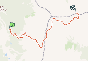
![](/images/other/stat-length.png)
![Randonnée A pied Deutschnofen - Nova Ponente - Dolomiti 18 - Photo](https://media.geolcdn.com/t/1900/400/58f81fca-3213-453f-a23a-94a99a4e2d1d.jpeg&format=pjpeg&maxdim=2)
Dolomiti 18
SityTrail - itinéraires balisés pédestres
Tous les sentiers balisés d’Europe GUIDE+
![Longueur](/images/other/stat-length.png)
![Altitude max](https://static1.geolcdn.com/siteimages/upload/files/1508320355ic_sort_altitude_max_24dp.png)
![Dénivelé positif](https://static1.geolcdn.com/siteimages/upload/files/1508320355ic_sort_den_pos_24dp.png)
![Km-Effort](/images/other/stat-length.png)
![Altitude min](https://static1.geolcdn.com/siteimages/upload/files/1508320355ic_sort_altitude_min_24dp.png)
![Dénivelé négatif](https://static1.geolcdn.com/siteimages/upload/files/1508320355ic_sort_den_neg_24dp.png)
![Boucle](https://static1.geolcdn.com/siteimages/upload/files/16400158638029165_repeat_loop_refresh_sync_direction_icon.png)
![A pied](https://static1.geolcdn.com/sitytour/trail-icons/100.png)
4h19
Difficulté : Facile
![Scannez ce code QR pour ouvrir la randonnée dans l'application SityTrail](https://capi.geolives.com/qq0zvz2zws4bq2lad0pu/sitytour/trails/3117594/qr.png?size=200)
Application GPS de randonnée GRATUITE
À propos
Randonnée A pied de 7,5 km à découvrir à Trentin-Haut-Adige, Haut-Adige, Deutschnofen - Nova Ponente. Cette randonnée est proposée par SityTrail - itinéraires balisés pédestres.
Description
Randonnée créée par AVS Alpenverein Südtirol.
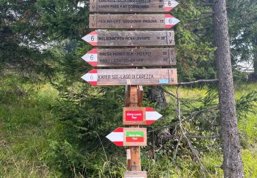
Markierung aus Symbolbeschreibung abgeleitet
Symbole: Weißer Balken auf rotem Grund. Nr.18 in schwarzer Schrift
Localisation
Commentaires
Randonnées à proximité
![Randonnée A pied Ville di Fiemme - (SI C14N) Passo Lavaze - Obereggen - Photo](https://media.geolcdn.com/t/375/260/b2fa3ea8-941c-4df4-804d-fbf84e9ebdb3.jpeg&format=jpg&maxdim=2)
![A pied A pied](https://static1.geolcdn.com/sitytour/trail-icons/100.png)
A pied
![](/images/other/stat-length.png)
![](https://static1.geolcdn.com/siteimages/upload/files/16400158638029165_repeat_loop_refresh_sync_direction_icon.png)
![Randonnée A pied Deutschnofen - Nova Ponente - (SI C15N) Obereggen - Bivio Rifugio Coronelle - Photo](https://media.geolcdn.com/t/375/260/311835f6-16c6-46bc-b1d4-99f681c5d7a9.jpeg&format=jpg&maxdim=2)
![A pied A pied](https://static1.geolcdn.com/sitytour/trail-icons/100.png)
A pied
![](/images/other/stat-length.png)
![](https://static1.geolcdn.com/siteimages/upload/files/16400158638029165_repeat_loop_refresh_sync_direction_icon.png)
![Randonnée A pied Predazzo - IT-E515 - Photo](https://media.geolcdn.com/t/375/260/010a5566-23e8-4008-81f2-4f4f7a8fdb71.jpeg&format=jpg&maxdim=2)
![A pied A pied](https://static1.geolcdn.com/sitytour/trail-icons/100.png)
A pied
![](/images/other/stat-length.png)
![](https://static1.geolcdn.com/siteimages/upload/files/16400158638029165_repeat_loop_refresh_sync_direction_icon.png)
![Randonnée A pied Tesero - IT-E574 - Photo](https://media.geolcdn.com/t/375/260/b3842d45-ffdf-4574-98c4-7bc37d5af8fb.jpeg&format=jpg&maxdim=2)
![A pied A pied](https://static1.geolcdn.com/sitytour/trail-icons/100.png)
A pied
![](/images/other/stat-length.png)
![](https://static1.geolcdn.com/siteimages/upload/files/16400158638029165_repeat_loop_refresh_sync_direction_icon.png)
![Randonnée A pied Deutschnofen - Nova Ponente - IT-E504 - Photo](https://media.geolcdn.com/t/375/260/8a4281af-96b3-414c-b0ad-520a15a87cab.jpeg&format=jpg&maxdim=2)
![A pied A pied](https://static1.geolcdn.com/sitytour/trail-icons/100.png)
A pied
![](/images/other/stat-length.png)
![](https://static1.geolcdn.com/siteimages/upload/files/16400158638029165_repeat_loop_refresh_sync_direction_icon.png)
![Randonnée A pied Deutschnofen - Nova Ponente - Dolomiti 9 - Photo](https://media.geolcdn.com/t/375/260/42e90720-2dc2-4890-9e99-75eeec71e67d.jpeg&format=jpg&maxdim=2)
![A pied A pied](https://static1.geolcdn.com/sitytour/trail-icons/100.png)
A pied
![](/images/other/stat-length.png)
![](https://static1.geolcdn.com/siteimages/upload/files/16400158638029165_repeat_loop_refresh_sync_direction_icon.png)
![Randonnée A pied Deutschnofen - Nova Ponente - Dolomiti 22 - Photo](https://media.geolcdn.com/t/375/260/0d9d068f-4eb5-48b0-aca7-81e8dd4de875.jpeg&format=jpg&maxdim=2)
![A pied A pied](https://static1.geolcdn.com/sitytour/trail-icons/100.png)
A pied
![](/images/other/stat-length.png)
![](https://static1.geolcdn.com/siteimages/upload/files/16400158638029165_repeat_loop_refresh_sync_direction_icon.png)
![Randonnée A pied Predazzo - IT-E515B - Photo](https://media.geolcdn.com/t/375/260/ext.jpg?maxdim=2&url=https%3A%2F%2Fstatic1.geolcdn.com%2Fsiteimages%2Fupload%2Ffiles%2F1545311037marcheuse_200dpi.jpg)
![A pied A pied](https://static1.geolcdn.com/sitytour/trail-icons/100.png)
A pied
![](/images/other/stat-length.png)
![](https://static1.geolcdn.com/siteimages/upload/files/16400158638029165_repeat_loop_refresh_sync_direction_icon.png)
![Randonnée Marche Welschnofen - Nova Levante - Lago di carezza - Photo](https://media.geolcdn.com/t/375/260/366d5606-be7c-4a54-8c22-a358ba0d32b8.jpg&format=jpg&maxdim=2)
![Marche Marche](https://static1.geolcdn.com/sitytour/trail-icons/101.png)
Marche
![](/images/other/stat-length.png)
![](https://static1.geolcdn.com/siteimages/upload/files/16400158638029165_repeat_loop_refresh_sync_direction_icon.png)