![](/images/other/stat-length.png)
![Randonnée A pied Cossogno - P02 - Cossogno - Pizzo Pernice - Photo](https://media.geolcdn.com/t/1900/400/bd63e80d-7115-4bf5-9872-9fb56f21b042.jpeg&format=pjpeg&maxdim=2)
P02 - Cossogno - Pizzo Pernice
SityTrail - itinéraires balisés pédestres
Tous les sentiers balisés d’Europe GUIDE+
![Longueur](/images/other/stat-length.png)
![Altitude max](https://static1.geolcdn.com/siteimages/upload/files/1508320355ic_sort_altitude_max_24dp.png)
![Dénivelé positif](https://static1.geolcdn.com/siteimages/upload/files/1508320355ic_sort_den_pos_24dp.png)
![Km-Effort](/images/other/stat-length.png)
![Altitude min](https://static1.geolcdn.com/siteimages/upload/files/1508320355ic_sort_altitude_min_24dp.png)
![Dénivelé négatif](https://static1.geolcdn.com/siteimages/upload/files/1508320355ic_sort_den_neg_24dp.png)
![Boucle](https://static1.geolcdn.com/siteimages/upload/files/16400158638029165_repeat_loop_refresh_sync_direction_icon.png)
![A pied](https://static1.geolcdn.com/sitytour/trail-icons/100.png)
3h55
Difficulté : Facile
![Scannez ce code QR pour ouvrir la randonnée dans l'application SityTrail](https://capi.geolives.com/qq0zvz2zws4bq2lad0pu/sitytour/trails/3116486/qr.png?size=200)
Application GPS de randonnée GRATUITE
À propos
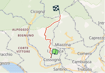
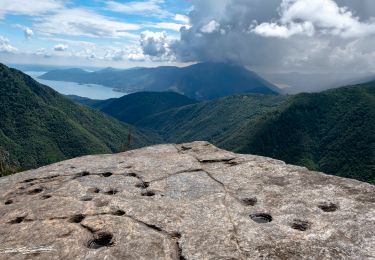
Randonnée A pied de 6,1 km à découvrir à Piémont, Verbano-Cusio-Ossola, Cossogno. Cette randonnée est proposée par SityTrail - itinéraires balisés pédestres.
Description
Relation with photos (click on → Web site) mantained by Danilo (CAI Pallanza)
Symbole: unmarked
Site web: http://www.estmonterosa.it/catasto-percorsi-vco-val-grande-settore-p.html
Localisation
Commentaires
Randonnées à proximité
![Randonnée A pied Mergozzo - A58 - Mergozzo - Linea Cadorna - Mont'Orfano vetta - Photo](https://media.geolcdn.com/t/375/260/e16f555f-fd2b-4364-81d2-f671e285fe6d.jpeg&format=jpg&maxdim=2)
![A pied A pied](https://static1.geolcdn.com/sitytour/trail-icons/100.png)
A pied
![](/images/other/stat-length.png)
![](https://static1.geolcdn.com/siteimages/upload/files/16400158638029165_repeat_loop_refresh_sync_direction_icon.png)
![Randonnée A pied Miazzina - R03a Cappella Fina bivio R03 - Bivio R05 tra Cappella Porta e Cornala - Photo](https://media.geolcdn.com/t/375/260/00c4334e-506f-41c9-b8e0-5be565926aad.jpeg&format=jpg&maxdim=2)
![A pied A pied](https://static1.geolcdn.com/sitytour/trail-icons/100.png)
A pied
![](/images/other/stat-length.png)
![](https://static1.geolcdn.com/siteimages/upload/files/16400158638029165_repeat_loop_refresh_sync_direction_icon.png)
![Randonnée A pied Caprezzo - R05 Caprezzo - Pian Cavallone bivio R07 - Photo](https://media.geolcdn.com/t/375/260/00c4334e-506f-41c9-b8e0-5be565926aad.jpeg&format=jpg&maxdim=2)
![A pied A pied](https://static1.geolcdn.com/sitytour/trail-icons/100.png)
A pied
![](/images/other/stat-length.png)
![](https://static1.geolcdn.com/siteimages/upload/files/16400158638029165_repeat_loop_refresh_sync_direction_icon.png)
![Randonnée A pied Intragna - R07 Intragna - Cappella del Pian Cavallone - Photo](https://media.geolcdn.com/t/375/260/00c4334e-506f-41c9-b8e0-5be565926aad.jpeg&format=jpg&maxdim=2)
![A pied A pied](https://static1.geolcdn.com/sitytour/trail-icons/100.png)
A pied
![](/images/other/stat-length.png)
![](https://static1.geolcdn.com/siteimages/upload/files/16400158638029165_repeat_loop_refresh_sync_direction_icon.png)
![Randonnée A pied Cambiasca - R03 Cambiasca - Pian Cavallone - Pizzo Marona - Monte Zeda - Photo](https://media.geolcdn.com/t/375/260/de5ab5de-a475-4e03-a5e9-bac3f3a94f68.jpeg&format=jpg&maxdim=2)
![A pied A pied](https://static1.geolcdn.com/sitytour/trail-icons/100.png)
A pied
![](/images/other/stat-length.png)
![](https://static1.geolcdn.com/siteimages/upload/files/16400158638029165_repeat_loop_refresh_sync_direction_icon.png)
![Randonnée A pied Verbania - R01 Verbania Trobaso - Unchio - Motto di Unchio - Pian di Les - Cossogno - Photo](https://media.geolcdn.com/t/375/260/79b54645-a21e-4055-9ebb-fa3bfb6b786d.jpeg&format=jpg&maxdim=2)
![A pied A pied](https://static1.geolcdn.com/sitytour/trail-icons/100.png)
A pied
![](/images/other/stat-length.png)
![](https://static1.geolcdn.com/siteimages/upload/files/16400158638029165_repeat_loop_refresh_sync_direction_icon.png)
![Randonnée A pied Mergozzo - A56 - Mergozzo - Sentiero Azzurro - Mont'Orfano vetta - Photo](https://media.geolcdn.com/t/375/260/c8f9c358-74cd-4027-9c39-0d06a257957f.jpeg&format=jpg&maxdim=2)
![A pied A pied](https://static1.geolcdn.com/sitytour/trail-icons/100.png)
A pied
![](/images/other/stat-length.png)
![](https://static1.geolcdn.com/siteimages/upload/files/16400158638029165_repeat_loop_refresh_sync_direction_icon.png)
![Randonnée A pied Cossogno - P11 - Cicogna - Cima Sasso - Photo](https://media.geolcdn.com/t/375/260/8c309f6c-514c-46f8-8058-b7941f6c0cf2.jpeg&format=jpg&maxdim=2)
![A pied A pied](https://static1.geolcdn.com/sitytour/trail-icons/100.png)
A pied
![](/images/other/stat-length.png)
![](https://static1.geolcdn.com/siteimages/upload/files/16400158638029165_repeat_loop_refresh_sync_direction_icon.png)
![Randonnée A pied Cossogno - P06 - Cicogna - Varola - Curgei - Pizzo Pernice - Photo](https://media.geolcdn.com/t/375/260/7d513a9c-ccc2-4557-8e64-77b34efc7a26.jpeg&format=jpg&maxdim=2)
![A pied A pied](https://static1.geolcdn.com/sitytour/trail-icons/100.png)
A pied
![](/images/other/stat-length.png)
![](https://static1.geolcdn.com/siteimages/upload/files/16400158638029165_repeat_loop_refresh_sync_direction_icon.png)