![](/images/other/stat-length.png)
![Randonnée A pied Levanto - Albero d'Oro – S.Bartolomeo – M.Bardellone - Campodonia - Photo](https://media.geolcdn.com/t/1900/400/efa63fd2-8e4e-4cf6-bbf2-2f4e4541a575.jpeg&format=pjpeg&maxdim=2)
Albero d'Oro – S.Bartolomeo – M.Bardellone - Campodonia
SityTrail - itinéraires balisés pédestres
Tous les sentiers balisés d’Europe GUIDE+
![Longueur](/images/other/stat-length.png)
Longueur
4,8 km
![Altitude max](https://static1.geolcdn.com/siteimages/upload/files/1508320355ic_sort_altitude_max_24dp.png)
Altitude max
592 m
![Dénivelé positif](https://static1.geolcdn.com/siteimages/upload/files/1508320355ic_sort_den_pos_24dp.png)
Dénivelé positif
575 m
![Km-Effort](/images/other/stat-length.png)
Km-Effort
10,8 km
![Altitude min](https://static1.geolcdn.com/siteimages/upload/files/1508320355ic_sort_altitude_min_24dp.png)
Altitude min
15 m
![Dénivelé négatif](https://static1.geolcdn.com/siteimages/upload/files/1508320355ic_sort_den_neg_24dp.png)
Dénivelé négatif
58 m
![Boucle](https://static1.geolcdn.com/siteimages/upload/files/16400158638029165_repeat_loop_refresh_sync_direction_icon.png)
Boucle
Non
Balise
Date de création :
2022-02-15 02:56:46.867
Dernière modification :
2022-02-28 23:53:37.351
![A pied](https://static1.geolcdn.com/sitytour/trail-icons/100.png)
2h26
Difficulté : Facile
![Scannez ce code QR pour ouvrir la randonnée dans l'application SityTrail](https://capi.geolives.com/qq0zvz2zws4bq2lad0pu/sitytour/trails/3114333/qr.png?size=200)
Application GPS de randonnée GRATUITE
À propos
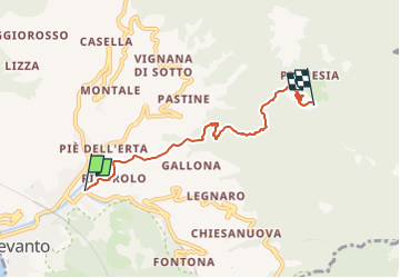
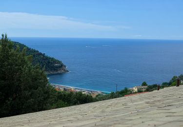
Randonnée A pied de 4,8 km à découvrir à Ligurie, La Spezia, Levanto. Cette randonnée est proposée par SityTrail - itinéraires balisés pédestres.
Description
relation mantained by AlfredoSP (CAI-SP)
Symbole: some old white red flag
Site web: https://www.cailaspezia.it/
Localisation
Pays :
Italie
Région :
Ligurie
Département/Province :
La Spezia
Commune :
Levanto
Localité :
Unknown
Départ:(Dec)
Départ:(UTM)
549758 ; 4891605 (32T) N.
Commentaires
Randonnées à proximité
![Randonnée Marche Vernazza - Rando cinq Terre 4ème jour Vernazza-Riomaggiore - Photo](https://media.geolcdn.com/t/375/260/f9331efa-b16c-4633-8239-c8a50683b624.jpg&format=jpg&maxdim=2)
![Marche Marche](https://static1.geolcdn.com/sitytour/trail-icons/101.png)
Rando cinq Terre 4ème jour Vernazza-Riomaggiore
Marche
Très difficile
(1)
Vernazza,
Ligurie,
La Spezia,
Italie
![](/images/other/stat-length.png)
12,4 km | 23 km-effort
4h 26min
![](https://static1.geolcdn.com/siteimages/upload/files/16400158638029165_repeat_loop_refresh_sync_direction_icon.png)
Non
![Randonnée Marche Levanto - Levanto - Vernazza 6.5.23 - Photo](https://media.geolcdn.com/t/375/260/0287dcd3-7795-4c8b-8f35-962c00e797c3.jpg&format=jpg&maxdim=2)
![Marche Marche](https://static1.geolcdn.com/sitytour/trail-icons/101.png)
Levanto - Vernazza 6.5.23
Marche
Difficile
Levanto,
Ligurie,
La Spezia,
Italie
![](/images/other/stat-length.png)
14,1 km | 23 km-effort
5h 0min
![](https://static1.geolcdn.com/siteimages/upload/files/16400158638029165_repeat_loop_refresh_sync_direction_icon.png)
Non
![Randonnée A pied Levanto - Alta Via delle 5 Terre: Foce di Dosso - Monte San Nicolao - Passo del Biscia - Photo](https://media.geolcdn.com/t/375/260/b0c8ac09-74d2-479f-a320-56bfabb8d7cd.jpeg&format=jpg&maxdim=2)
![A pied A pied](https://static1.geolcdn.com/sitytour/trail-icons/100.png)
Alta Via delle 5 Terre: Foce di Dosso - Monte San Nicolao - Passo del Biscia
A pied
Très difficile
Levanto,
Ligurie,
La Spezia,
Italie
![](/images/other/stat-length.png)
32 km | 48 km-effort
10h 51min
![](https://static1.geolcdn.com/siteimages/upload/files/16400158638029165_repeat_loop_refresh_sync_direction_icon.png)
Non
![Randonnée A pied Levanto - Vallesanta - Monte delle Streghe - Colletto - Photo](https://media.geolcdn.com/t/375/260/efa63fd2-8e4e-4cf6-bbf2-2f4e4541a575.jpeg&format=jpg&maxdim=2)
![A pied A pied](https://static1.geolcdn.com/sitytour/trail-icons/100.png)
Vallesanta - Monte delle Streghe - Colletto
A pied
Facile
Levanto,
Ligurie,
La Spezia,
Italie
![](/images/other/stat-length.png)
4,6 km | 9,5 km-effort
2h 9min
![](https://static1.geolcdn.com/siteimages/upload/files/16400158638029165_repeat_loop_refresh_sync_direction_icon.png)
Non
![Randonnée A pied Bonassola - Reggimonti - Monte Gaggi - S.P. 64 - Monte Grumo - Photo](https://media.geolcdn.com/t/375/260/53b7c24f-114d-496d-8324-7d9132d796d3.jpeg&format=jpg&maxdim=2)
![A pied A pied](https://static1.geolcdn.com/sitytour/trail-icons/100.png)
Reggimonti - Monte Gaggi - S.P. 64 - Monte Grumo
A pied
Facile
Bonassola,
Ligurie,
La Spezia,
Italie
![](/images/other/stat-length.png)
3,7 km | 7 km-effort
1h 34min
![](https://static1.geolcdn.com/siteimages/upload/files/16400158638029165_repeat_loop_refresh_sync_direction_icon.png)
Non
![Randonnée A pied Bonassola - Bonassola - Salto della Lepre - Pastorelli - Montaretto - Photo](https://media.geolcdn.com/t/375/260/a7cea6e7-bc07-4258-9020-ad0c6abe0784.jpeg&format=jpg&maxdim=2)
![A pied A pied](https://static1.geolcdn.com/sitytour/trail-icons/100.png)
Bonassola - Salto della Lepre - Pastorelli - Montaretto
A pied
Facile
Bonassola,
Ligurie,
La Spezia,
Italie
![](/images/other/stat-length.png)
3 km | 4,2 km-effort
57min
![](https://static1.geolcdn.com/siteimages/upload/files/16400158638029165_repeat_loop_refresh_sync_direction_icon.png)
Non
![Randonnée A pied Framura - Vandarecca - Montaretto - Reggimonti – Bivio AV5T - Photo](https://media.geolcdn.com/t/375/260/433b5181-ce40-4552-b8f8-d309475f0ca2.jpeg&format=jpg&maxdim=2)
![A pied A pied](https://static1.geolcdn.com/sitytour/trail-icons/100.png)
Vandarecca - Montaretto - Reggimonti – Bivio AV5T
A pied
Facile
Framura,
Ligurie,
La Spezia,
Italie
![](/images/other/stat-length.png)
6 km | 11,9 km-effort
2h 42min
![](https://static1.geolcdn.com/siteimages/upload/files/16400158638029165_repeat_loop_refresh_sync_direction_icon.png)
Non
![Randonnée A pied Levanto - Il Termine – Mad.di Soviore – Colla di Gritta – S.Antonio al Mesco - Photo](https://media.geolcdn.com/t/375/260/7d93da1b-0b41-4fef-acc9-26fc84562262.jpeg&format=jpg&maxdim=2)
![A pied A pied](https://static1.geolcdn.com/sitytour/trail-icons/100.png)
Il Termine – Mad.di Soviore – Colla di Gritta – S.Antonio al Mesco
A pied
Facile
Levanto,
Ligurie,
La Spezia,
Italie
![](/images/other/stat-length.png)
7,4 km | 12,6 km-effort
2h 52min
![](https://static1.geolcdn.com/siteimages/upload/files/16400158638029165_repeat_loop_refresh_sync_direction_icon.png)
Non
![Randonnée A pied Levanto - Levanto - Montale - Foce di Montale - Valle Carbonetta - Photo](https://media.geolcdn.com/t/375/260/f14c232d-65b5-4ec2-b169-eb236882792a.jpeg&format=jpg&maxdim=2)
![A pied A pied](https://static1.geolcdn.com/sitytour/trail-icons/100.png)
Levanto - Montale - Foce di Montale - Valle Carbonetta
A pied
Facile
Levanto,
Ligurie,
La Spezia,
Italie
![](/images/other/stat-length.png)
6,3 km | 11,5 km-effort
2h 37min
![](https://static1.geolcdn.com/siteimages/upload/files/16400158638029165_repeat_loop_refresh_sync_direction_icon.png)
Non