![](/images/other/stat-length.png)
![Randonnée A pied Petit-Canal - Boucle de Deville - Photo](https://media.geolcdn.com/t/1900/400/ext.pjpeg?maxdim=2&url=https%3A%2F%2Fstatic1.geolcdn.com%2Fsiteimages%2Fupload%2Ffiles%2F1545311037marcheuse_200dpi.jpg)
Boucle de Deville
SityTrail - itinéraires balisés pédestres
Tous les sentiers balisés d’Europe GUIDE+
![Longueur](/images/other/stat-length.png)
Longueur
5,7 km
![Altitude max](https://static1.geolcdn.com/siteimages/upload/files/1508320355ic_sort_altitude_max_24dp.png)
Altitude max
40 m
![Dénivelé positif](https://static1.geolcdn.com/siteimages/upload/files/1508320355ic_sort_den_pos_24dp.png)
Dénivelé positif
54 m
![Km-Effort](/images/other/stat-length.png)
Km-Effort
6,4 km
![Altitude min](https://static1.geolcdn.com/siteimages/upload/files/1508320355ic_sort_altitude_min_24dp.png)
Altitude min
8 m
![Dénivelé négatif](https://static1.geolcdn.com/siteimages/upload/files/1508320355ic_sort_den_neg_24dp.png)
Dénivelé négatif
55 m
![Boucle](https://static1.geolcdn.com/siteimages/upload/files/16400158638029165_repeat_loop_refresh_sync_direction_icon.png)
Boucle
Non
Balise
Date de création :
2022-02-15 02:49:19.426
Dernière modification :
2022-03-02 11:40:14.249
![A pied](https://static1.geolcdn.com/sitytour/trail-icons/100.png)
1h27
Difficulté : Facile
![Scannez ce code QR pour ouvrir la randonnée dans l'application SityTrail](https://capi.geolives.com/qq0zvz2zws4bq2lad0pu/sitytour/trails/3114273/qr.png?size=200)
Application GPS de randonnée GRATUITE
À propos
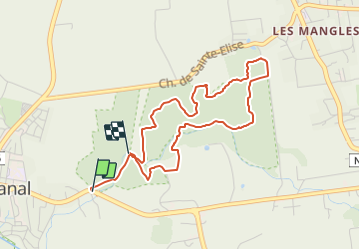
Randonnée A pied de 5,7 km à découvrir à Guadeloupe, Inconnu, Petit-Canal. Cette randonnée est proposée par SityTrail - itinéraires balisés pédestres.
Description
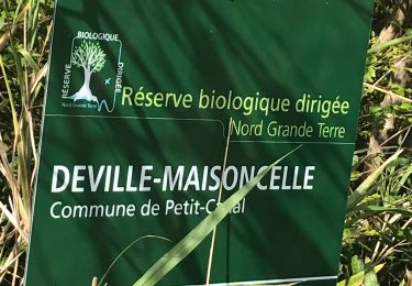
Randonnée créée par Forêt départementale de Deville Maisoncelle.
Symbole: yellow bar on top, blue bar below
Localisation
Pays :
France
Région :
Guadeloupe
Département/Province :
Inconnu
Commune :
Petit-Canal
Localité :
Unknown
Départ:(Dec)
Départ:(UTM)
662473 ; 1811286 (20Q) N.
Commentaires
Randonnées à proximité
![Randonnée Marche Petit-Canal - Boucle de Deville - Photo](https://media.geolcdn.com/t/375/260/5dd0b675-d7cc-455e-95a8-7e0a8574469e.jpg&format=jpg&maxdim=2)
![Marche Marche](https://static1.geolcdn.com/sitytour/trail-icons/101.png)
Boucle de Deville
Marche
Très facile
Petit-Canal,
Guadeloupe,
Inconnu,
France
![](/images/other/stat-length.png)
6,5 km | 7,5 km-effort
1h 24min
![](https://static1.geolcdn.com/siteimages/upload/files/16400158638029165_repeat_loop_refresh_sync_direction_icon.png)
Oui
![Randonnée Marche Petit-Canal - La forêt de Deville - Photo](https://media.geolcdn.com/t/375/260/d9b63cb4-60f1-4810-a1d4-89408f565e18.jpg&format=jpg&maxdim=2)
![Marche Marche](https://static1.geolcdn.com/sitytour/trail-icons/101.png)
La forêt de Deville
Marche
Petit-Canal,
Guadeloupe,
Inconnu,
France
![](/images/other/stat-length.png)
7,9 km | 9 km-effort
2h 11min
![](https://static1.geolcdn.com/siteimages/upload/files/16400158638029165_repeat_loop_refresh_sync_direction_icon.png)
Oui
![Randonnée Marche Port-Louis - Tour du lac de gaschet 29 01 23 - Photo](https://media.geolcdn.com/t/375/260/ext.jpg?maxdim=2&url=https%3A%2F%2Fstatic1.geolcdn.com%2Fsiteimages%2Fupload%2Ffiles%2F1553511878bg_sport_marche.png)
![Marche Marche](https://static1.geolcdn.com/sitytour/trail-icons/101.png)
Tour du lac de gaschet 29 01 23
Marche
Moyen
Port-Louis,
Guadeloupe,
Inconnu,
France
![](/images/other/stat-length.png)
9,7 km | 10,6 km-effort
2h 7min
![](https://static1.geolcdn.com/siteimages/upload/files/16400158638029165_repeat_loop_refresh_sync_direction_icon.png)
Non
![Randonnée Trail Petit-Canal - Forêt de Deville - Photo](https://media.geolcdn.com/t/375/260/ext.jpg?maxdim=2&url=https%3A%2F%2Fstatic1.geolcdn.com%2Fsiteimages%2Fupload%2Ffiles%2F1524743154running.jpg)
![Trail Trail](https://static1.geolcdn.com/sitytour/trail-icons/104.png)
Forêt de Deville
Trail
Difficile
Petit-Canal,
Guadeloupe,
Inconnu,
France
![](/images/other/stat-length.png)
14 km | 15,9 km-effort
2h 14min
![](https://static1.geolcdn.com/siteimages/upload/files/16400158638029165_repeat_loop_refresh_sync_direction_icon.png)
Oui
![Randonnée Marche Petit-Canal - Foret de Deville - Photo](https://media.geolcdn.com/t/375/260/ext.jpg?maxdim=2&url=https%3A%2F%2Fstatic1.geolcdn.com%2Fsiteimages%2Fupload%2Ffiles%2F1553511878bg_sport_marche.png)
![Marche Marche](https://static1.geolcdn.com/sitytour/trail-icons/101.png)
Foret de Deville
Marche
Difficile
Petit-Canal,
Guadeloupe,
Inconnu,
France
![](/images/other/stat-length.png)
8 km | 9,1 km-effort
1h 40min
![](https://static1.geolcdn.com/siteimages/upload/files/16400158638029165_repeat_loop_refresh_sync_direction_icon.png)
Oui
![Randonnée Marche Petit-Canal - Sentier Beautiran - Photo](https://media.geolcdn.com/t/375/260/ext.jpg?maxdim=2&url=https%3A%2F%2Fstatic1.geolcdn.com%2Fsiteimages%2Fupload%2Ffiles%2F1553511878bg_sport_marche.png)
![Marche Marche](https://static1.geolcdn.com/sitytour/trail-icons/101.png)
Sentier Beautiran
Marche
Facile
Petit-Canal,
Guadeloupe,
Inconnu,
France
![](/images/other/stat-length.png)
13,9 km | 15,7 km-effort
4h 36min
![](https://static1.geolcdn.com/siteimages/upload/files/16400158638029165_repeat_loop_refresh_sync_direction_icon.png)
Oui
![Randonnée Marche Morne-à-l'Eau - La Mangrove de Petit Canal - Photo](https://media.geolcdn.com/t/375/260/ext.jpg?maxdim=2&url=https%3A%2F%2Fstatic1.geolcdn.com%2Fsiteimages%2Fupload%2Ffiles%2F1553511878bg_sport_marche.png)
![Marche Marche](https://static1.geolcdn.com/sitytour/trail-icons/101.png)
La Mangrove de Petit Canal
Marche
Très facile
Morne-à-l'Eau,
Guadeloupe,
Inconnu,
France
![](/images/other/stat-length.png)
16,3 km | 16,8 km-effort
3h 45min
![](https://static1.geolcdn.com/siteimages/upload/files/16400158638029165_repeat_loop_refresh_sync_direction_icon.png)
Oui
![Randonnée Marche Petit-Canal - beautiran - Photo](https://media.geolcdn.com/t/375/260/ext.jpg?maxdim=2&url=https%3A%2F%2Fservices.sitytrail.com%2FGeolivesWS%2FDownloadMedia.ashx%3FTrailID%3D285305%26Media%3Dfix__20140416113230.jpg)
![Marche Marche](https://static1.geolcdn.com/sitytour/trail-icons/101.png)
beautiran
Marche
Très facile
(1)
Petit-Canal,
Guadeloupe,
Inconnu,
France
![](/images/other/stat-length.png)
9,7 km | 10,9 km-effort
3h 15min
![](https://static1.geolcdn.com/siteimages/upload/files/16400158638029165_repeat_loop_refresh_sync_direction_icon.png)
Oui
![Randonnée Marche Port-Louis - Boucle de Gachet - Photo](https://media.geolcdn.com/t/375/260/ext.jpg?maxdim=2&url=https%3A%2F%2Fstatic1.geolcdn.com%2Fsiteimages%2Fupload%2Ffiles%2F1553511878bg_sport_marche.png)
![Marche Marche](https://static1.geolcdn.com/sitytour/trail-icons/101.png)
Boucle de Gachet
Marche
Moyen
Port-Louis,
Guadeloupe,
Inconnu,
France
![](/images/other/stat-length.png)
13,2 km | 14,6 km-effort
4h 55min
![](https://static1.geolcdn.com/siteimages/upload/files/16400158638029165_repeat_loop_refresh_sync_direction_icon.png)
Oui