![](/images/other/stat-length.png)
![Randonnée A pied Asté - Sentier du Pacte des Loups - Photo](https://media.geolcdn.com/t/1900/400/ext.pjpeg?maxdim=2&url=https%3A%2F%2Fstatic1.geolcdn.com%2Fsiteimages%2Fupload%2Ffiles%2F1545311037marcheuse_200dpi.jpg)
Sentier du Pacte des Loups
SityTrail - itinéraires balisés pédestres
Tous les sentiers balisés d’Europe GUIDE+
![Longueur](/images/other/stat-length.png)
Longueur
12,3 km
![Altitude max](https://static1.geolcdn.com/siteimages/upload/files/1508320355ic_sort_altitude_max_24dp.png)
Altitude max
1466 m
![Dénivelé positif](https://static1.geolcdn.com/siteimages/upload/files/1508320355ic_sort_den_pos_24dp.png)
Dénivelé positif
173 m
![Km-Effort](/images/other/stat-length.png)
Km-Effort
16,8 km
![Altitude min](https://static1.geolcdn.com/siteimages/upload/files/1508320355ic_sort_altitude_min_24dp.png)
Altitude min
813 m
![Dénivelé négatif](https://static1.geolcdn.com/siteimages/upload/files/1508320355ic_sort_den_neg_24dp.png)
Dénivelé négatif
818 m
![Boucle](https://static1.geolcdn.com/siteimages/upload/files/16400158638029165_repeat_loop_refresh_sync_direction_icon.png)
Boucle
Non
Balise
Date de création :
2022-02-15 02:29:34.76
Dernière modification :
2022-03-02 11:08:46.057
![A pied](https://static1.geolcdn.com/sitytour/trail-icons/100.png)
3h48
Difficulté : Facile
![Scannez ce code QR pour ouvrir la randonnée dans l'application SityTrail](https://capi.geolives.com/qq0zvz2zws4bq2lad0pu/sitytour/trails/3113976/qr.png?size=200)
Application GPS de randonnée GRATUITE
À propos
Randonnée A pied de 12,3 km à découvrir à Occitanie, Hautes-Pyrénées, Asté. Cette randonnée est proposée par SityTrail - itinéraires balisés pédestres.
Description
Symbole: tête de loup jaune sur fond bleu
Localisation
Pays :
France
Région :
Occitanie
Département/Province :
Hautes-Pyrénées
Commune :
Asté
Localité :
Unknown
Départ:(Dec)
Départ:(UTM)
277367 ; 4762957 (31T) N.
Commentaires
Randonnées à proximité
![Randonnée Marche Esparros - Du Signal de Bassia vers le col de Beyrède par la crête sud-est et le Pas de Bassia - Photo](https://media.geolcdn.com/t/375/260/ext.jpg?maxdim=2&url=https%3A%2F%2Fstatic1.geolcdn.com%2Fsiteimages%2Fupload%2Ffiles%2F1553511878bg_sport_marche.png)
![Marche Marche](https://static1.geolcdn.com/sitytour/trail-icons/101.png)
Du Signal de Bassia vers le col de Beyrède par la crête sud-est et le Pas de ...
Marche
Moyen
(9)
Esparros,
Occitanie,
Hautes-Pyrénées,
France
![](/images/other/stat-length.png)
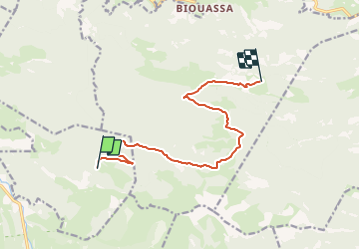
3,2 km | 5,1 km-effort
48min
![](https://static1.geolcdn.com/siteimages/upload/files/16400158638029165_repeat_loop_refresh_sync_direction_icon.png)
Non
![Randonnée Marche Campan - La soula de Tournes - Photo](https://media.geolcdn.com/t/375/260/ext.jpg?maxdim=2&url=https%3A%2F%2Fstatic1.geolcdn.com%2Fsiteimages%2Fupload%2Ffiles%2F1553511878bg_sport_marche.png)
![Marche Marche](https://static1.geolcdn.com/sitytour/trail-icons/101.png)
La soula de Tournes
Marche
Facile
(1)
Campan,
Occitanie,
Hautes-Pyrénées,
France
![](/images/other/stat-length.png)
7,7 km | 11,3 km-effort
2h 21min
![](https://static1.geolcdn.com/siteimages/upload/files/16400158638029165_repeat_loop_refresh_sync_direction_icon.png)
Oui
![Randonnée Marche Beyrède-Jumet-Camous - Signal de Bassia de Hèche - Photo](https://media.geolcdn.com/t/375/260/ext.jpg?maxdim=2&url=https%3A%2F%2Fservices.sitytrail.com%2FGeolivesWS%2FDownloadMedia.ashx%3FTrailID%3D101301%26Media%3D796_2.jpg)
![Marche Marche](https://static1.geolcdn.com/sitytour/trail-icons/101.png)
Signal de Bassia de Hèche
Marche
Très difficile
(1)
Beyrède-Jumet-Camous,
Occitanie,
Hautes-Pyrénées,
France
![](/images/other/stat-length.png)
3,1 km | 8,2 km-effort
3h 30min
![](https://static1.geolcdn.com/siteimages/upload/files/16400158638029165_repeat_loop_refresh_sync_direction_icon.png)
Non
![Randonnée A pied Campan - Boucle d'Espiadet - Photo](https://media.geolcdn.com/t/375/260/0625399b-d0a9-424d-94f3-d72094f23909.jpeg&format=jpg&maxdim=2)
![A pied A pied](https://static1.geolcdn.com/sitytour/trail-icons/100.png)
Boucle d'Espiadet
A pied
Facile
Campan,
Occitanie,
Hautes-Pyrénées,
France
![](/images/other/stat-length.png)
4,2 km | 6,3 km-effort
1h 25min
![](https://static1.geolcdn.com/siteimages/upload/files/16400158638029165_repeat_loop_refresh_sync_direction_icon.png)
Non
![Randonnée Marche Beyrède-Jumet-Camous - Le signal de Bassia depuis le col de Beyrède - Photo](https://media.geolcdn.com/t/375/260/ext.jpg?maxdim=2&url=https%3A%2F%2Fstatic1.geolcdn.com%2Fsiteimages%2Fupload%2Ffiles%2F1553511878bg_sport_marche.png)
![Marche Marche](https://static1.geolcdn.com/sitytour/trail-icons/101.png)
Le signal de Bassia depuis le col de Beyrède
Marche
Moyen
(3)
Beyrède-Jumet-Camous,
Occitanie,
Hautes-Pyrénées,
France
![](/images/other/stat-length.png)
4,1 km | 10,3 km-effort
1h 53min
![](https://static1.geolcdn.com/siteimages/upload/files/16400158638029165_repeat_loop_refresh_sync_direction_icon.png)
Oui
![Randonnée Marche Campan - Pic de Bassia, Pic du Castillon, Pic de Paou - Photo](https://media.geolcdn.com/t/375/260/ext.jpg?maxdim=2&url=https%3A%2F%2Fstatic1.geolcdn.com%2Fsiteimages%2Fupload%2Ffiles%2F1553511878bg_sport_marche.png)
![Marche Marche](https://static1.geolcdn.com/sitytour/trail-icons/101.png)
Pic de Bassia, Pic du Castillon, Pic de Paou
Marche
Très facile
(1)
Campan,
Occitanie,
Hautes-Pyrénées,
France
![](/images/other/stat-length.png)
10,3 km | 22 km-effort
3h 52min
![](https://static1.geolcdn.com/siteimages/upload/files/16400158638029165_repeat_loop_refresh_sync_direction_icon.png)
Non
![Randonnée Marche Esparros - Pacte des loups - Photo](https://media.geolcdn.com/t/375/260/ext.jpg?maxdim=2&url=https%3A%2F%2Fstatic1.geolcdn.com%2Fsiteimages%2Fupload%2Ffiles%2F1553511878bg_sport_marche.png)
![Marche Marche](https://static1.geolcdn.com/sitytour/trail-icons/101.png)
Pacte des loups
Marche
Moyen
(2)
Esparros,
Occitanie,
Hautes-Pyrénées,
France
![](/images/other/stat-length.png)
10,9 km | 18 km-effort
Inconnu
![](https://static1.geolcdn.com/siteimages/upload/files/16400158638029165_repeat_loop_refresh_sync_direction_icon.png)
Oui
![Randonnée Marche Campan - G2B payolle gleyse 2024 - Photo](https://media.geolcdn.com/t/375/260/6d136f9a-e460-46c2-88bb-41345f157e89.jpg&format=jpg&maxdim=2)
![Marche Marche](https://static1.geolcdn.com/sitytour/trail-icons/101.png)
G2B payolle gleyse 2024
Marche
Très difficile
Campan,
Occitanie,
Hautes-Pyrénées,
France
![](/images/other/stat-length.png)
10,9 km | 20 km-effort
6h 57min
![](https://static1.geolcdn.com/siteimages/upload/files/16400158638029165_repeat_loop_refresh_sync_direction_icon.png)
Oui
![Randonnée Marche Beyrède-Jumet-Camous - Signal de Bassia via le Cap de Paou - Photo](https://media.geolcdn.com/t/375/260/0052c0ce-f697-4df9-9476-248b8662c9ce.jpg&format=jpg&maxdim=2)
![Marche Marche](https://static1.geolcdn.com/sitytour/trail-icons/101.png)
Signal de Bassia via le Cap de Paou
Marche
Moyen
Beyrède-Jumet-Camous,
Occitanie,
Hautes-Pyrénées,
France
![](/images/other/stat-length.png)
7,5 km | 15,7 km-effort
3h 33min
![](https://static1.geolcdn.com/siteimages/upload/files/16400158638029165_repeat_loop_refresh_sync_direction_icon.png)
Oui