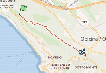
![](/images/other/stat-length.png)
![Randonnée A pied Trieste - Sentiero Nicolò Cobolli - Photo](https://media.geolcdn.com/t/1900/400/798dfb9f-7a91-4fb1-b95a-f5e0edcbcebb.jpeg&format=pjpeg&maxdim=2)
Sentiero Nicolò Cobolli
SityTrail - itinéraires balisés pédestres
Tous les sentiers balisés d’Europe GUIDE+
![Longueur](/images/other/stat-length.png)
![Altitude max](https://static1.geolcdn.com/siteimages/upload/files/1508320355ic_sort_altitude_max_24dp.png)
![Dénivelé positif](https://static1.geolcdn.com/siteimages/upload/files/1508320355ic_sort_den_pos_24dp.png)
![Km-Effort](/images/other/stat-length.png)
![Altitude min](https://static1.geolcdn.com/siteimages/upload/files/1508320355ic_sort_altitude_min_24dp.png)
![Dénivelé négatif](https://static1.geolcdn.com/siteimages/upload/files/1508320355ic_sort_den_neg_24dp.png)
![Boucle](https://static1.geolcdn.com/siteimages/upload/files/16400158638029165_repeat_loop_refresh_sync_direction_icon.png)
![A pied](https://static1.geolcdn.com/sitytour/trail-icons/100.png)
1h25
Difficulté : Facile
![Scannez ce code QR pour ouvrir la randonnée dans l'application SityTrail](https://capi.geolives.com/qq0zvz2zws4bq2lad0pu/sitytour/trails/3113091/qr.png?size=200)
Application GPS de randonnée GRATUITE
À propos
Randonnée A pied de 4,1 km à découvrir à Frioul-Vénétie julienne, Inconnu, Trieste. Cette randonnée est proposée par SityTrail - itinéraires balisés pédestres.
Description
Randonnée créée par Commissione Giulio Carnica Sentieri, Rifugi e Opere Alpine.
Borgo San Nazario - Monte Gurca - Poggioreale - Sella di Opicina
Symbole: 12 on white red flag
Site web: http://www.cai-fvg.it/sentieri-cai-fvg/sentieri-cai-fvg-settore-0-carso/
Localisation
Commentaires
Randonnées à proximité
![Randonnée A pied Monrupino / Repentabor - (SI A25) Repen - Basovizza / Bazovica - Photo](https://media.geolcdn.com/t/375/260/d21558da-0d2a-442b-b36f-848e0ff1e137.jpeg&format=jpg&maxdim=2)
![A pied A pied](https://static1.geolcdn.com/sitytour/trail-icons/100.png)
A pied
![](/images/other/stat-length.png)
![](https://static1.geolcdn.com/siteimages/upload/files/16400158638029165_repeat_loop_refresh_sync_direction_icon.png)
![Randonnée A pied Trieste - IT-26 - Photo](https://media.geolcdn.com/t/375/260/f5edd303-9734-4978-b920-7283e0cdb8f4.jpeg&format=jpg&maxdim=2)
![A pied A pied](https://static1.geolcdn.com/sitytour/trail-icons/100.png)
A pied
![](/images/other/stat-length.png)
![](https://static1.geolcdn.com/siteimages/upload/files/16400158638029165_repeat_loop_refresh_sync_direction_icon.png)
![Randonnée A pied Trieste - IT-43 - Photo](https://media.geolcdn.com/t/375/260/48d0de8f-089a-42fc-89c5-05dbbe87122f.jpeg&format=jpg&maxdim=2)
![A pied A pied](https://static1.geolcdn.com/sitytour/trail-icons/100.png)
A pied
![](/images/other/stat-length.png)
![](https://static1.geolcdn.com/siteimages/upload/files/16400158638029165_repeat_loop_refresh_sync_direction_icon.png)
![Randonnée A pied Trieste - IT-2 - Photo](https://media.geolcdn.com/t/375/260/798dfb9f-7a91-4fb1-b95a-f5e0edcbcebb.jpeg&format=jpg&maxdim=2)
![A pied A pied](https://static1.geolcdn.com/sitytour/trail-icons/100.png)
A pied
![](/images/other/stat-length.png)
![](https://static1.geolcdn.com/siteimages/upload/files/16400158638029165_repeat_loop_refresh_sync_direction_icon.png)
![Randonnée A pied Trieste - IT-11 - Photo](https://media.geolcdn.com/t/375/260/6c573766-6c20-473e-98dc-5c47bb3a3824.jpeg&format=jpg&maxdim=2)
![A pied A pied](https://static1.geolcdn.com/sitytour/trail-icons/100.png)
A pied
![](/images/other/stat-length.png)
![](https://static1.geolcdn.com/siteimages/upload/files/16400158638029165_repeat_loop_refresh_sync_direction_icon.png)
![Randonnée A pied Trieste - Aurisina - Opicina - Photo](https://media.geolcdn.com/t/375/260/798dfb9f-7a91-4fb1-b95a-f5e0edcbcebb.jpeg&format=jpg&maxdim=2)
![A pied A pied](https://static1.geolcdn.com/sitytour/trail-icons/100.png)
A pied
![](/images/other/stat-length.png)
![](https://static1.geolcdn.com/siteimages/upload/files/16400158638029165_repeat_loop_refresh_sync_direction_icon.png)
![Randonnée A pied Trieste - IT-10 - Photo](https://media.geolcdn.com/t/375/260/0c73d411-d32c-4403-9375-2d37308a7258.jpeg&format=jpg&maxdim=2)
![A pied A pied](https://static1.geolcdn.com/sitytour/trail-icons/100.png)
A pied
![](/images/other/stat-length.png)
![](https://static1.geolcdn.com/siteimages/upload/files/16400158638029165_repeat_loop_refresh_sync_direction_icon.png)
![Randonnée A pied Trieste - IT-19 - Photo](https://media.geolcdn.com/t/375/260/cd4eb0ba-c064-491b-ba04-907e4fb2bffb.jpeg&format=jpg&maxdim=2)
![A pied A pied](https://static1.geolcdn.com/sitytour/trail-icons/100.png)
A pied
![](/images/other/stat-length.png)
![](https://static1.geolcdn.com/siteimages/upload/files/16400158638029165_repeat_loop_refresh_sync_direction_icon.png)
![Randonnée A pied Trieste - Strada Basovizzana - Photo](https://media.geolcdn.com/t/375/260/d21558da-0d2a-442b-b36f-848e0ff1e137.jpeg&format=jpg&maxdim=2)
![A pied A pied](https://static1.geolcdn.com/sitytour/trail-icons/100.png)
A pied
![](/images/other/stat-length.png)
![](https://static1.geolcdn.com/siteimages/upload/files/16400158638029165_repeat_loop_refresh_sync_direction_icon.png)