![](/images/other/stat-length.png)
![Randonnée A pied Logonna-Daoulas - Sentier Côtier - Photo](https://media.geolcdn.com/t/1900/400/5cd226de-ab15-485c-ad56-76bdfb355d74.jpeg&format=pjpeg&maxdim=2)
Sentier Côtier
SityTrail - itinéraires balisés pédestres
Tous les sentiers balisés d’Europe GUIDE+
![Longueur](/images/other/stat-length.png)
Longueur
9,7 km
![Altitude max](https://static1.geolcdn.com/siteimages/upload/files/1508320355ic_sort_altitude_max_24dp.png)
Altitude max
29 m
![Dénivelé positif](https://static1.geolcdn.com/siteimages/upload/files/1508320355ic_sort_den_pos_24dp.png)
Dénivelé positif
151 m
![Km-Effort](/images/other/stat-length.png)
Km-Effort
11,6 km
![Altitude min](https://static1.geolcdn.com/siteimages/upload/files/1508320355ic_sort_altitude_min_24dp.png)
Altitude min
0 m
![Dénivelé négatif](https://static1.geolcdn.com/siteimages/upload/files/1508320355ic_sort_den_neg_24dp.png)
Dénivelé négatif
141 m
![Boucle](https://static1.geolcdn.com/siteimages/upload/files/16400158638029165_repeat_loop_refresh_sync_direction_icon.png)
Boucle
Non
Balise
Date de création :
2022-02-14 23:37:05.522
Dernière modification :
2022-03-02 09:28:28.799
![A pied](https://static1.geolcdn.com/sitytour/trail-icons/100.png)
2h38
Difficulté : Facile
![Scannez ce code QR pour ouvrir la randonnée dans l'application SityTrail](https://capi.geolives.com/qq0zvz2zws4bq2lad0pu/sitytour/trails/3112606/qr.png?size=200)
Application GPS de randonnée GRATUITE
À propos
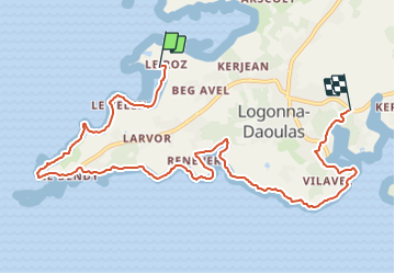
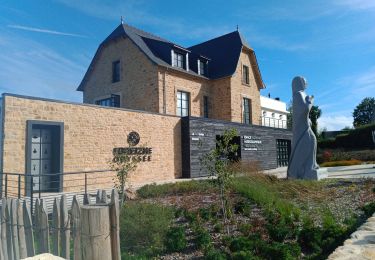
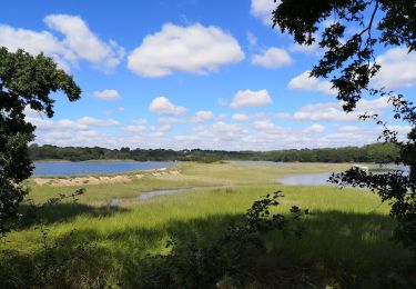
Randonnée A pied de 9,7 km à découvrir à Bretagne, Finistère, Logonna-Daoulas. Cette randonnée est proposée par SityTrail - itinéraires balisés pédestres.
Description
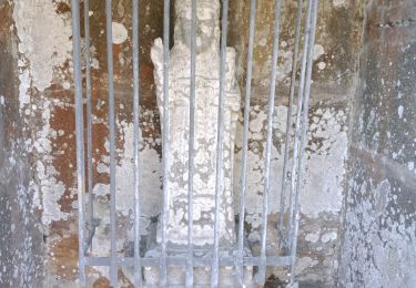
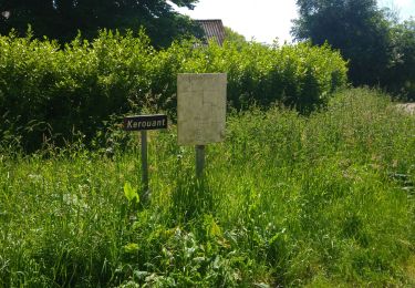
marquage rond jaune sur les panneaux;nom Sentier du Littoral sur Daoulas
Symbole: yellow bar
Localisation
Pays :
France
Région :
Bretagne
Département/Province :
Finistère
Commune :
Logonna-Daoulas
Localité :
Unknown
Départ:(Dec)
Départ:(UTM)
402338 ; 5353404 (30U) N.
Commentaires
Randonnées à proximité
![Randonnée Marche Landévennec - Le tour de Landévennec Boucle 21 km - Photo](https://media.geolcdn.com/t/375/260/b342935f-f644-482b-a93d-00e8e9a2fff9.jpg&format=jpg&maxdim=2)
![Marche Marche](https://static1.geolcdn.com/sitytour/trail-icons/101.png)
Le tour de Landévennec Boucle 21 km
Marche
Très difficile
Landévennec,
Bretagne,
Finistère,
France
![](/images/other/stat-length.png)
21 km | 28 km-effort
5h 10min
![](https://static1.geolcdn.com/siteimages/upload/files/16400158638029165_repeat_loop_refresh_sync_direction_icon.png)
Oui
![Randonnée Marche Landévennec - Landévennec - boucles locales et GR34 - 13.8km 250m 4h10 (35mn) - 2019 09 12 - Photo](https://media.geolcdn.com/t/375/260/ed0a847b-b2f3-4f8e-b6b5-8e6353637e62.jpg&format=jpg&maxdim=2)
![Marche Marche](https://static1.geolcdn.com/sitytour/trail-icons/101.png)
Landévennec - boucles locales et GR34 - 13.8km 250m 4h10 (35mn) - 2019 09 12
Marche
Facile
Landévennec,
Bretagne,
Finistère,
France
![](/images/other/stat-length.png)
13,8 km | 17,2 km-effort
4h 10min
![](https://static1.geolcdn.com/siteimages/upload/files/16400158638029165_repeat_loop_refresh_sync_direction_icon.png)
Oui
![Randonnée Marche Landévennec - LANDÉVENNEC - Photo](https://media.geolcdn.com/t/375/260/3aa9913a-4da7-4716-a24d-72b5f897ad92.jpg&format=jpg&maxdim=2)
![Marche Marche](https://static1.geolcdn.com/sitytour/trail-icons/101.png)
LANDÉVENNEC
Marche
Difficile
Landévennec,
Bretagne,
Finistère,
France
![](/images/other/stat-length.png)
19,4 km | 25 km-effort
4h 41min
![](https://static1.geolcdn.com/siteimages/upload/files/16400158638029165_repeat_loop_refresh_sync_direction_icon.png)
Non
![Randonnée Marche Plougastel-Daoulas - LOPERHET - Photo](https://media.geolcdn.com/t/375/260/d8291e88-a4dd-4120-98c4-dfa35d2cb0a1.jpg&format=jpg&maxdim=2)
![Marche Marche](https://static1.geolcdn.com/sitytour/trail-icons/101.png)
LOPERHET
Marche
Moyen
Plougastel-Daoulas,
Bretagne,
Finistère,
France
![](/images/other/stat-length.png)
14,3 km | 16,8 km-effort
3h 33min
![](https://static1.geolcdn.com/siteimages/upload/files/16400158638029165_repeat_loop_refresh_sync_direction_icon.png)
Oui
![Randonnée Marche Logonna-Daoulas - Circuit de l'anse de Pen Foul. Logona. 06/07/20 - Photo](https://media.geolcdn.com/t/375/260/1dda4c52-fb47-4e06-aa03-a8ba7d97f79b.jpg&format=jpg&maxdim=2)
![Marche Marche](https://static1.geolcdn.com/sitytour/trail-icons/101.png)
Circuit de l'anse de Pen Foul. Logona. 06/07/20
Marche
Très facile
(1)
Logonna-Daoulas,
Bretagne,
Finistère,
France
![](/images/other/stat-length.png)
5,6 km | 7 km-effort
1h 33min
![](https://static1.geolcdn.com/siteimages/upload/files/16400158638029165_repeat_loop_refresh_sync_direction_icon.png)
Non
![Randonnée Marche Dirinon - Kerouant - Photo](https://media.geolcdn.com/t/375/260/c5daeea4-78c6-4acb-9aea-43fa359a6d3b.jpg&format=jpg&maxdim=2)
![Marche Marche](https://static1.geolcdn.com/sitytour/trail-icons/101.png)
Kerouant
Marche
Très facile
(1)
Dirinon,
Bretagne,
Finistère,
France
![](/images/other/stat-length.png)
9,7 km | 11,4 km-effort
3h 20min
![](https://static1.geolcdn.com/siteimages/upload/files/16400158638029165_repeat_loop_refresh_sync_direction_icon.png)
Oui
![Randonnée Marche Daoulas - Pointe de Rosmelec.(19-02-17) - Photo](https://media.geolcdn.com/t/375/260/ext.jpg?maxdim=2&url=https%3A%2F%2Fservices.sitytrail.com%2FGeolivesWS%2FDownloadMedia.ashx%3FTrailID%3D701310%26Media%3Dfix__20170219163205.jpg)
![Marche Marche](https://static1.geolcdn.com/sitytour/trail-icons/101.png)
Pointe de Rosmelec.(19-02-17)
Marche
Moyen
Daoulas,
Bretagne,
Finistère,
France
![](/images/other/stat-length.png)
9,4 km | 11 km-effort
2h 37min
![](https://static1.geolcdn.com/siteimages/upload/files/16400158638029165_repeat_loop_refresh_sync_direction_icon.png)
Oui
![Randonnée Marche Landévennec - Presqu'île Crozon - Day 02 - Photo](https://media.geolcdn.com/t/375/260/ext.jpg?maxdim=2&url=https%3A%2F%2Fservices.sitytrail.com%2FGeolivesWS%2FDownloadMedia.ashx%3FTrailID%3D615620%26Media%3D20160816153425.jpg)
![Marche Marche](https://static1.geolcdn.com/sitytour/trail-icons/101.png)
Presqu'île Crozon - Day 02
Marche
Moyen
Landévennec,
Bretagne,
Finistère,
France
![](/images/other/stat-length.png)
23 km | 30 km-effort
5h 54min
![](https://static1.geolcdn.com/siteimages/upload/files/16400158638029165_repeat_loop_refresh_sync_direction_icon.png)
Non
![Randonnée Course à pied Hôpital-Camfrout - Footing au gîte de Guernevez 1 - Photo](https://media.geolcdn.com/t/375/260/ext.jpg?maxdim=2&url=https%3A%2F%2Fservices.sitytrail.com%2FGeolivesWS%2FDownloadMedia.ashx%3FTrailID%3D574034%26Media%3Dfix__20160522175226.jpg)
![Course à pied Course à pied](https://static1.geolcdn.com/sitytour/trail-icons/103.png)
Footing au gîte de Guernevez 1
Course à pied
Moyen
Hôpital-Camfrout,
Bretagne,
Finistère,
France
![](/images/other/stat-length.png)
4,7 km | 5,9 km-effort
45min
![](https://static1.geolcdn.com/siteimages/upload/files/16400158638029165_repeat_loop_refresh_sync_direction_icon.png)
Oui