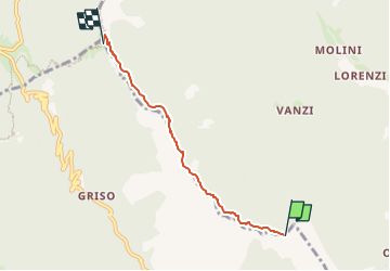
![](/images/other/stat-length.png)
![Randonnée A pied Posina - IT-511 - Photo](https://media.geolcdn.com/t/1900/400/ext.pjpeg?maxdim=2&url=https%3A%2F%2Fstatic1.geolcdn.com%2Fsiteimages%2Fupload%2Ffiles%2F1545311037marcheuse_200dpi.jpg)
IT-511
SityTrail - itinéraires balisés pédestres
Tous les sentiers balisés d’Europe GUIDE+
![Longueur](/images/other/stat-length.png)
![Altitude max](https://static1.geolcdn.com/siteimages/upload/files/1508320355ic_sort_altitude_max_24dp.png)
![Dénivelé positif](https://static1.geolcdn.com/siteimages/upload/files/1508320355ic_sort_den_pos_24dp.png)
![Km-Effort](/images/other/stat-length.png)
![Altitude min](https://static1.geolcdn.com/siteimages/upload/files/1508320355ic_sort_altitude_min_24dp.png)
![Dénivelé négatif](https://static1.geolcdn.com/siteimages/upload/files/1508320355ic_sort_den_neg_24dp.png)
![Boucle](https://static1.geolcdn.com/siteimages/upload/files/16400158638029165_repeat_loop_refresh_sync_direction_icon.png)
![A pied](https://static1.geolcdn.com/sitytour/trail-icons/100.png)
1h51
Difficulté : Facile
![Scannez ce code QR pour ouvrir la randonnée dans l'application SityTrail](https://capi.geolives.com/qq0zvz2zws4bq2lad0pu/sitytour/trails/3112464/qr.png?size=200)
Application GPS de randonnée GRATUITE
À propos
Randonnée A pied de 4,1 km à découvrir à Vénétie, Vicenza, Posina. Cette randonnée est proposée par SityTrail - itinéraires balisés pédestres.
Description
Sezione di Thiene del Club Alpino Italiano Montagna, Ambiente, Cultura, Condivisione, Formazione. Escursionismo, Alpinismo, Alpinismo Giovanile, Scialpinismo.
Site web: http://www.caisezionethiene.it/
Localisation
Commentaires
Randonnées à proximité
![Randonnée A pied Posina - Val Sorapache - Photo](https://media.geolcdn.com/t/375/260/26a9e899-d617-4f79-9d2b-6cb6dc3fa16a.jpeg&format=jpg&maxdim=2)
![A pied A pied](https://static1.geolcdn.com/sitytour/trail-icons/100.png)
![Randonnée A pied Posina - Val Caprara - Photo](https://media.geolcdn.com/t/375/260/27f940a5-64e3-4b79-9775-9d553d76ac5b.jpeg&format=jpg&maxdim=2)
![A pied A pied](https://static1.geolcdn.com/sitytour/trail-icons/100.png)
![Randonnée A pied Valli del Pasubio - Val Fontana d'Oro - Photo](https://media.geolcdn.com/t/375/260/8a2242b4-636d-4c9b-8ccd-012a3040b82f.jpeg&format=jpg&maxdim=2)
![A pied A pied](https://static1.geolcdn.com/sitytour/trail-icons/100.png)
A pied
![](/images/other/stat-length.png)
![](https://static1.geolcdn.com/siteimages/upload/files/16400158638029165_repeat_loop_refresh_sync_direction_icon.png)
![Randonnée A pied Trambileno - IT-E105 - Photo](https://media.geolcdn.com/t/375/260/a56f21b6-538e-415a-a162-c4eac1464ea7.jpeg&format=jpg&maxdim=2)
![A pied A pied](https://static1.geolcdn.com/sitytour/trail-icons/100.png)
A pied
![](/images/other/stat-length.png)
![](https://static1.geolcdn.com/siteimages/upload/files/16400158638029165_repeat_loop_refresh_sync_direction_icon.png)
![Randonnée A pied Trambileno - IT-E120 - Photo](https://media.geolcdn.com/t/375/260/bd378ab6-9a88-43dd-9c88-6ec0dad23644.jpeg&format=jpg&maxdim=2)
![A pied A pied](https://static1.geolcdn.com/sitytour/trail-icons/100.png)
A pied
![](/images/other/stat-length.png)
![](https://static1.geolcdn.com/siteimages/upload/files/16400158638029165_repeat_loop_refresh_sync_direction_icon.png)
![Randonnée A pied Posina - Sentiero C.A.I. 367, Via Ferrata Gaetano Falcipieri - Photo](https://media.geolcdn.com/t/375/260/fa398f1a-1ae2-4bb9-9c68-a1a23ee9359a.jpeg&format=jpg&maxdim=2)
![A pied A pied](https://static1.geolcdn.com/sitytour/trail-icons/100.png)
A pied
![](/images/other/stat-length.png)
![](https://static1.geolcdn.com/siteimages/upload/files/16400158638029165_repeat_loop_refresh_sync_direction_icon.png)
![Randonnée A pied Posina - Strada delle 52 gallerie - Photo](https://media.geolcdn.com/t/375/260/26a9e899-d617-4f79-9d2b-6cb6dc3fa16a.jpeg&format=jpg&maxdim=2)
![A pied A pied](https://static1.geolcdn.com/sitytour/trail-icons/100.png)
A pied
![](/images/other/stat-length.png)
![](https://static1.geolcdn.com/siteimages/upload/files/16400158638029165_repeat_loop_refresh_sync_direction_icon.png)
![Randonnée A pied Posina - Strada degli Scarubbi - Photo](https://media.geolcdn.com/t/375/260/26a9e899-d617-4f79-9d2b-6cb6dc3fa16a.jpeg&format=jpg&maxdim=2)
![A pied A pied](https://static1.geolcdn.com/sitytour/trail-icons/100.png)
A pied
![](/images/other/stat-length.png)
![](https://static1.geolcdn.com/siteimages/upload/files/16400158638029165_repeat_loop_refresh_sync_direction_icon.png)
![Randonnée A pied Posina - Fusine - Boalòn del Novegno - Photo](https://media.geolcdn.com/t/375/260/3068893e-c8c6-460c-afc2-c7135b626cd5.jpeg&format=jpg&maxdim=2)
![A pied A pied](https://static1.geolcdn.com/sitytour/trail-icons/100.png)
A pied
![](/images/other/stat-length.png)
![](https://static1.geolcdn.com/siteimages/upload/files/16400158638029165_repeat_loop_refresh_sync_direction_icon.png)