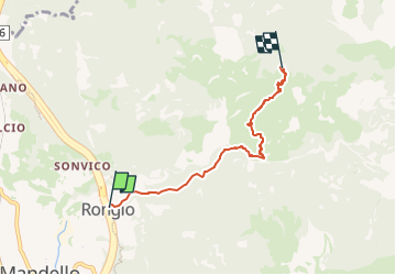
![](/images/other/stat-length.png)
![Randonnée A pied Mandello del Lario - Rongio - Alpe Cetra - Photo](https://media.geolcdn.com/t/1900/400/2ea09263-adcf-43af-82ec-804ee04f70c2.jpeg&format=pjpeg&maxdim=2)
Rongio - Alpe Cetra
SityTrail - itinéraires balisés pédestres
Tous les sentiers balisés d’Europe GUIDE+
![Longueur](/images/other/stat-length.png)
![Altitude max](https://static1.geolcdn.com/siteimages/upload/files/1508320355ic_sort_altitude_max_24dp.png)
![Dénivelé positif](https://static1.geolcdn.com/siteimages/upload/files/1508320355ic_sort_den_pos_24dp.png)
![Km-Effort](/images/other/stat-length.png)
![Altitude min](https://static1.geolcdn.com/siteimages/upload/files/1508320355ic_sort_altitude_min_24dp.png)
![Dénivelé négatif](https://static1.geolcdn.com/siteimages/upload/files/1508320355ic_sort_den_neg_24dp.png)
![Boucle](https://static1.geolcdn.com/siteimages/upload/files/16400158638029165_repeat_loop_refresh_sync_direction_icon.png)
![A pied](https://static1.geolcdn.com/sitytour/trail-icons/100.png)
2h31
Difficulté : Facile
![Scannez ce code QR pour ouvrir la randonnée dans l'application SityTrail](https://capi.geolives.com/qq0zvz2zws4bq2lad0pu/sitytour/trails/3111690/qr.png?size=200)
Application GPS de randonnée GRATUITE
À propos
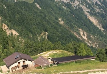
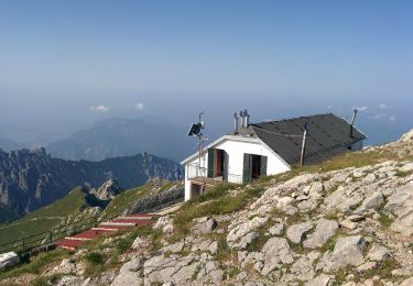
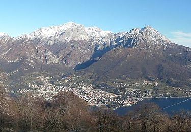
Randonnée A pied de 4,4 km à découvrir à Lombardie, Lecco, Mandello del Lario. Cette randonnée est proposée par SityTrail - itinéraires balisés pédestres.
Description
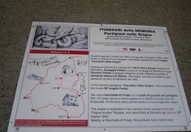
Randonnée créée par Club Alpino Italiano Grigne.
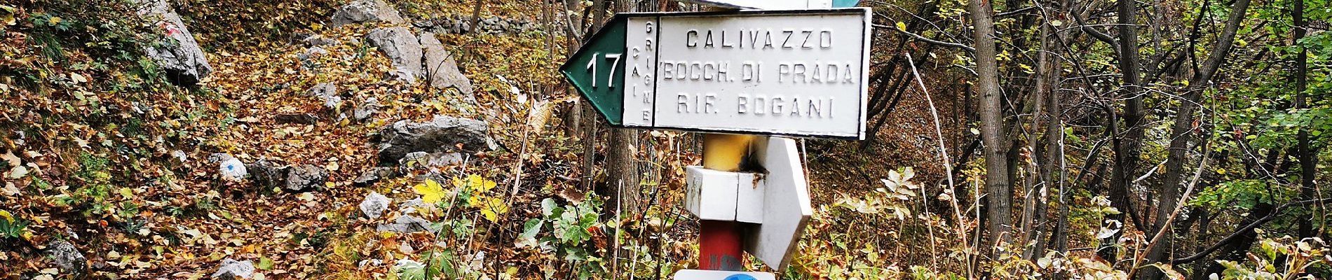
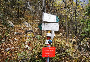
Rongio mt. 409 - La Gardata mt 1040 - Alpe Cetra mt 1093; F (facile); tempo di percorrenza: ore 2.15-2.45
Symbole: red-white-red vertical bars
Localisation
Commentaires
Randonnées à proximité
![Randonnée A pied Mandello del Lario - Traversata Alta delle Grigne - Photo](https://media.geolcdn.com/t/375/260/11177eda-b851-40ec-866f-92602503f3c4.jpeg&format=jpg&maxdim=2)
![A pied A pied](https://static1.geolcdn.com/sitytour/trail-icons/100.png)
A pied
![](/images/other/stat-length.png)
![](https://static1.geolcdn.com/siteimages/upload/files/16400158638029165_repeat_loop_refresh_sync_direction_icon.png)
![Randonnée A pied Pasturo - (SI D13S) Rifugio Luigi Brioschi - Pasturo - Photo](https://media.geolcdn.com/t/375/260/7321d799-4132-4e6e-b73d-c6a90ea1fe9a.jpeg&format=jpg&maxdim=2)
![A pied A pied](https://static1.geolcdn.com/sitytour/trail-icons/100.png)
A pied
![](/images/other/stat-length.png)
![](https://static1.geolcdn.com/siteimages/upload/files/16400158638029165_repeat_loop_refresh_sync_direction_icon.png)
![Randonnée A pied Esino Lario - Sentiero 37/39: Valle dei Mulini - Photo](https://media.geolcdn.com/t/375/260/30db3f75-6dc9-40e0-b854-90863f34942a.jpeg&format=jpg&maxdim=2)
![A pied A pied](https://static1.geolcdn.com/sitytour/trail-icons/100.png)
A pied
![](/images/other/stat-length.png)
![](https://static1.geolcdn.com/siteimages/upload/files/16400158638029165_repeat_loop_refresh_sync_direction_icon.png)
![Randonnée A pied Mandello del Lario - Era - Via del Caminetto - Photo](https://media.geolcdn.com/t/375/260/2e2ee11b-b7f6-4a45-b404-b88cbf397e55.jpeg&format=jpg&maxdim=2)
![A pied A pied](https://static1.geolcdn.com/sitytour/trail-icons/100.png)
A pied
![](/images/other/stat-length.png)
![](https://static1.geolcdn.com/siteimages/upload/files/16400158638029165_repeat_loop_refresh_sync_direction_icon.png)
![Randonnée A pied Mandello del Lario - Mandello - Bocchetta di Prada - Photo](https://media.geolcdn.com/t/375/260/2ea09263-adcf-43af-82ec-804ee04f70c2.jpeg&format=jpg&maxdim=2)
![A pied A pied](https://static1.geolcdn.com/sitytour/trail-icons/100.png)
A pied
![](/images/other/stat-length.png)
![](https://static1.geolcdn.com/siteimages/upload/files/16400158638029165_repeat_loop_refresh_sync_direction_icon.png)
![Randonnée A pied Esino Lario - Cresta di Piancaformia - Rifugio Brioschi - Photo](https://media.geolcdn.com/t/375/260/0896d105-b16b-4380-91d3-843c54d09825.jpeg&format=jpg&maxdim=2)
![A pied A pied](https://static1.geolcdn.com/sitytour/trail-icons/100.png)
A pied
![](/images/other/stat-length.png)
![](https://static1.geolcdn.com/siteimages/upload/files/16400158638029165_repeat_loop_refresh_sync_direction_icon.png)
![Randonnée A pied Mandello del Lario - Sentiero 13: Rongio - Rifugio Rosalba per la Val Portorella - Photo](https://media.geolcdn.com/t/375/260/75ba34b0-d8d7-4542-992d-0032c576acf7.jpeg&format=jpg&maxdim=2)
![A pied A pied](https://static1.geolcdn.com/sitytour/trail-icons/100.png)
A pied
![](/images/other/stat-length.png)
![](https://static1.geolcdn.com/siteimages/upload/files/16400158638029165_repeat_loop_refresh_sync_direction_icon.png)
![Randonnée A pied Magreglio - Sentiero del Tivano - Photo](https://media.geolcdn.com/t/375/260/5a0592bb-84e2-472c-bd66-168c035bd89c.jpeg&format=jpg&maxdim=2)
![A pied A pied](https://static1.geolcdn.com/sitytour/trail-icons/100.png)
A pied
![](/images/other/stat-length.png)
![](https://static1.geolcdn.com/siteimages/upload/files/16400158638029165_repeat_loop_refresh_sync_direction_icon.png)
![Randonnée A pied Mandello del Lario - Maggiana/Rongio - Colonghei - Rifugio Rosalba - Photo](https://media.geolcdn.com/t/375/260/d829d509-1b5d-4d4f-8330-4df05d7a2fe0.jpeg&format=jpg&maxdim=2)
![A pied A pied](https://static1.geolcdn.com/sitytour/trail-icons/100.png)
A pied
![](/images/other/stat-length.png)
![](https://static1.geolcdn.com/siteimages/upload/files/16400158638029165_repeat_loop_refresh_sync_direction_icon.png)