![](/images/other/stat-length.png)
![Randonnée A pied Montoggio - Colle di Creto - Passo della Scoffera - Photo](https://media.geolcdn.com/t/1900/400/eed2b1a0-1150-43af-b3a3-26c7e8732e6d.jpeg&format=pjpeg&maxdim=2)
Colle di Creto - Passo della Scoffera
SityTrail - itinéraires balisés pédestres
Tous les sentiers balisés d’Europe GUIDE+
![Longueur](/images/other/stat-length.png)
Longueur
12,7 km
![Altitude max](https://static1.geolcdn.com/siteimages/upload/files/1508320355ic_sort_altitude_max_24dp.png)
Altitude max
987 m
![Dénivelé positif](https://static1.geolcdn.com/siteimages/upload/files/1508320355ic_sort_den_pos_24dp.png)
Dénivelé positif
604 m
![Km-Effort](/images/other/stat-length.png)
Km-Effort
21 km
![Altitude min](https://static1.geolcdn.com/siteimages/upload/files/1508320355ic_sort_altitude_min_24dp.png)
Altitude min
606 m
![Dénivelé négatif](https://static1.geolcdn.com/siteimages/upload/files/1508320355ic_sort_den_neg_24dp.png)
Dénivelé négatif
533 m
![Boucle](https://static1.geolcdn.com/siteimages/upload/files/16400158638029165_repeat_loop_refresh_sync_direction_icon.png)
Boucle
Non
Balise
Date de création :
2022-02-14 21:28:47.714
Dernière modification :
2022-02-28 13:11:13.631
![A pied](https://static1.geolcdn.com/sitytour/trail-icons/100.png)
4h39
Difficulté : Moyen
![Scannez ce code QR pour ouvrir la randonnée dans l'application SityTrail](https://capi.geolives.com/qq0zvz2zws4bq2lad0pu/sitytour/trails/3111446/qr.png?size=200)
Application GPS de randonnée GRATUITE
À propos
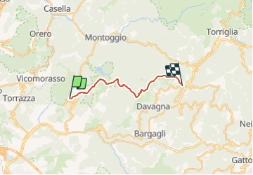
Randonnée A pied de 12,7 km à découvrir à Ligurie, Gênes, Montoggio. Cette randonnée est proposée par SityTrail - itinéraires balisés pédestres.
Description
Randonnée créée par Club Alpino Italiano.
Sentiero Italia CAI 2019
Symbole: AV on white red flag
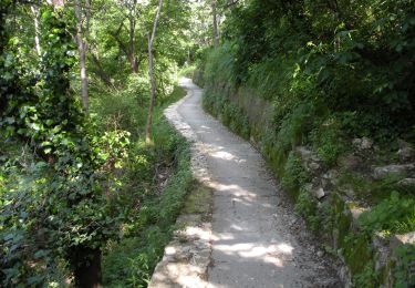
Localisation
Pays :
Italie
Région :
Ligurie
Département/Province :
Gênes
Commune :
Montoggio
Localité :
Unknown
Départ:(Dec)
Départ:(UTM)
500716 ; 4924318 (32T) N.
Commentaires
Randonnées à proximité
![Randonnée A pied Gênes - Sant'Eusebio - Forte Ratti - Photo](https://media.geolcdn.com/t/375/260/f6d10e63-6774-496a-8a16-7d3e345eccf9.jpeg&format=jpg&maxdim=2)
![A pied A pied](https://static1.geolcdn.com/sitytour/trail-icons/100.png)
Sant'Eusebio - Forte Ratti
A pied
Facile
Gênes,
Ligurie,
Gênes,
Italie
![](/images/other/stat-length.png)
5,8 km | 9,7 km-effort
2h 12min
![](https://static1.geolcdn.com/siteimages/upload/files/16400158638029165_repeat_loop_refresh_sync_direction_icon.png)
Non
![Randonnée A pied Gênes - Anello Acquedotto Storico di Genova (AQ2) - Photo](https://media.geolcdn.com/t/375/260/a887bd75-244a-467e-9462-1cfecd6d3fef.jpeg&format=jpg&maxdim=2)
![A pied A pied](https://static1.geolcdn.com/sitytour/trail-icons/100.png)
Anello Acquedotto Storico di Genova (AQ2)
A pied
Facile
Gênes,
Ligurie,
Gênes,
Italie
![](/images/other/stat-length.png)
5,3 km | 7,4 km-effort
1h 41min
![](https://static1.geolcdn.com/siteimages/upload/files/16400158638029165_repeat_loop_refresh_sync_direction_icon.png)
Non
![Randonnée A pied Gênes - Prato - Cavassolo - Capenardo - Monte Candelozzo - Photo](https://media.geolcdn.com/t/375/260/1fb3f7cf-8100-4756-9e75-61717219557a.jpeg&format=jpg&maxdim=2)
![A pied A pied](https://static1.geolcdn.com/sitytour/trail-icons/100.png)
Prato - Cavassolo - Capenardo - Monte Candelozzo
A pied
Facile
Gênes,
Ligurie,
Gênes,
Italie
![](/images/other/stat-length.png)
8,1 km | 18,1 km-effort
4h 7min
![](https://static1.geolcdn.com/siteimages/upload/files/16400158638029165_repeat_loop_refresh_sync_direction_icon.png)
Non
![Randonnée A pied Gênes - San Sebastiano - Sella del Diamante - Bolzaneto - Photo](https://media.geolcdn.com/t/375/260/3a4d3fc0-20ab-4089-bfe0-0a8eff5432c2.jpeg&format=jpg&maxdim=2)
![A pied A pied](https://static1.geolcdn.com/sitytour/trail-icons/100.png)
San Sebastiano - Sella del Diamante - Bolzaneto
A pied
Facile
Gênes,
Ligurie,
Gênes,
Italie
![](/images/other/stat-length.png)
10,1 km | 17,3 km-effort
3h 55min
![](https://static1.geolcdn.com/siteimages/upload/files/16400158638029165_repeat_loop_refresh_sync_direction_icon.png)
Non
![Randonnée A pied Gênes - San Gottardo - Forte Diamante (AQ1) - Photo](https://media.geolcdn.com/t/375/260/d9db7dff-6f9c-4f80-afaf-cd1d1e51e81d.jpeg&format=jpg&maxdim=2)
![A pied A pied](https://static1.geolcdn.com/sitytour/trail-icons/100.png)
San Gottardo - Forte Diamante (AQ1)
A pied
Facile
Gênes,
Ligurie,
Gênes,
Italie
![](/images/other/stat-length.png)
3,9 km | 9,1 km-effort
2h 4min
![](https://static1.geolcdn.com/siteimages/upload/files/16400158638029165_repeat_loop_refresh_sync_direction_icon.png)
Non
![Randonnée A pied Montoggio - Allacciamento Sella-Avosso - Photo](https://media.geolcdn.com/t/375/260/6c24fc41-2fc4-47e9-86b5-e9dfd74062b7.jpeg&format=jpg&maxdim=2)
![A pied A pied](https://static1.geolcdn.com/sitytour/trail-icons/100.png)
Allacciamento Sella-Avosso
A pied
Facile
Montoggio,
Ligurie,
Gênes,
Italie
![](/images/other/stat-length.png)
3,6 km | 5,6 km-effort
1h 16min
![](https://static1.geolcdn.com/siteimages/upload/files/16400158638029165_repeat_loop_refresh_sync_direction_icon.png)
Non
![Randonnée A pied Davagna - Prato- Canate di Marsiglia - Capenardo - Photo](https://media.geolcdn.com/t/375/260/8dbeab8e-b58f-4884-a1f3-c719060e84a0.jpeg&format=jpg&maxdim=2)
![A pied A pied](https://static1.geolcdn.com/sitytour/trail-icons/100.png)
Prato- Canate di Marsiglia - Capenardo
A pied
Facile
Davagna,
Ligurie,
Gênes,
Italie
![](/images/other/stat-length.png)
7,5 km | 11,4 km-effort
2h 36min
![](https://static1.geolcdn.com/siteimages/upload/files/16400158638029165_repeat_loop_refresh_sync_direction_icon.png)
Non
![Randonnée A pied Gênes - Prato - Gola di Sisa - Tre Fontane - Photo](https://media.geolcdn.com/t/375/260/82a639f8-da90-48bc-a7e4-79a6bdafa6a8.jpeg&format=jpg&maxdim=2)
![A pied A pied](https://static1.geolcdn.com/sitytour/trail-icons/100.png)
Prato - Gola di Sisa - Tre Fontane
A pied
Facile
Gênes,
Ligurie,
Gênes,
Italie
![](/images/other/stat-length.png)
9,1 km | 16,7 km-effort
3h 47min
![](https://static1.geolcdn.com/siteimages/upload/files/16400158638029165_repeat_loop_refresh_sync_direction_icon.png)
Non
![Randonnée A pied Montoggio - Crocera di Pino - Creto - Photo](https://media.geolcdn.com/t/375/260/800b696b-0784-428f-98e3-4aabfbee4b57.jpeg&format=jpg&maxdim=2)
![A pied A pied](https://static1.geolcdn.com/sitytour/trail-icons/100.png)
Crocera di Pino - Creto
A pied
Facile
Montoggio,
Ligurie,
Gênes,
Italie
![](/images/other/stat-length.png)
6,4 km | 8,6 km-effort
1h 56min
![](https://static1.geolcdn.com/siteimages/upload/files/16400158638029165_repeat_loop_refresh_sync_direction_icon.png)
Non