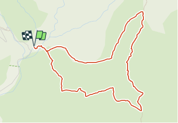
![](/images/other/stat-length.png)
![Randonnée A pied Rabós - Sant Quirze de Colera, per la cresta i les carenes - Photo](https://media.geolcdn.com/t/1900/400/23edd425-a1a1-479d-bd13-d1cfe66918e4.jpeg&format=pjpeg&maxdim=2)
Sant Quirze de Colera, per la cresta i les carenes
SityTrail - itinéraires balisés pédestres
Tous les sentiers balisés d’Europe GUIDE+
![Longueur](/images/other/stat-length.png)
![Altitude max](https://static1.geolcdn.com/siteimages/upload/files/1508320355ic_sort_altitude_max_24dp.png)
![Dénivelé positif](https://static1.geolcdn.com/siteimages/upload/files/1508320355ic_sort_den_pos_24dp.png)
![Km-Effort](/images/other/stat-length.png)
![Altitude min](https://static1.geolcdn.com/siteimages/upload/files/1508320355ic_sort_altitude_min_24dp.png)
![Dénivelé négatif](https://static1.geolcdn.com/siteimages/upload/files/1508320355ic_sort_den_neg_24dp.png)
![Boucle](https://static1.geolcdn.com/siteimages/upload/files/16400158638029165_repeat_loop_refresh_sync_direction_icon.png)
![A pied](https://static1.geolcdn.com/sitytour/trail-icons/100.png)
2h40
Difficulté : Facile
![Scannez ce code QR pour ouvrir la randonnée dans l'application SityTrail](https://capi.geolives.com/qq0zvz2zws4bq2lad0pu/sitytour/trails/3110671/qr.png?size=200)
Application GPS de randonnée GRATUITE
À propos
Randonnée A pied de 6,4 km à découvrir à Catalogne, Gérone, Rabós. Cette randonnée est proposée par SityTrail - itinéraires balisés pédestres.
Description
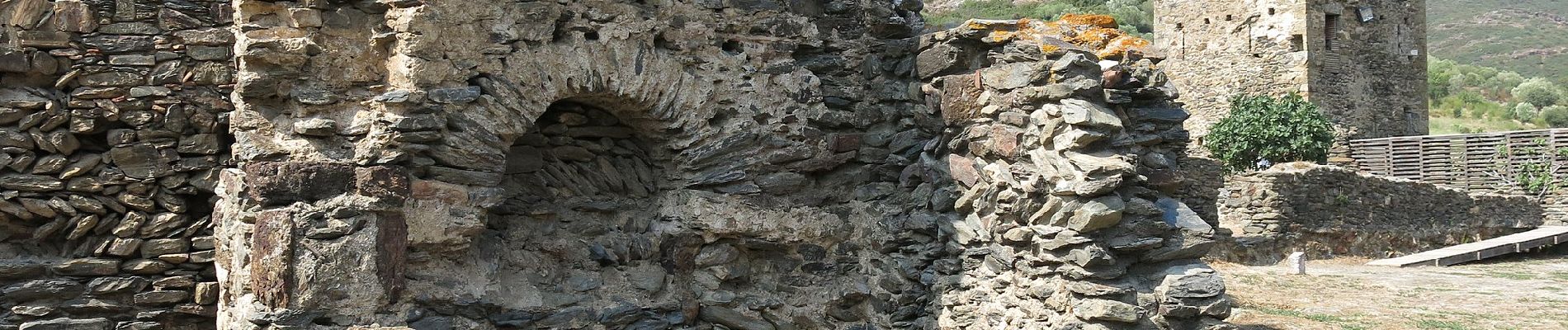
Breu introducció. Ruta circular que transcorre íntegrament pels voltants de l´antic monestir de Sant Quirze de Colera, dintre del municipi de Rabós d´Empordà, a la comarca de l´Alt Empordà. Sortida que es pot plantejar com a una matinal, donat que no arriba a les tres hores de durada. Podem complementar-la amb una visita al proper…
Site web: https://senderismegirona.org/2015/01/18/sant-quirze-de-colera-ruta-per-la-carena-i-les-crestes/
Localisation
Commentaires
Randonnées à proximité
![Randonnée Autre activité Banyuls-sur-Mer - banyuls - Photo](https://media.geolcdn.com/t/375/260/ext.jpg?maxdim=2&url=https%3A%2F%2Fstatic1.geolcdn.com%2Fsiteimages%2Fupload%2Ffiles%2F1545311037marcheuse_200dpi.jpg)
![Autre activité Autre activité](https://static1.geolcdn.com/sitytour/trail-icons/900.png)
Autre activité
![](/images/other/stat-length.png)
![](https://static1.geolcdn.com/siteimages/upload/files/16400158638029165_repeat_loop_refresh_sync_direction_icon.png)
![Randonnée Marche Banyuls-sur-Mer - 20220427 col de Banyuls-Sant Quirze de Colera - Photo](https://media.geolcdn.com/t/375/260/06048fb9-1a7e-4206-b6a1-f8c502218865.jpg&format=jpg&maxdim=2)
![Marche Marche](https://static1.geolcdn.com/sitytour/trail-icons/101.png)
Marche
![](/images/other/stat-length.png)
![](https://static1.geolcdn.com/siteimages/upload/files/16400158638029165_repeat_loop_refresh_sync_direction_icon.png)
![Randonnée A pied Banyuls-sur-Mer - Sentier de la Liberté - Photo](https://media.geolcdn.com/t/375/260/e8791471-c82e-4f49-9ca6-3173817ff428.jpeg&format=jpg&maxdim=2)
![A pied A pied](https://static1.geolcdn.com/sitytour/trail-icons/100.png)
A pied
![](/images/other/stat-length.png)
![](https://static1.geolcdn.com/siteimages/upload/files/16400158638029165_repeat_loop_refresh_sync_direction_icon.png)
![Randonnée Marche Espolla - Saint génis d’Espract - Photo](https://media.geolcdn.com/t/375/260/bf0fd629-10b1-4873-b704-8d6c98a45412.jpg&format=jpg&maxdim=2)
![Marche Marche](https://static1.geolcdn.com/sitytour/trail-icons/101.png)
Marche
![](/images/other/stat-length.png)
![](https://static1.geolcdn.com/siteimages/upload/files/16400158638029165_repeat_loop_refresh_sync_direction_icon.png)
![Randonnée Marche Banyuls-sur-Mer - Col Banuyls - Photo](https://media.geolcdn.com/t/375/260/5e18f59c-3b94-4fec-bdd5-bafec29a1191.jpg&format=jpg&maxdim=2)
![Marche Marche](https://static1.geolcdn.com/sitytour/trail-icons/101.png)
Marche
![](/images/other/stat-length.png)
![](https://static1.geolcdn.com/siteimages/upload/files/16400158638029165_repeat_loop_refresh_sync_direction_icon.png)
![Randonnée Marche Rabós - Rabos effacer surplus…. - Photo](https://media.geolcdn.com/t/375/260/67d2c549-b679-4bf5-88f9-d23334e4a7a8.jpg&format=jpg&maxdim=2)
![Marche Marche](https://static1.geolcdn.com/sitytour/trail-icons/101.png)
Marche
![](/images/other/stat-length.png)
![](https://static1.geolcdn.com/siteimages/upload/files/16400158638029165_repeat_loop_refresh_sync_direction_icon.png)
![Randonnée Marche Llançà - Vilamaniscle san Sylvestre - Photo](https://media.geolcdn.com/t/375/260/4ac8b5c0-c4d3-4bc4-9437-ac8a40463100.jpg&format=jpg&maxdim=2)
![Marche Marche](https://static1.geolcdn.com/sitytour/trail-icons/101.png)
Marche
![](/images/other/stat-length.png)
![](https://static1.geolcdn.com/siteimages/upload/files/16400158638029165_repeat_loop_refresh_sync_direction_icon.png)
![Randonnée Marche Colera - San Miquel de colera - Photo](https://media.geolcdn.com/t/375/260/f7c667e4-be50-461a-94fa-4995b3de2067.jpg&format=jpg&maxdim=2)
![Marche Marche](https://static1.geolcdn.com/sitytour/trail-icons/101.png)
Marche
![](/images/other/stat-length.png)
![](https://static1.geolcdn.com/siteimages/upload/files/16400158638029165_repeat_loop_refresh_sync_direction_icon.png)
![Randonnée Marche Banyuls-sur-Mer - Randonnée sur les Crêtes de Banyuls - Photo](https://media.geolcdn.com/t/375/260/ext.jpg?maxdim=2&url=https%3A%2F%2Fstatic1.geolcdn.com%2Fsiteimages%2Fupload%2Ffiles%2F1553511878bg_sport_marche.png)
![Marche Marche](https://static1.geolcdn.com/sitytour/trail-icons/101.png)
Marche
![](/images/other/stat-length.png)
![](https://static1.geolcdn.com/siteimages/upload/files/16400158638029165_repeat_loop_refresh_sync_direction_icon.png)