![](/images/other/stat-length.png)
![Randonnée A pied Maià de Montcal - Ruta del romaní - Photo](https://media.geolcdn.com/t/1900/400/2c173b61-e6ce-4bbd-b16b-b8d172bb0f25.jpeg&format=pjpeg&maxdim=2)
Ruta del romaní
SityTrail - itinéraires balisés pédestres
Tous les sentiers balisés d’Europe GUIDE+
![Longueur](/images/other/stat-length.png)
![Altitude max](https://static1.geolcdn.com/siteimages/upload/files/1508320355ic_sort_altitude_max_24dp.png)
![Dénivelé positif](https://static1.geolcdn.com/siteimages/upload/files/1508320355ic_sort_den_pos_24dp.png)
![Km-Effort](/images/other/stat-length.png)
![Altitude min](https://static1.geolcdn.com/siteimages/upload/files/1508320355ic_sort_altitude_min_24dp.png)
![Dénivelé négatif](https://static1.geolcdn.com/siteimages/upload/files/1508320355ic_sort_den_neg_24dp.png)
![Boucle](https://static1.geolcdn.com/siteimages/upload/files/16400158638029165_repeat_loop_refresh_sync_direction_icon.png)
![A pied](https://static1.geolcdn.com/sitytour/trail-icons/100.png)
3h07
Difficulté : Facile
![Scannez ce code QR pour ouvrir la randonnée dans l'application SityTrail](https://capi.geolives.com/qq0zvz2zws4bq2lad0pu/sitytour/trails/3110579/qr.png?size=200)
Application GPS de randonnée GRATUITE
À propos
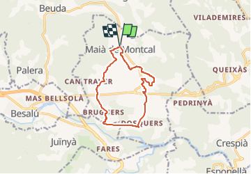
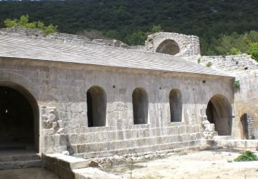
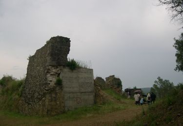
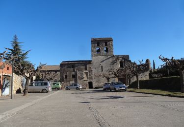
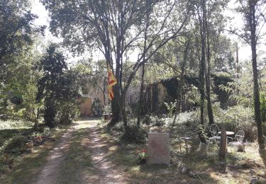
Randonnée A pied de 11,5 km à découvrir à Catalogne, Gérone, Maià de Montcal. Cette randonnée est proposée par SityTrail - itinéraires balisés pédestres.
Description
Aquesta ruta en bicicleta és apta per tota la família i hi descobrireu un paisatge rural entre camps i pairalies
Site web: https://www.itinerannia.net/ca/itineraris/ruta-del-romani-ruta-2-maia-de-montcal/
Localisation
Commentaires
Randonnées à proximité
![Randonnée A pied Crespià - Crespià-Pedrinyà-Sant Miquel de la Roca - Photo](https://media.geolcdn.com/t/375/260/f15c5281-f9ff-44dd-9738-7f66ab74f9cd.jpeg&format=jpg&maxdim=2)
![A pied A pied](https://static1.geolcdn.com/sitytour/trail-icons/100.png)
A pied
![](/images/other/stat-length.png)
![](https://static1.geolcdn.com/siteimages/upload/files/16400158638029165_repeat_loop_refresh_sync_direction_icon.png)
![Randonnée A pied Besalú - Besalú-Beuda - Photo](https://media.geolcdn.com/t/375/260/027c608a-ef9d-47db-8df1-f79bfa409fdd.jpeg&format=jpg&maxdim=2)
![A pied A pied](https://static1.geolcdn.com/sitytour/trail-icons/100.png)
![Randonnée A pied Besalú - Besalú-Dosquers - Photo](https://media.geolcdn.com/t/375/260/d00a477c-6daa-462e-8a73-2684ff091a77.jpeg&format=jpg&maxdim=2)
![A pied A pied](https://static1.geolcdn.com/sitytour/trail-icons/100.png)
A pied
![](/images/other/stat-length.png)
![](https://static1.geolcdn.com/siteimages/upload/files/16400158638029165_repeat_loop_refresh_sync_direction_icon.png)
![Randonnée A pied Beuda - Mitja Marató Mare de Déu del Mont (MdM) - Photo](https://media.geolcdn.com/t/375/260/fd8eaf84-117f-4300-ace9-8441f466d75b.jpeg&format=jpg&maxdim=2)
![A pied A pied](https://static1.geolcdn.com/sitytour/trail-icons/100.png)
A pied
![](/images/other/stat-length.png)
![](https://static1.geolcdn.com/siteimages/upload/files/16400158638029165_repeat_loop_refresh_sync_direction_icon.png)
![Randonnée A pied Besalú - Circuit de Besalú - Photo](https://media.geolcdn.com/t/375/260/027c608a-ef9d-47db-8df1-f79bfa409fdd.jpeg&format=jpg&maxdim=2)
![A pied A pied](https://static1.geolcdn.com/sitytour/trail-icons/100.png)
A pied
![](/images/other/stat-length.png)
![](https://static1.geolcdn.com/siteimages/upload/files/16400158638029165_repeat_loop_refresh_sync_direction_icon.png)
![Randonnée A pied Maià de Montcal - Balcó de la Garrotxa - Photo](https://media.geolcdn.com/t/375/260/727141d5-2c9d-48b1-8444-e50cc7feda29.jpeg&format=jpg&maxdim=2)
![A pied A pied](https://static1.geolcdn.com/sitytour/trail-icons/100.png)
A pied
![](/images/other/stat-length.png)
![](https://static1.geolcdn.com/siteimages/upload/files/16400158638029165_repeat_loop_refresh_sync_direction_icon.png)
![Randonnée A pied Esponellà - Ruta pels volts d’Esponellà - Photo](https://media.geolcdn.com/t/375/260/1eea8c8a-9ac9-4eb8-b532-6f00f86e97fd.jpeg&format=jpg&maxdim=2)
![A pied A pied](https://static1.geolcdn.com/sitytour/trail-icons/100.png)
A pied
![](/images/other/stat-length.png)
![](https://static1.geolcdn.com/siteimages/upload/files/16400158638029165_repeat_loop_refresh_sync_direction_icon.png)
![Randonnée A pied Crespià - Ruta de la Font - Photo](https://media.geolcdn.com/t/375/260/b833bb1d-ec48-4995-bc7a-522ef4644659.jpeg&format=jpg&maxdim=2)
![A pied A pied](https://static1.geolcdn.com/sitytour/trail-icons/100.png)
A pied
![](/images/other/stat-length.png)
![](https://static1.geolcdn.com/siteimages/upload/files/16400158638029165_repeat_loop_refresh_sync_direction_icon.png)
![Randonnée A pied Esponellà - Volta pel Pla de Martís - Photo](https://media.geolcdn.com/t/375/260/5a59407e-ebc3-4238-b6df-8ca405ca84c0.jpeg&format=jpg&maxdim=2)
![A pied A pied](https://static1.geolcdn.com/sitytour/trail-icons/100.png)
A pied
![](/images/other/stat-length.png)
![](https://static1.geolcdn.com/siteimages/upload/files/16400158638029165_repeat_loop_refresh_sync_direction_icon.png)