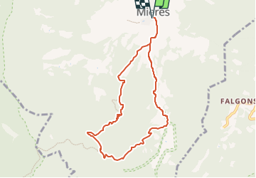
![](/images/other/stat-length.png)
![Randonnée A pied Mieres - Ruta dels carboners. Mieres - Photo](https://media.geolcdn.com/t/1900/400/290ea93a-3def-4142-b339-4b864a71c8d5.jpeg&format=pjpeg&maxdim=2)
Ruta dels carboners. Mieres
SityTrail - itinéraires balisés pédestres
Tous les sentiers balisés d’Europe GUIDE+
![Longueur](/images/other/stat-length.png)
![Altitude max](https://static1.geolcdn.com/siteimages/upload/files/1508320355ic_sort_altitude_max_24dp.png)
![Dénivelé positif](https://static1.geolcdn.com/siteimages/upload/files/1508320355ic_sort_den_pos_24dp.png)
![Km-Effort](/images/other/stat-length.png)
![Altitude min](https://static1.geolcdn.com/siteimages/upload/files/1508320355ic_sort_altitude_min_24dp.png)
![Dénivelé négatif](https://static1.geolcdn.com/siteimages/upload/files/1508320355ic_sort_den_neg_24dp.png)
![Boucle](https://static1.geolcdn.com/siteimages/upload/files/16400158638029165_repeat_loop_refresh_sync_direction_icon.png)
![A pied](https://static1.geolcdn.com/sitytour/trail-icons/100.png)
3h06
Difficulté : Facile
![Scannez ce code QR pour ouvrir la randonnée dans l'application SityTrail](https://capi.geolives.com/qq0zvz2zws4bq2lad0pu/sitytour/trails/3110540/qr.png?size=200)
Application GPS de randonnée GRATUITE
À propos
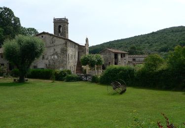
Randonnée A pied de 8,6 km à découvrir à Catalogne, Gérone, Mieres. Cette randonnée est proposée par SityTrail - itinéraires balisés pédestres.
Description
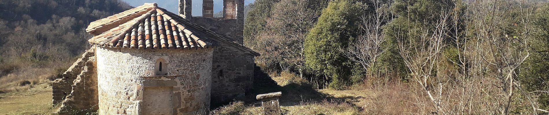
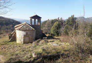
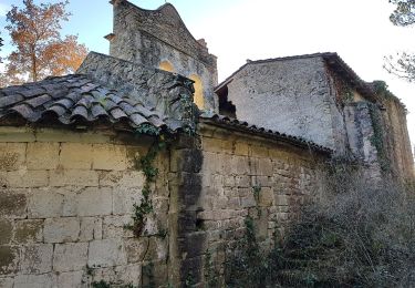
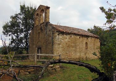
Aquest itinerari recupera camins usats per baixar el carbó de la serra de Finestres: el que passava per la casa de Font Ricard, un bonic camí de matxo que enllaça el veïnat de Ruïtlles amb l’ermita del Freixe i el camí de les Marrades
Site web: https://www.itinerannia.net/ca/itineraris/ruta-dels-carboners-ruta-2-mieres/
Localisation
Commentaires
Randonnées à proximité
![Randonnée A pied Sant Ferriol - El Santuari del Collell: Presó de Guerra - Photo](https://media.geolcdn.com/t/375/260/d99155fb-0b90-41f2-88f0-967efb98deaf.jpeg&format=jpg&maxdim=2)
![A pied A pied](https://static1.geolcdn.com/sitytour/trail-icons/100.png)
A pied
![](/images/other/stat-length.png)
![](https://static1.geolcdn.com/siteimages/upload/files/16400158638029165_repeat_loop_refresh_sync_direction_icon.png)
![Randonnée A pied Mieres - Ruta dels carboners i el bac - Photo](https://media.geolcdn.com/t/375/260/290ea93a-3def-4142-b339-4b864a71c8d5.jpeg&format=jpg&maxdim=2)
![A pied A pied](https://static1.geolcdn.com/sitytour/trail-icons/100.png)
A pied
![](/images/other/stat-length.png)
![](https://static1.geolcdn.com/siteimages/upload/files/16400158638029165_repeat_loop_refresh_sync_direction_icon.png)
![Randonnée A pied Mieres - El Balcó de Mieres - Photo](https://media.geolcdn.com/t/375/260/290ea93a-3def-4142-b339-4b864a71c8d5.jpeg&format=jpg&maxdim=2)
![A pied A pied](https://static1.geolcdn.com/sitytour/trail-icons/100.png)
A pied
![](/images/other/stat-length.png)
![](https://static1.geolcdn.com/siteimages/upload/files/16400158638029165_repeat_loop_refresh_sync_direction_icon.png)
![Randonnée A pied Sant Miquel de Campmajor - Ruta del veïnat de Roca i Briolf - Photo](https://media.geolcdn.com/t/375/260/ed1b8fda-1021-494f-a063-91a6cfa060a2.jpeg&format=jpg&maxdim=2)
![A pied A pied](https://static1.geolcdn.com/sitytour/trail-icons/100.png)
A pied
![](/images/other/stat-length.png)
![](https://static1.geolcdn.com/siteimages/upload/files/16400158638029165_repeat_loop_refresh_sync_direction_icon.png)
![Randonnée A pied Sant Aniol de Finestres - Finestres-Sant Aniol pel coll de Palomera - Photo](https://media.geolcdn.com/t/375/260/22fe7fa2-68fb-4d87-b3c5-e05cc3b80534.jpeg&format=jpg&maxdim=2)
![A pied A pied](https://static1.geolcdn.com/sitytour/trail-icons/100.png)
A pied
![](/images/other/stat-length.png)
![](https://static1.geolcdn.com/siteimages/upload/files/16400158638029165_repeat_loop_refresh_sync_direction_icon.png)
![Randonnée A pied Sant Miquel de Campmajor - El Refugi dels emboscats - Photo](https://media.geolcdn.com/t/375/260/ext.jpg?maxdim=2&url=https%3A%2F%2Fstatic1.geolcdn.com%2Fsiteimages%2Fupload%2Ffiles%2F1545311037marcheuse_200dpi.jpg)
![A pied A pied](https://static1.geolcdn.com/sitytour/trail-icons/100.png)
A pied
![](/images/other/stat-length.png)
![](https://static1.geolcdn.com/siteimages/upload/files/16400158638029165_repeat_loop_refresh_sync_direction_icon.png)