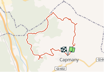
![](/images/other/stat-length.png)
![Randonnée A pied Capmany - Itinerari megalític de Campmany - Photo](https://media.geolcdn.com/t/1900/400/869eddc9-99f0-4850-9d15-c9f49ca84b69.jpeg&format=pjpeg&maxdim=2)
Itinerari megalític de Campmany
SityTrail - itinéraires balisés pédestres
Tous les sentiers balisés d’Europe GUIDE+
![Longueur](/images/other/stat-length.png)
![Altitude max](https://static1.geolcdn.com/siteimages/upload/files/1508320355ic_sort_altitude_max_24dp.png)
![Dénivelé positif](https://static1.geolcdn.com/siteimages/upload/files/1508320355ic_sort_den_pos_24dp.png)
![Km-Effort](/images/other/stat-length.png)
![Altitude min](https://static1.geolcdn.com/siteimages/upload/files/1508320355ic_sort_altitude_min_24dp.png)
![Dénivelé négatif](https://static1.geolcdn.com/siteimages/upload/files/1508320355ic_sort_den_neg_24dp.png)
![Boucle](https://static1.geolcdn.com/siteimages/upload/files/16400158638029165_repeat_loop_refresh_sync_direction_icon.png)
![A pied](https://static1.geolcdn.com/sitytour/trail-icons/100.png)
2h51
Difficulté : Facile
![Scannez ce code QR pour ouvrir la randonnée dans l'application SityTrail](https://capi.geolives.com/qq0zvz2zws4bq2lad0pu/sitytour/trails/3110488/qr.png?size=200)
Application GPS de randonnée GRATUITE
À propos
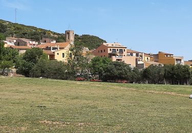
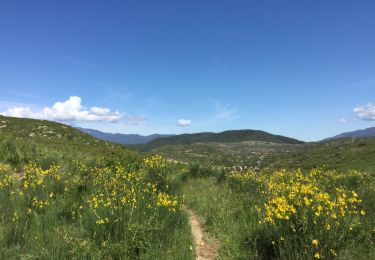
Randonnée A pied de 10,5 km à découvrir à Catalogne, Gérone, Capmany. Cette randonnée est proposée par SityTrail - itinéraires balisés pédestres.
Description
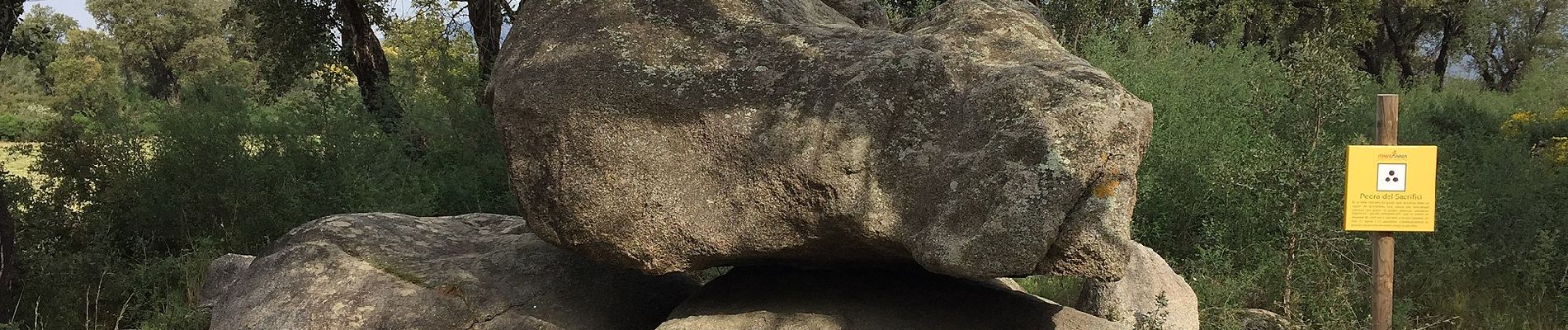
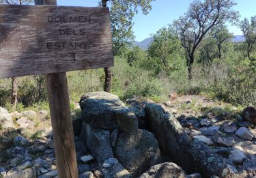
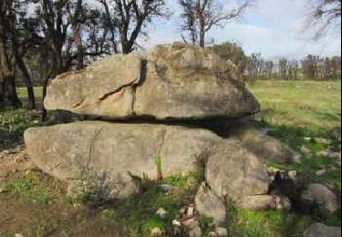
Aquest és un itinerari que tan es pot fer a peu com en bicicleta, trobareu les fletxes verticals d’Itinerànnia i al llarg del camí les marques de pintura groga.
Site web: https://www.itinerannia.net/ca/itineraris/itinerari-megalitic-de-capmany-ruta-13-alt-emporda/
Localisation
Commentaires
Randonnées à proximité
![Randonnée A pied la Jonquera - Marxa dels dòlmens i ruta dels estanys - Photo](https://media.geolcdn.com/t/375/260/fedcbff4-20db-4413-b792-cfa0f34dafa2.jpeg&format=jpg&maxdim=2)
![A pied A pied](https://static1.geolcdn.com/sitytour/trail-icons/100.png)
A pied
![](/images/other/stat-length.png)
![](https://static1.geolcdn.com/siteimages/upload/files/16400158638029165_repeat_loop_refresh_sync_direction_icon.png)
![Randonnée A pied la Jonquera - PR-C 71 La Jonquera-Portbou - Photo](https://media.geolcdn.com/t/375/260/5e6d3380-2250-4b33-97db-8f0c01794288.jpeg&format=jpg&maxdim=2)
![A pied A pied](https://static1.geolcdn.com/sitytour/trail-icons/100.png)
A pied
![](/images/other/stat-length.png)
![](https://static1.geolcdn.com/siteimages/upload/files/16400158638029165_repeat_loop_refresh_sync_direction_icon.png)
![Randonnée Marche la Jonquera - CIRCUIT DES MÉGALITHES depuis EL FOGON - Photo](https://media.geolcdn.com/t/375/260/7a6e5bb6-23f5-4b50-857a-537a11402d8b.jpg&format=jpg&maxdim=2)
![Marche Marche](https://static1.geolcdn.com/sitytour/trail-icons/101.png)
Marche
![](/images/other/stat-length.png)
![](https://static1.geolcdn.com/siteimages/upload/files/16400158638029165_repeat_loop_refresh_sync_direction_icon.png)
![Randonnée Marche Biure - biure - Photo](https://media.geolcdn.com/t/375/260/406f6110-5921-4658-87fd-9b6ed94eb606.jpg&format=jpg&maxdim=2)
![Marche Marche](https://static1.geolcdn.com/sitytour/trail-icons/101.png)
![Randonnée Marche la Jonquera - 20230112 Site mégalithique- château Requesens - Photo](https://media.geolcdn.com/t/375/260/434ae223-eff4-4144-bd74-a07ff9e915d6.jpg&format=jpg&maxdim=2)
![Marche Marche](https://static1.geolcdn.com/sitytour/trail-icons/101.png)
Marche
![](/images/other/stat-length.png)
![](https://static1.geolcdn.com/siteimages/upload/files/16400158638029165_repeat_loop_refresh_sync_direction_icon.png)
![Randonnée Marche Biure - bourse. castel de mont roigt / retour par ma vallée - Photo](https://media.geolcdn.com/t/375/260/12822935-2085-41cc-b0ab-a826223bff2b.jpg&format=jpg&maxdim=2)
![Marche Marche](https://static1.geolcdn.com/sitytour/trail-icons/101.png)
Marche
![](/images/other/stat-length.png)
![](https://static1.geolcdn.com/siteimages/upload/files/16400158638029165_repeat_loop_refresh_sync_direction_icon.png)
![Randonnée Marche Biure - autour Biure Escaules Boadea - Photo](https://media.geolcdn.com/t/375/260/ext.jpg?maxdim=2&url=https%3A%2F%2Fservices.sitytrail.com%2FGeolivesWS%2FDownloadMedia.ashx%3FTrailID%3D1140198%26Media%3D20180608142255.jpg)
![Marche Marche](https://static1.geolcdn.com/sitytour/trail-icons/101.png)
Marche
![](/images/other/stat-length.png)
![](https://static1.geolcdn.com/siteimages/upload/files/16400158638029165_repeat_loop_refresh_sync_direction_icon.png)
![Randonnée Marche Biure - autour Biure Escaules Boadea - Photo](https://media.geolcdn.com/t/375/260/ext.jpg?maxdim=2&url=https%3A%2F%2Fservices.sitytrail.com%2FGeolivesWS%2FDownloadMedia.ashx%3FTrailID%3D982697%26Media%3D20180608112402.jpg)
![Marche Marche](https://static1.geolcdn.com/sitytour/trail-icons/101.png)
Marche
![](/images/other/stat-length.png)
![](https://static1.geolcdn.com/siteimages/upload/files/16400158638029165_repeat_loop_refresh_sync_direction_icon.png)
![Randonnée Marche Capmany - Capmany Mégalithique_2 - Photo](https://media.geolcdn.com/t/375/260/ext.jpg?maxdim=2&url=https%3A%2F%2Fservices.sitytrail.com%2FGeolivesWS%2FDownloadMedia.ashx%3FTrailID%3D304677%26Media%3D70129613-bd6d-4e80-a4c3-608884f2ea29.jpeg)
![Marche Marche](https://static1.geolcdn.com/sitytour/trail-icons/101.png)
Marche
![](/images/other/stat-length.png)
![](https://static1.geolcdn.com/siteimages/upload/files/16400158638029165_repeat_loop_refresh_sync_direction_icon.png)