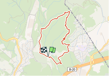
![](/images/other/stat-length.png)
![Randonnée A pied Badalona - SL-C 140La Vall de Pomar - Photo](https://media.geolcdn.com/t/1900/400/ext.pjpeg?maxdim=2&url=https%3A%2F%2Fstatic1.geolcdn.com%2Fsiteimages%2Fupload%2Ffiles%2F1545311037marcheuse_200dpi.jpg)
SL-C 140La Vall de Pomar
SityTrail - itinéraires balisés pédestres
Tous les sentiers balisés d’Europe GUIDE+
![Longueur](/images/other/stat-length.png)
![Altitude max](https://static1.geolcdn.com/siteimages/upload/files/1508320355ic_sort_altitude_max_24dp.png)
![Dénivelé positif](https://static1.geolcdn.com/siteimages/upload/files/1508320355ic_sort_den_pos_24dp.png)
![Km-Effort](/images/other/stat-length.png)
![Altitude min](https://static1.geolcdn.com/siteimages/upload/files/1508320355ic_sort_altitude_min_24dp.png)
![Dénivelé négatif](https://static1.geolcdn.com/siteimages/upload/files/1508320355ic_sort_den_neg_24dp.png)
![Boucle](https://static1.geolcdn.com/siteimages/upload/files/16400158638029165_repeat_loop_refresh_sync_direction_icon.png)
![A pied](https://static1.geolcdn.com/sitytour/trail-icons/100.png)
1h35
Difficulté : Facile
![Scannez ce code QR pour ouvrir la randonnée dans l'application SityTrail](https://capi.geolives.com/qq0zvz2zws4bq2lad0pu/sitytour/trails/3110466/qr.png?size=200)
Application GPS de randonnée GRATUITE
À propos
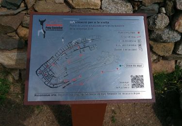
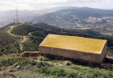
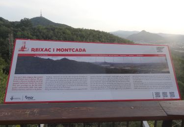
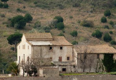
Randonnée A pied de 4,1 km à découvrir à Catalogne, Barcelone, Badalona. Cette randonnée est proposée par SityTrail - itinéraires balisés pédestres.
Description
Randonnée créée par Diputació de Barcelona.
Symbole: green:white:green_lower:140:black
Site web: https://view.gooltracking.com/dibaparcs/routes/view/sl-c-140-la-vall-de-pomar
Localisation
Commentaires
Randonnées à proximité
![Randonnée A pied Tiana - SL-C 95 Tiana-Turó d'en Galzeran - Photo](https://media.geolcdn.com/t/375/260/7693545e-e8e8-4b85-873d-7dd58ac6068c.jpeg&format=jpg&maxdim=2)
![A pied A pied](https://static1.geolcdn.com/sitytour/trail-icons/100.png)
A pied
![](/images/other/stat-length.png)
![](https://static1.geolcdn.com/siteimages/upload/files/16400158638029165_repeat_loop_refresh_sync_direction_icon.png)
![Randonnée A pied Santa Coloma de Gramenet - Torrent de les Bruixes. Itinerari pedagògic - Photo](https://media.geolcdn.com/t/375/260/a2bc860f-efc2-4134-858b-aebc0b61df51.jpeg&format=jpg&maxdim=2)
![A pied A pied](https://static1.geolcdn.com/sitytour/trail-icons/100.png)
A pied
![](/images/other/stat-length.png)
![](https://static1.geolcdn.com/siteimages/upload/files/16400158638029165_repeat_loop_refresh_sync_direction_icon.png)
![Randonnée A pied Santa Coloma de Gramenet - SL-C 147 De la font de l'Alzina al Puig Castellar - Photo](https://media.geolcdn.com/t/375/260/b5c4eca4-138c-4406-87d9-ab331c1a89a0.jpeg&format=jpg&maxdim=2)
![A pied A pied](https://static1.geolcdn.com/sitytour/trail-icons/100.png)
A pied
![](/images/other/stat-length.png)
![](https://static1.geolcdn.com/siteimages/upload/files/16400158638029165_repeat_loop_refresh_sync_direction_icon.png)
![Randonnée A pied Santa Coloma de Gramenet - SL-C 141 De Torribera al Puig Castellar - Photo](https://media.geolcdn.com/t/375/260/c7e71557-4932-4ab5-8916-73e88aa4e1b8.jpeg&format=jpg&maxdim=2)
![A pied A pied](https://static1.geolcdn.com/sitytour/trail-icons/100.png)
A pied
![](/images/other/stat-length.png)
![](https://static1.geolcdn.com/siteimages/upload/files/16400158638029165_repeat_loop_refresh_sync_direction_icon.png)
![Randonnée A pied Badalona - SL-C 144 La vall de Sant Jeroni de la Murtra - Photo](https://media.geolcdn.com/t/375/260/8d251fbe-802d-4328-9a07-94f0a86b1015.jpeg&format=jpg&maxdim=2)
![A pied A pied](https://static1.geolcdn.com/sitytour/trail-icons/100.png)
A pied
![](/images/other/stat-length.png)
![](https://static1.geolcdn.com/siteimages/upload/files/16400158638029165_repeat_loop_refresh_sync_direction_icon.png)
![Randonnée A pied Montcada i Reixac - SL-C 149 De Sant Pere de Reixac al turó de les Maleses - Photo](https://media.geolcdn.com/t/375/260/2a923eb8-4cdd-47ae-9231-d5cde833c5fc.jpeg&format=jpg&maxdim=2)
![A pied A pied](https://static1.geolcdn.com/sitytour/trail-icons/100.png)
A pied
![](/images/other/stat-length.png)
![](https://static1.geolcdn.com/siteimages/upload/files/16400158638029165_repeat_loop_refresh_sync_direction_icon.png)
![Randonnée A pied Montcada i Reixac - SL-C 143 Al voltant de Sant Pere de Reixac - Photo](https://media.geolcdn.com/t/375/260/d9691ec5-c1cb-404f-8f31-1a6c39028516.jpeg&format=jpg&maxdim=2)
![A pied A pied](https://static1.geolcdn.com/sitytour/trail-icons/100.png)
A pied
![](/images/other/stat-length.png)
![](https://static1.geolcdn.com/siteimages/upload/files/16400158638029165_repeat_loop_refresh_sync_direction_icon.png)
![Randonnée A pied Tiana - SL-C 145 La vall de Montealegre - Photo](https://media.geolcdn.com/t/375/260/f88ab33e-0ff2-472c-a939-c9c8f15287a5.jpeg&format=jpg&maxdim=2)
![A pied A pied](https://static1.geolcdn.com/sitytour/trail-icons/100.png)
A pied
![](/images/other/stat-length.png)
![](https://static1.geolcdn.com/siteimages/upload/files/16400158638029165_repeat_loop_refresh_sync_direction_icon.png)
![Randonnée A pied Sant Fost de Campsentelles - SL-C 150 De la Conreria al turó de les Maleses - Photo](https://media.geolcdn.com/t/375/260/e17d78cd-c3dc-4e04-9a76-c04fa18277fb.jpeg&format=jpg&maxdim=2)
![A pied A pied](https://static1.geolcdn.com/sitytour/trail-icons/100.png)
A pied
![](/images/other/stat-length.png)
![](https://static1.geolcdn.com/siteimages/upload/files/16400158638029165_repeat_loop_refresh_sync_direction_icon.png)