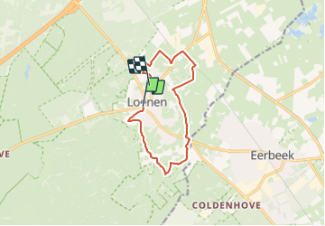
![](/images/other/stat-length.png)
![Randonnée A pied Apeldoorn - Loenense Enkenpad - Photo](https://media.geolcdn.com/t/1900/400/3c5b25f2-3fcc-4c0f-8b21-7f158c919cab.jpeg&format=pjpeg&maxdim=2)
Loenense Enkenpad
SityTrail - itinéraires balisés pédestres
Tous les sentiers balisés d’Europe GUIDE+
![Longueur](/images/other/stat-length.png)
![Altitude max](https://static1.geolcdn.com/siteimages/upload/files/1508320355ic_sort_altitude_max_24dp.png)
![Dénivelé positif](https://static1.geolcdn.com/siteimages/upload/files/1508320355ic_sort_den_pos_24dp.png)
![Km-Effort](/images/other/stat-length.png)
![Altitude min](https://static1.geolcdn.com/siteimages/upload/files/1508320355ic_sort_altitude_min_24dp.png)
![Dénivelé négatif](https://static1.geolcdn.com/siteimages/upload/files/1508320355ic_sort_den_neg_24dp.png)
![Boucle](https://static1.geolcdn.com/siteimages/upload/files/16400158638029165_repeat_loop_refresh_sync_direction_icon.png)
![A pied](https://static1.geolcdn.com/sitytour/trail-icons/100.png)
2h24
Difficulté : Facile
![Scannez ce code QR pour ouvrir la randonnée dans l'application SityTrail](https://capi.geolives.com/qq0zvz2zws4bq2lad0pu/sitytour/trails/3110399/qr.png?size=200)
Application GPS de randonnée GRATUITE
À propos
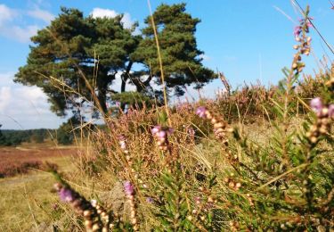
Randonnée A pied de 9,3 km à découvrir à Gueldre, Inconnu, Apeldoorn. Cette randonnée est proposée par SityTrail - itinéraires balisés pédestres.
Description
Randonnée créée par klompenpaden.nl.
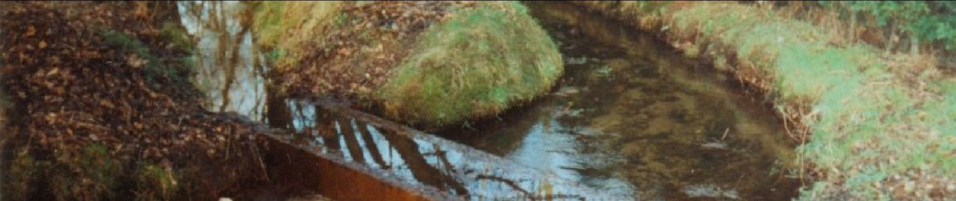
Het wandelpad loopt gedeeltelijk over particulier terrein, waar soms vee loopt. Om de dieren niet te verstoren en verspreiding van dierziekten te voorkomen zijn honden verboden.
Symbole: Bruine klompen / Brown wooden shoes
Site web: https://klompenpaden.nl/klompenpad/loenense-enkenpad/
Localisation
Commentaires
Randonnées à proximité
![Randonnée A pied Apeldoorn - Albapad - Photo](https://media.geolcdn.com/t/375/260/8c7e50c9-acb6-438d-a3e2-df78b5be7afe.jpeg&format=jpg&maxdim=2)
![A pied A pied](https://static1.geolcdn.com/sitytour/trail-icons/100.png)
![Randonnée A pied Apeldoorn - Deelerwoud - Blauw - Photo](https://media.geolcdn.com/t/375/260/8d358043-249e-47c4-b472-94e6d95606b2.jpeg&format=jpg&maxdim=2)
![A pied A pied](https://static1.geolcdn.com/sitytour/trail-icons/100.png)
A pied
![](/images/other/stat-length.png)
![](https://static1.geolcdn.com/siteimages/upload/files/16400158638029165_repeat_loop_refresh_sync_direction_icon.png)
![Randonnée A pied Apeldoorn - Welkom op de Loenermark! Zwarte route - Photo](https://media.geolcdn.com/t/375/260/10811004-b4fa-4eda-a748-884a8844bfad.jpeg&format=jpg&maxdim=2)
![A pied A pied](https://static1.geolcdn.com/sitytour/trail-icons/100.png)
A pied
![](/images/other/stat-length.png)
![](https://static1.geolcdn.com/siteimages/upload/files/16400158638029165_repeat_loop_refresh_sync_direction_icon.png)
![Randonnée A pied Apeldoorn - Welkom op de Loenermark! Blauwe route - Photo](https://media.geolcdn.com/t/375/260/10811004-b4fa-4eda-a748-884a8844bfad.jpeg&format=jpg&maxdim=2)
![A pied A pied](https://static1.geolcdn.com/sitytour/trail-icons/100.png)
A pied
![](/images/other/stat-length.png)
![](https://static1.geolcdn.com/siteimages/upload/files/16400158638029165_repeat_loop_refresh_sync_direction_icon.png)
![Randonnée A pied Brummen - Dwars door Gelderland (17) - Photo](https://media.geolcdn.com/t/375/260/5073ca41-17a8-411f-ab5c-9a92f3d474d4.jpeg&format=jpg&maxdim=2)
![A pied A pied](https://static1.geolcdn.com/sitytour/trail-icons/100.png)
A pied
![](/images/other/stat-length.png)
![](https://static1.geolcdn.com/siteimages/upload/files/16400158638029165_repeat_loop_refresh_sync_direction_icon.png)
![Randonnée A pied Rheden - Dwars door Gelderland (16) - Photo](https://media.geolcdn.com/t/375/260/9668913b-94cf-4fa2-82c3-acaa17e5951a.jpeg&format=jpg&maxdim=2)
![A pied A pied](https://static1.geolcdn.com/sitytour/trail-icons/100.png)
A pied
![](/images/other/stat-length.png)
![](https://static1.geolcdn.com/siteimages/upload/files/16400158638029165_repeat_loop_refresh_sync_direction_icon.png)
![Randonnée Marche Apeldoorn - Reeëndal in Loenen (gld) - Photo](https://media.geolcdn.com/t/375/260/a36c921c-a500-4542-8d1f-aa8f8e392d17.jpg&format=jpg&maxdim=2)
![Marche Marche](https://static1.geolcdn.com/sitytour/trail-icons/101.png)
Marche
![](/images/other/stat-length.png)
![](https://static1.geolcdn.com/siteimages/upload/files/16400158638029165_repeat_loop_refresh_sync_direction_icon.png)
![Randonnée Vélo Brummen - Gelderland - Veluwezoomtocht - Photo](https://media.geolcdn.com/t/375/260/ext.jpg?maxdim=2&url=https%3A%2F%2Fstatic1.geolcdn.com%2Fsiteimages%2Fupload%2Ffiles%2F1524743154velo.jpg)
![Vélo Vélo](https://static1.geolcdn.com/sitytour/trail-icons/200.png)
Vélo
![](/images/other/stat-length.png)
![](https://static1.geolcdn.com/siteimages/upload/files/16400158638029165_repeat_loop_refresh_sync_direction_icon.png)
![Randonnée Vélo Apeldoorn - f-gelderland-loenen-posbank - Photo](https://media.geolcdn.com/t/375/260/ext.jpg?maxdim=2&url=https%3A%2F%2Fstatic1.geolcdn.com%2Fsiteimages%2Fupload%2Ffiles%2F1524743154velo.jpg)
![Vélo Vélo](https://static1.geolcdn.com/sitytour/trail-icons/200.png)
Vélo
![](/images/other/stat-length.png)
![](https://static1.geolcdn.com/siteimages/upload/files/16400158638029165_repeat_loop_refresh_sync_direction_icon.png)