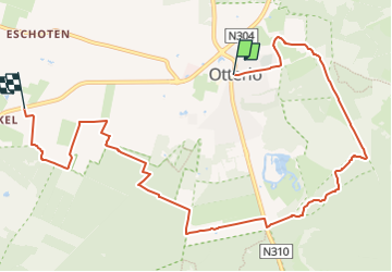
![](/images/other/stat-length.png)
![Randonnée A pied Ede - Eeskoterpad Hoofdroute - Photo](https://media.geolcdn.com/t/1900/400/e2f65f19-74e1-4956-acc1-7c70f7bfadb3.jpeg&format=pjpeg&maxdim=2)
Eeskoterpad Hoofdroute
SityTrail - itinéraires balisés pédestres
Tous les sentiers balisés d’Europe GUIDE+
![Longueur](/images/other/stat-length.png)
Longueur
9,1 km
![Altitude max](https://static1.geolcdn.com/siteimages/upload/files/1508320355ic_sort_altitude_max_24dp.png)
Altitude max
41 m
![Dénivelé positif](https://static1.geolcdn.com/siteimages/upload/files/1508320355ic_sort_den_pos_24dp.png)
Dénivelé positif
48 m
![Km-Effort](/images/other/stat-length.png)
Km-Effort
9,7 km
![Altitude min](https://static1.geolcdn.com/siteimages/upload/files/1508320355ic_sort_altitude_min_24dp.png)
Altitude min
20 m
![Dénivelé négatif](https://static1.geolcdn.com/siteimages/upload/files/1508320355ic_sort_den_neg_24dp.png)
Dénivelé négatif
55 m
![Boucle](https://static1.geolcdn.com/siteimages/upload/files/16400158638029165_repeat_loop_refresh_sync_direction_icon.png)
Boucle
Non
Balise
Date de création :
2022-02-14 15:28:50.046
Dernière modification :
2022-02-14 15:28:50.046
![A pied](https://static1.geolcdn.com/sitytour/trail-icons/100.png)
2h12
Difficulté : Facile
![Scannez ce code QR pour ouvrir la randonnée dans l'application SityTrail](https://capi.geolives.com/qq0zvz2zws4bq2lad0pu/sitytour/trails/3110211/qr.png?size=200)
Application GPS de randonnée GRATUITE
À propos
Randonnée A pied de 9,1 km à découvrir à Gueldre, Inconnu, Ede. Cette randonnée est proposée par SityTrail - itinéraires balisés pédestres.
Description
Symbole: green clogs
Site web: http://www.klompenpaden.nl/alle-klompenpaden/gelderland/223-eeskooterpad.html
Localisation
Pays :
Pays-Bas
Région :
Gueldre
Département/Province :
Inconnu
Commune :
Ede
Localité :
Unknown
Départ:(Dec)
Départ:(UTM)
689841 ; 5775945 (31U) N.
Commentaires
Randonnées à proximité
![Randonnée A pied Ede - Eeskoterpad - Photo](https://media.geolcdn.com/t/375/260/e2f65f19-74e1-4956-acc1-7c70f7bfadb3.jpeg&format=jpg&maxdim=2)
![A pied A pied](https://static1.geolcdn.com/sitytour/trail-icons/100.png)
![Randonnée Vélo Ede - Otterlo Hoge Veluwe (PVDB) - Photo](https://media.geolcdn.com/t/375/260/81ea02ee-c686-45bb-a28c-c710c8260806.jpg&format=jpg&maxdim=2)
![Vélo Vélo](https://static1.geolcdn.com/sitytour/trail-icons/200.png)
Otterlo Hoge Veluwe (PVDB)
Vélo
Moyen
Ede,
Gueldre,
Inconnu,
Pays-Bas
![](/images/other/stat-length.png)
38 km | 42 km-effort
3h 35min
![](https://static1.geolcdn.com/siteimages/upload/files/16400158638029165_repeat_loop_refresh_sync_direction_icon.png)
Oui
![Randonnée Vélo Ede - f-gelderland-leuke-fietstocht-op-de-veluwe - Photo](https://media.geolcdn.com/t/375/260/ext.jpg?maxdim=2&url=https%3A%2F%2Fstatic1.geolcdn.com%2Fsiteimages%2Fupload%2Ffiles%2F1524743154velo.jpg)
![Vélo Vélo](https://static1.geolcdn.com/sitytour/trail-icons/200.png)
f-gelderland-leuke-fietstocht-op-de-veluwe
Vélo
Très facile
Ede,
Gueldre,
Inconnu,
Pays-Bas
![](/images/other/stat-length.png)
15,8 km | 17,5 km-effort
Inconnu
![](https://static1.geolcdn.com/siteimages/upload/files/16400158638029165_repeat_loop_refresh_sync_direction_icon.png)
Oui
![Randonnée Marche Ede - w-geldeland-hoge-veluwe - Photo](https://media.geolcdn.com/t/375/260/ext.jpg?maxdim=2&url=https%3A%2F%2Fstatic1.geolcdn.com%2Fsiteimages%2Fupload%2Ffiles%2F1553511878bg_sport_marche.png)
![Marche Marche](https://static1.geolcdn.com/sitytour/trail-icons/101.png)
w-geldeland-hoge-veluwe
Marche
Très facile
Ede,
Gueldre,
Inconnu,
Pays-Bas
![](/images/other/stat-length.png)
12,7 km | 13,9 km-effort
Inconnu
![](https://static1.geolcdn.com/siteimages/upload/files/16400158638029165_repeat_loop_refresh_sync_direction_icon.png)
Oui
![Randonnée A pied Ede - Hoge Weluwe au départ de Otterlo - Photo](https://media.geolcdn.com/t/375/260/ext.jpg?maxdim=2&url=https%3A%2F%2Fstatic1.geolcdn.com%2Fsiteimages%2Fupload%2Ffiles%2F1545311037marcheuse_200dpi.jpg)
![A pied A pied](https://static1.geolcdn.com/sitytour/trail-icons/100.png)
Hoge Weluwe au départ de Otterlo
A pied
Facile
Ede,
Gueldre,
Inconnu,
Pays-Bas
![](/images/other/stat-length.png)
11 km | 12,3 km-effort
2h 47min
![](https://static1.geolcdn.com/siteimages/upload/files/16400158638029165_repeat_loop_refresh_sync_direction_icon.png)
Oui
![Randonnée Cyclotourisme Ede - Gélule - Photo](https://media.geolcdn.com/t/375/260/ext.jpg?maxdim=2&url=https%3A%2F%2Fstatic1.geolcdn.com%2Fsiteimages%2Fupload%2Ffiles%2F1524743154velo.jpg)
![Cyclotourisme Cyclotourisme](https://static1.geolcdn.com/sitytour/trail-icons/204.png)
![Randonnée Cyclotourisme Ede - Hoge Veluwe - Photo](https://media.geolcdn.com/t/375/260/ext.jpg?maxdim=2&url=https%3A%2F%2Fstatic1.geolcdn.com%2Fsiteimages%2Fupload%2Ffiles%2F1524743154velo.jpg)
![Cyclotourisme Cyclotourisme](https://static1.geolcdn.com/sitytour/trail-icons/204.png)
Hoge Veluwe
Cyclotourisme
Très facile
Ede,
Gueldre,
Inconnu,
Pays-Bas
![](/images/other/stat-length.png)
32 km | 35 km-effort
6h 2min
![](https://static1.geolcdn.com/siteimages/upload/files/16400158638029165_repeat_loop_refresh_sync_direction_icon.png)
Non