![](/images/other/stat-length.png)
![Randonnée A pied La Haye - NS-wandeling Meijendel - Photo](https://media.geolcdn.com/t/1900/400/6c24e446-94f5-490a-afd2-d15b11b6a22d.jpeg&format=pjpeg&maxdim=2)
NS-wandeling Meijendel
SityTrail - itinéraires balisés pédestres
Tous les sentiers balisés d’Europe GUIDE+
![Longueur](/images/other/stat-length.png)
Longueur
13,2 km
![Altitude max](https://static1.geolcdn.com/siteimages/upload/files/1508320355ic_sort_altitude_max_24dp.png)
Altitude max
16 m
![Dénivelé positif](https://static1.geolcdn.com/siteimages/upload/files/1508320355ic_sort_den_pos_24dp.png)
Dénivelé positif
94 m
![Km-Effort](/images/other/stat-length.png)
Km-Effort
14,5 km
![Altitude min](https://static1.geolcdn.com/siteimages/upload/files/1508320355ic_sort_altitude_min_24dp.png)
Altitude min
-2 m
![Dénivelé négatif](https://static1.geolcdn.com/siteimages/upload/files/1508320355ic_sort_den_neg_24dp.png)
Dénivelé négatif
96 m
![Boucle](https://static1.geolcdn.com/siteimages/upload/files/16400158638029165_repeat_loop_refresh_sync_direction_icon.png)
Boucle
Non
Balise
Date de création :
2022-02-14 15:25:32.441
Dernière modification :
2022-02-14 15:25:32.441
![A pied](https://static1.geolcdn.com/sitytour/trail-icons/100.png)
3h17
Difficulté : Facile
![Scannez ce code QR pour ouvrir la randonnée dans l'application SityTrail](https://capi.geolives.com/qq0zvz2zws4bq2lad0pu/sitytour/trails/3110178/qr.png?size=200)
Application GPS de randonnée GRATUITE
À propos
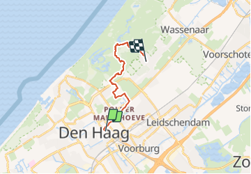
Randonnée A pied de 13,2 km à découvrir à Hollande-Méridionale, Inconnu, La Haye. Cette randonnée est proposée par SityTrail - itinéraires balisés pédestres.
Description
Wandel vanaf Den Haag Centraal door de bossen en de duinen.
Site web: https://www.ns.nl/dagje-uit/wandelen/meijendel.html
Localisation
Pays :
Pays-Bas
Région :
Hollande-Méridionale
Département/Province :
Inconnu
Commune :
La Haye
Localité :
Unknown
Départ:(Dec)
Départ:(UTM)
590657 ; 5770877 (31U) N.
Commentaires
Randonnées à proximité
![Randonnée Vélo Ryswick - Fietsroute in Den Haag - Photo](https://media.geolcdn.com/t/375/260/ext.jpg?maxdim=2&url=https%3A%2F%2Fservices.sitytrail.com%2FGeolivesWS%2FDownloadMedia.ashx%3FTrailID%3D112924%26Media%3Dc8fe9f09-7d23-4c32-8cc8-f12dff499768.png)
![Vélo Vélo](https://static1.geolcdn.com/sitytour/trail-icons/200.png)
Fietsroute in Den Haag
Vélo
Facile
(1)
Ryswick,
Hollande-Méridionale,
Inconnu,
Pays-Bas
![](/images/other/stat-length.png)
15,5 km | 16,5 km-effort
58min
![](https://static1.geolcdn.com/siteimages/upload/files/16400158638029165_repeat_loop_refresh_sync_direction_icon.png)
Oui
![Randonnée Marche La Haye - Zuid-Holland - Waalsdorpervlakte Meyendel en strand - Photo](https://media.geolcdn.com/t/375/260/ext.jpg?maxdim=2&url=https%3A%2F%2Fstatic1.geolcdn.com%2Fsiteimages%2Fupload%2Ffiles%2F1553511878bg_sport_marche.png)
![Marche Marche](https://static1.geolcdn.com/sitytour/trail-icons/101.png)
Zuid-Holland - Waalsdorpervlakte Meyendel en strand
Marche
Très facile
(1)
La Haye,
Hollande-Méridionale,
Inconnu,
Pays-Bas
![](/images/other/stat-length.png)
12,3 km | 13,3 km-effort
Inconnu
![](https://static1.geolcdn.com/siteimages/upload/files/16400158638029165_repeat_loop_refresh_sync_direction_icon.png)
Oui
![Randonnée A pied La Haye - Monumentale bomen- en hofjesroute - Photo](https://media.geolcdn.com/t/375/260/c9449f43-f06d-4b0b-affa-2929ab655377.jpeg&format=jpg&maxdim=2)
![A pied A pied](https://static1.geolcdn.com/sitytour/trail-icons/100.png)
Monumentale bomen- en hofjesroute
A pied
Facile
La Haye,
Hollande-Méridionale,
Inconnu,
Pays-Bas
![](/images/other/stat-length.png)
4,6 km | 4,9 km-effort
1h 7min
![](https://static1.geolcdn.com/siteimages/upload/files/16400158638029165_repeat_loop_refresh_sync_direction_icon.png)
Non
![Randonnée A pied La Haye - Groen met historie - Photo](https://media.geolcdn.com/t/375/260/5bc20cb0-b310-454a-ac19-ad713442ed35.jpeg&format=jpg&maxdim=2)
![A pied A pied](https://static1.geolcdn.com/sitytour/trail-icons/100.png)
Groen met historie
A pied
Facile
La Haye,
Hollande-Méridionale,
Inconnu,
Pays-Bas
![](/images/other/stat-length.png)
4,1 km | 4,4 km-effort
59min
![](https://static1.geolcdn.com/siteimages/upload/files/16400158638029165_repeat_loop_refresh_sync_direction_icon.png)
Oui
![Randonnée A pied Wassenaar - Gele wandelroute Clingendael - Photo](https://media.geolcdn.com/t/375/260/0aab8b00-b6d9-4d29-ba30-e423f1436156.jpeg&format=jpg&maxdim=2)
![A pied A pied](https://static1.geolcdn.com/sitytour/trail-icons/100.png)
Gele wandelroute Clingendael
A pied
Facile
Wassenaar,
Hollande-Méridionale,
Inconnu,
Pays-Bas
![](/images/other/stat-length.png)
3,7 km | 4,2 km-effort
56min
![](https://static1.geolcdn.com/siteimages/upload/files/16400158638029165_repeat_loop_refresh_sync_direction_icon.png)
Oui
![Randonnée Marche La Haye - schevening-la plage - Photo](https://media.geolcdn.com/t/375/260/ext.jpg?maxdim=2&url=https%3A%2F%2Fservices.sitytrail.com%2FGeolivesWS%2FDownloadMedia.ashx%3FTrailID%3D425172%26Media%3Dfix__20150524190732.jpg)
![Marche Marche](https://static1.geolcdn.com/sitytour/trail-icons/101.png)
schevening-la plage
Marche
Très facile
La Haye,
Hollande-Méridionale,
Inconnu,
Pays-Bas
![](/images/other/stat-length.png)
6,6 km | 7 km-effort
1h 55min
![](https://static1.geolcdn.com/siteimages/upload/files/16400158638029165_repeat_loop_refresh_sync_direction_icon.png)
Oui
![Randonnée Cyclotourisme La Haye - NL.Voorburg.64.361VTC - Photo](https://media.geolcdn.com/t/375/260/ext.jpg?maxdim=2&url=https%3A%2F%2Fstatic1.geolcdn.com%2Fsiteimages%2Fupload%2Ffiles%2F1524743154velo.jpg)
![Cyclotourisme Cyclotourisme](https://static1.geolcdn.com/sitytour/trail-icons/204.png)
NL.Voorburg.64.361VTC
Cyclotourisme
Très facile
La Haye,
Hollande-Méridionale,
Inconnu,
Pays-Bas
![](/images/other/stat-length.png)
64 km | 68 km-effort
Inconnu
![](https://static1.geolcdn.com/siteimages/upload/files/16400158638029165_repeat_loop_refresh_sync_direction_icon.png)
Oui
![Randonnée Marche La Haye - la haye1 - Photo](https://media.geolcdn.com/t/375/260/1db7cc69-ce98-4928-935e-30bd597de254.jpg&format=jpg&maxdim=2)
![Marche Marche](https://static1.geolcdn.com/sitytour/trail-icons/101.png)
la haye1
Marche
Très facile
La Haye,
Hollande-Méridionale,
Inconnu,
Pays-Bas
![](/images/other/stat-length.png)
7,5 km | 8,2 km-effort
2h 34min
![](https://static1.geolcdn.com/siteimages/upload/files/16400158638029165_repeat_loop_refresh_sync_direction_icon.png)
Oui
![Randonnée Moteur La Haye - a-zholland-rondje-muiden - Photo](https://media.geolcdn.com/t/375/260/ext.jpg?maxdim=2&url=https%3A%2F%2Fstatic1.geolcdn.com%2Fsiteimages%2Fupload%2Ffiles%2F15247431544x4.jpg)
![Moteur Moteur](https://static1.geolcdn.com/sitytour/trail-icons/400.png)
a-zholland-rondje-muiden
Moteur
Très facile
La Haye,
Hollande-Méridionale,
Inconnu,
Pays-Bas
![](/images/other/stat-length.png)
164 km | 172 km-effort
Inconnu
![](https://static1.geolcdn.com/siteimages/upload/files/16400158638029165_repeat_loop_refresh_sync_direction_icon.png)
Oui