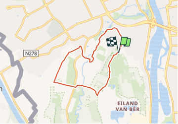
![](/images/other/stat-length.png)
![Randonnée A pied Maastricht - 1.Fort Saint-Pierre: Carreau Bleu - Photo](https://media.geolcdn.com/t/1900/400/dev_32a15781-187e-43ff-a6fd-ea774194b274.jpeg&format=pjpeg&maxdim=2)
1.Fort Saint-Pierre: Carreau Bleu
SityTrail - itinéraires balisés pédestres
Tous les sentiers balisés d’Europe GUIDE+
![Longueur](/images/other/stat-length.png)
![Altitude max](https://static1.geolcdn.com/siteimages/upload/files/1508320355ic_sort_altitude_max_24dp.png)
![Dénivelé positif](https://static1.geolcdn.com/siteimages/upload/files/1508320355ic_sort_den_pos_24dp.png)
![Km-Effort](/images/other/stat-length.png)
![Altitude min](https://static1.geolcdn.com/siteimages/upload/files/1508320355ic_sort_altitude_min_24dp.png)
![Dénivelé négatif](https://static1.geolcdn.com/siteimages/upload/files/1508320355ic_sort_den_neg_24dp.png)
![Boucle](https://static1.geolcdn.com/siteimages/upload/files/16400158638029165_repeat_loop_refresh_sync_direction_icon.png)
![A pied](https://static1.geolcdn.com/sitytour/trail-icons/100.png)
1h44
Difficulté : Facile
![Scannez ce code QR pour ouvrir la randonnée dans l'application SityTrail](https://capi.geolives.com/qq0zvz2zws4bq2lad0pu/sitytour/trails/3110170/qr.png?size=200)
Application GPS de randonnée GRATUITE
À propos
Randonnée A pied de 6,1 km à découvrir à Limbourg, Inconnu, Maastricht. Cette randonnée est proposée par SityTrail - itinéraires balisés pédestres.
Description
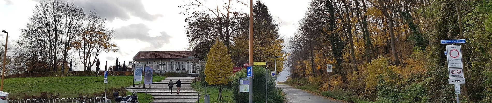
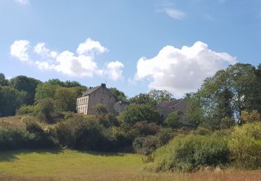
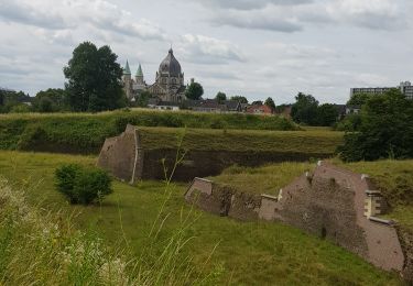
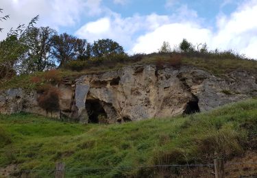
Het kalkmassief van de Sint-Pietersberg ligt op de grens van Nederland, Vlaanderen en Wallonië. Dit is een unieke streek, met pittoreske dorpjes, forten en kastelen, tal van waterlopen, een bewogen geschiedenis en een uitzonderlijke natuur.
Site web: http://www.sintpietersberg.org
Localisation
Commentaires
Randonnées à proximité
![Randonnée Marche Eijsden-Margraten - Eijsden - E8 - Bloesemroute-3 - Photo](https://media.geolcdn.com/t/375/260/7792b7db-95a9-4b53-8cd5-7eae3fedc6a4.jpg&format=jpg&maxdim=2)
![Marche Marche](https://static1.geolcdn.com/sitytour/trail-icons/101.png)
Marche
![](/images/other/stat-length.png)
![](https://static1.geolcdn.com/siteimages/upload/files/16400158638029165_repeat_loop_refresh_sync_direction_icon.png)
![Randonnée Marche Riemst - Kanne_1192 - Photo](https://media.geolcdn.com/t/375/260/63b86f10-f314-488d-80d4-00787e3a9126.jpg&format=jpg&maxdim=2)
![Marche Marche](https://static1.geolcdn.com/sitytour/trail-icons/101.png)
![Randonnée Marche Maastricht - Maastricht_1693. - Photo](https://media.geolcdn.com/t/375/260/35d0d485-5909-42ec-b3f4-9d96e17c2c7d.jpg&format=jpg&maxdim=2)
![Marche Marche](https://static1.geolcdn.com/sitytour/trail-icons/101.png)
Marche
![](/images/other/stat-length.png)
![](https://static1.geolcdn.com/siteimages/upload/files/16400158638029165_repeat_loop_refresh_sync_direction_icon.png)
![Randonnée Marche Eijsden-Margraten - Gronsveld_1327 - Photo](https://media.geolcdn.com/t/375/260/877eed2d-204c-4212-a49e-caf4fc574b56.jpg&format=jpg&maxdim=2)
![Marche Marche](https://static1.geolcdn.com/sitytour/trail-icons/101.png)
Marche
![](/images/other/stat-length.png)
![](https://static1.geolcdn.com/siteimages/upload/files/16400158638029165_repeat_loop_refresh_sync_direction_icon.png)
![Randonnée Marche Maastricht - Maastricht - Hoge Fronten & 't Bassin - Photo](https://media.geolcdn.com/t/375/260/0d1db1de-c9bf-433a-9df4-c07031a55999.jpg&format=jpg&maxdim=2)
![Marche Marche](https://static1.geolcdn.com/sitytour/trail-icons/101.png)
Marche
![](/images/other/stat-length.png)
![](https://static1.geolcdn.com/siteimages/upload/files/16400158638029165_repeat_loop_refresh_sync_direction_icon.png)
![Randonnée Marche Maastricht - Maastricht _1540 - Photo](https://media.geolcdn.com/t/375/260/8e415027-26b4-4bc6-9623-75f03f38b59c.jpg&format=jpg&maxdim=2)
![Marche Marche](https://static1.geolcdn.com/sitytour/trail-icons/101.png)
Marche
![](/images/other/stat-length.png)
![](https://static1.geolcdn.com/siteimages/upload/files/16400158638029165_repeat_loop_refresh_sync_direction_icon.png)
![Randonnée Marche Maastricht - Maastricht_1459 - Photo](https://media.geolcdn.com/t/375/260/bd8acbf6-ee38-4b48-89c0-97eec4bf77bd.jpg&format=jpg&maxdim=2)
![Marche Marche](https://static1.geolcdn.com/sitytour/trail-icons/101.png)
Marche
![](/images/other/stat-length.png)
![](https://static1.geolcdn.com/siteimages/upload/files/16400158638029165_repeat_loop_refresh_sync_direction_icon.png)
![Randonnée Marche Maastricht - Maastricht _1087 - Photo](https://media.geolcdn.com/t/375/260/23f3cb69-ec7d-4156-85e2-e9b9420f412b.jpg&format=jpg&maxdim=2)
![Marche Marche](https://static1.geolcdn.com/sitytour/trail-icons/101.png)
Marche
![](/images/other/stat-length.png)
![](https://static1.geolcdn.com/siteimages/upload/files/16400158638029165_repeat_loop_refresh_sync_direction_icon.png)
![Randonnée Marche Maastricht - Gronsveld _280 - Photo](https://media.geolcdn.com/t/375/260/68c18dc9-dcb8-48e4-b64a-8d1fd453745f.jpg&format=jpg&maxdim=2)
![Marche Marche](https://static1.geolcdn.com/sitytour/trail-icons/101.png)
Marche
![](/images/other/stat-length.png)
![](https://static1.geolcdn.com/siteimages/upload/files/16400158638029165_repeat_loop_refresh_sync_direction_icon.png)