![](/images/other/stat-length.png)
![Randonnée A pied Noordwijk - Maloteroute - Photo](https://media.geolcdn.com/t/1900/400/8368ff9f-25ae-4bf4-898b-a94c832a3675.jpeg&format=pjpeg&maxdim=2)
Maloteroute
SityTrail - itinéraires balisés pédestres
Tous les sentiers balisés d’Europe GUIDE+
![Longueur](/images/other/stat-length.png)
Longueur
4,8 km
![Altitude max](https://static1.geolcdn.com/siteimages/upload/files/1508320355ic_sort_altitude_max_24dp.png)
Altitude max
18 m
![Dénivelé positif](https://static1.geolcdn.com/siteimages/upload/files/1508320355ic_sort_den_pos_24dp.png)
Dénivelé positif
26 m
![Km-Effort](/images/other/stat-length.png)
Km-Effort
5,1 km
![Altitude min](https://static1.geolcdn.com/siteimages/upload/files/1508320355ic_sort_altitude_min_24dp.png)
Altitude min
7 m
![Dénivelé négatif](https://static1.geolcdn.com/siteimages/upload/files/1508320355ic_sort_den_neg_24dp.png)
Dénivelé négatif
28 m
![Boucle](https://static1.geolcdn.com/siteimages/upload/files/16400158638029165_repeat_loop_refresh_sync_direction_icon.png)
Boucle
Non
Balise
Date de création :
2022-02-14 15:24:01.202
Dernière modification :
2022-02-14 15:24:01.202
![A pied](https://static1.geolcdn.com/sitytour/trail-icons/100.png)
1h09
Difficulté : Facile
![Scannez ce code QR pour ouvrir la randonnée dans l'application SityTrail](https://capi.geolives.com/qq0zvz2zws4bq2lad0pu/sitytour/trails/3110145/qr.png?size=200)
Application GPS de randonnée GRATUITE
À propos
Randonnée A pied de 4,8 km à découvrir à Hollande-Méridionale, Inconnu, Noordwijk. Cette randonnée est proposée par SityTrail - itinéraires balisés pédestres.
Description
Randonnée créée par Staatsbosbeheer.
Symbole: ronde palen met blauwe kop
Localisation
Pays :
Pays-Bas
Région :
Hollande-Méridionale
Département/Province :
Inconnu
Commune :
Noordwijk
Localité :
Unknown
Départ:(Dec)
Départ:(UTM)
599060 ; 5790733 (31U) N.
Commentaires
Randonnées à proximité
![Randonnée A pied Noordwijk - Zandhagedisroute - Photo](https://media.geolcdn.com/t/375/260/1a3bba1d-a9ba-43b3-a795-5e7639e981d6.jpeg&format=jpg&maxdim=2)
![A pied A pied](https://static1.geolcdn.com/sitytour/trail-icons/100.png)
Zandhagedisroute
A pied
Facile
Noordwijk,
Hollande-Méridionale,
Inconnu,
Pays-Bas
![](/images/other/stat-length.png)
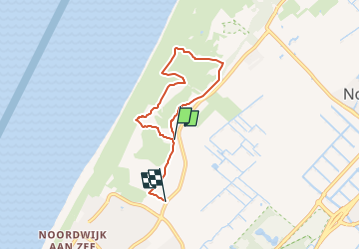
8,1 km | 9,1 km-effort
2h 3min
![](https://static1.geolcdn.com/siteimages/upload/files/16400158638029165_repeat_loop_refresh_sync_direction_icon.png)
Oui
![Randonnée A pied Noordwijk - Langeveldwandeling - Photo](https://media.geolcdn.com/t/375/260/b3165bed-e345-441d-a394-9d5653dcd4ab.jpeg&format=jpg&maxdim=2)
![A pied A pied](https://static1.geolcdn.com/sitytour/trail-icons/100.png)
Langeveldwandeling
A pied
Facile
Noordwijk,
Hollande-Méridionale,
Inconnu,
Pays-Bas
![](/images/other/stat-length.png)
3,5 km | 3,9 km-effort
53min
![](https://static1.geolcdn.com/siteimages/upload/files/16400158638029165_repeat_loop_refresh_sync_direction_icon.png)
Oui
![Randonnée A pied Noordwijk - Kachelduinroute - Photo](https://media.geolcdn.com/t/375/260/eb07b931-a8f0-48ce-bb5c-ced1c26d976f.jpeg&format=jpg&maxdim=2)
![A pied A pied](https://static1.geolcdn.com/sitytour/trail-icons/100.png)
Kachelduinroute
A pied
Facile
Noordwijk,
Hollande-Méridionale,
Inconnu,
Pays-Bas
![](/images/other/stat-length.png)
3,5 km | 3,8 km-effort
52min
![](https://static1.geolcdn.com/siteimages/upload/files/16400158638029165_repeat_loop_refresh_sync_direction_icon.png)
Oui
![Randonnée A pied Noordwijk - Kunst in duinpad - Photo](https://media.geolcdn.com/t/375/260/eb07b931-a8f0-48ce-bb5c-ced1c26d976f.jpeg&format=jpg&maxdim=2)
![A pied A pied](https://static1.geolcdn.com/sitytour/trail-icons/100.png)
Kunst in duinpad
A pied
Facile
Noordwijk,
Hollande-Méridionale,
Inconnu,
Pays-Bas
![](/images/other/stat-length.png)
3,5 km | 3,9 km-effort
52min
![](https://static1.geolcdn.com/siteimages/upload/files/16400158638029165_repeat_loop_refresh_sync_direction_icon.png)
Oui
![Randonnée Moteur Noordwijk - a-zholland-rondje-noordwijk-groene-hart - Photo](https://media.geolcdn.com/t/375/260/ext.jpg?maxdim=2&url=https%3A%2F%2Fstatic1.geolcdn.com%2Fsiteimages%2Fupload%2Ffiles%2F15247431544x4.jpg)
![Moteur Moteur](https://static1.geolcdn.com/sitytour/trail-icons/400.png)
a-zholland-rondje-noordwijk-groene-hart
Moteur
Très facile
Noordwijk,
Hollande-Méridionale,
Inconnu,
Pays-Bas
![](/images/other/stat-length.png)
115 km | 120 km-effort
Inconnu
![](https://static1.geolcdn.com/siteimages/upload/files/16400158638029165_repeat_loop_refresh_sync_direction_icon.png)
Non
![Randonnée Vélo Noordwijk - Zuid-Holland - Bollen en Branding - Photo](https://media.geolcdn.com/t/375/260/ext.jpg?maxdim=2&url=https%3A%2F%2Fstatic1.geolcdn.com%2Fsiteimages%2Fupload%2Ffiles%2F1524743154velo.jpg)
![Vélo Vélo](https://static1.geolcdn.com/sitytour/trail-icons/200.png)
Zuid-Holland - Bollen en Branding
Vélo
Très facile
Noordwijk,
Hollande-Méridionale,
Inconnu,
Pays-Bas
![](/images/other/stat-length.png)
40 km | 42 km-effort
Inconnu
![](https://static1.geolcdn.com/siteimages/upload/files/16400158638029165_repeat_loop_refresh_sync_direction_icon.png)
Oui
![Randonnée V.T.T. Noordwijk - Zuid-Holland - Vaste MTBroute Noordwijkerhout - Photo](https://media.geolcdn.com/t/375/260/ext.jpg?maxdim=2&url=https%3A%2F%2Fstatic1.geolcdn.com%2Fsiteimages%2Fupload%2Ffiles%2F1524743154velo.jpg)
![V.T.T. V.T.T.](https://static1.geolcdn.com/sitytour/trail-icons/202.png)
Zuid-Holland - Vaste MTBroute Noordwijkerhout
V.T.T.
Très facile
Noordwijk,
Hollande-Méridionale,
Inconnu,
Pays-Bas
![](/images/other/stat-length.png)
7,5 km | 8,3 km-effort
Inconnu
![](https://static1.geolcdn.com/siteimages/upload/files/16400158638029165_repeat_loop_refresh_sync_direction_icon.png)
Oui
![Randonnée V.T.T. Noordwijk - m-nholland-vaste-atbroute-noordwijkerhout - Photo](https://media.geolcdn.com/t/375/260/ext.jpg?maxdim=2&url=https%3A%2F%2Fstatic1.geolcdn.com%2Fsiteimages%2Fupload%2Ffiles%2F1524743154velo.jpg)
![V.T.T. V.T.T.](https://static1.geolcdn.com/sitytour/trail-icons/202.png)
m-nholland-vaste-atbroute-noordwijkerhout
V.T.T.
Très facile
Noordwijk,
Hollande-Méridionale,
Inconnu,
Pays-Bas
![](/images/other/stat-length.png)
7,5 km | 8,2 km-effort
Inconnu
![](https://static1.geolcdn.com/siteimages/upload/files/16400158638029165_repeat_loop_refresh_sync_direction_icon.png)
Oui
![Randonnée Marche Noordwijk - w-zholland-langeveldseslag-en-waterleidingduinen - Photo](https://media.geolcdn.com/t/375/260/ext.jpg?maxdim=2&url=https%3A%2F%2Fstatic1.geolcdn.com%2Fsiteimages%2Fupload%2Ffiles%2F1553511878bg_sport_marche.png)
![Marche Marche](https://static1.geolcdn.com/sitytour/trail-icons/101.png)
w-zholland-langeveldseslag-en-waterleidingduinen
Marche
Très facile
(1)
Noordwijk,
Hollande-Méridionale,
Inconnu,
Pays-Bas
![](/images/other/stat-length.png)
19,1 km | 21 km-effort
Inconnu
![](https://static1.geolcdn.com/siteimages/upload/files/16400158638029165_repeat_loop_refresh_sync_direction_icon.png)
Oui