![](/images/other/stat-length.png)
![Randonnée A pied Apeldoorn - Holhorsterpad - Photo](https://media.geolcdn.com/t/1900/400/79826088-6f4e-41cc-9fc9-e8a68e73eb66.jpeg&format=pjpeg&maxdim=2)
Holhorsterpad
SityTrail - itinéraires balisés pédestres
Tous les sentiers balisés d’Europe GUIDE+
![Longueur](/images/other/stat-length.png)
Longueur
11,3 km
![Altitude max](https://static1.geolcdn.com/siteimages/upload/files/1508320355ic_sort_altitude_max_24dp.png)
Altitude max
16 m
![Dénivelé positif](https://static1.geolcdn.com/siteimages/upload/files/1508320355ic_sort_den_pos_24dp.png)
Dénivelé positif
53 m
![Km-Effort](/images/other/stat-length.png)
Km-Effort
12 km
![Altitude min](https://static1.geolcdn.com/siteimages/upload/files/1508320355ic_sort_altitude_min_24dp.png)
Altitude min
1 m
![Dénivelé négatif](https://static1.geolcdn.com/siteimages/upload/files/1508320355ic_sort_den_neg_24dp.png)
Dénivelé négatif
56 m
![Boucle](https://static1.geolcdn.com/siteimages/upload/files/16400158638029165_repeat_loop_refresh_sync_direction_icon.png)
Boucle
Oui
Balise
Date de création :
2022-02-14 15:23:27.187
Dernière modification :
2022-02-14 15:23:27.187
![A pied](https://static1.geolcdn.com/sitytour/trail-icons/100.png)
2h43
Difficulté : Facile
![Scannez ce code QR pour ouvrir la randonnée dans l'application SityTrail](https://capi.geolives.com/qq0zvz2zws4bq2lad0pu/sitytour/trails/3110113/qr.png?size=200)
Application GPS de randonnée GRATUITE
À propos
Randonnée A pied de 11,3 km à découvrir à Gueldre, Inconnu, Apeldoorn. Cette randonnée est proposée par SityTrail - itinéraires balisés pédestres.
Description
Ontdek het afwisselende buitengebied van Oldebroek en Wezep.
Site web: https://klompenpaden.nl/klompenpad/holhorsterpad
Localisation
Pays :
Pays-Bas
Région :
Gueldre
Département/Province :
Inconnu
Commune :
Apeldoorn
Localité :
Unknown
Départ:(Dec)
Départ:(UTM)
703185 ; 5791927 (31U) N.
Commentaires
Randonnées à proximité
![Randonnée A pied Apeldoorn - palieis 't Loo](https://media.geolcdn.com/t/375/260/1cc86ea8-6000-4f42-8824-a2a57d652512.jpeg&format=jpg&maxdim=2)
![A pied A pied](https://static1.geolcdn.com/sitytour/trail-icons/100.png)
palieis 't Loo "rode route (achtertuin)"
A pied
Facile
Apeldoorn,
Gueldre,
Inconnu,
Pays-Bas
![](/images/other/stat-length.png)
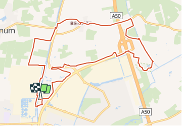
6 km | 6,8 km-effort
1h 32min
![](https://static1.geolcdn.com/siteimages/upload/files/16400158638029165_repeat_loop_refresh_sync_direction_icon.png)
Oui
![Randonnée A pied Apeldoorn - paleis 't Loo](https://media.geolcdn.com/t/375/260/c6ea6737-180f-4d07-bbfb-e15c3571876c.jpeg&format=jpg&maxdim=2)
![A pied A pied](https://static1.geolcdn.com/sitytour/trail-icons/100.png)
paleis 't Loo "zwarte route (achtertuin)"
A pied
Facile
Apeldoorn,
Gueldre,
Inconnu,
Pays-Bas
![](/images/other/stat-length.png)
4,2 km | 4,9 km-effort
1h 6min
![](https://static1.geolcdn.com/siteimages/upload/files/16400158638029165_repeat_loop_refresh_sync_direction_icon.png)
Non
![Randonnée A pied Apeldoorn - Kopermolenpad - Photo](https://media.geolcdn.com/t/375/260/31ccd019-f48e-4ab8-88f9-614ffc28b460.jpeg&format=jpg&maxdim=2)
![A pied A pied](https://static1.geolcdn.com/sitytour/trail-icons/100.png)
Kopermolenpad
A pied
Facile
Apeldoorn,
Gueldre,
Inconnu,
Pays-Bas
![](/images/other/stat-length.png)
13,2 km | 14,4 km-effort
3h 16min
![](https://static1.geolcdn.com/siteimages/upload/files/16400158638029165_repeat_loop_refresh_sync_direction_icon.png)
Oui
![Randonnée A pied Apeldoorn - Paleis 't Loo](https://media.geolcdn.com/t/375/260/1cc86ea8-6000-4f42-8824-a2a57d652512.jpeg&format=jpg&maxdim=2)
![A pied A pied](https://static1.geolcdn.com/sitytour/trail-icons/100.png)
Paleis 't Loo "blauwe route (achtertuin)"
A pied
Facile
Apeldoorn,
Gueldre,
Inconnu,
Pays-Bas
![](/images/other/stat-length.png)
4,5 km | 5,3 km-effort
1h 12min
![](https://static1.geolcdn.com/siteimages/upload/files/16400158638029165_repeat_loop_refresh_sync_direction_icon.png)
Oui
![Randonnée A pied Apeldoorn - Rondwandeling Paleis het Loo - Photo](https://media.geolcdn.com/t/375/260/d364927f-c612-4a3e-aa86-b15e43bd9d05.jpeg&format=jpg&maxdim=2)
![A pied A pied](https://static1.geolcdn.com/sitytour/trail-icons/100.png)
Rondwandeling Paleis het Loo
A pied
Facile
Apeldoorn,
Gueldre,
Inconnu,
Pays-Bas
![](/images/other/stat-length.png)
15,5 km | 18,1 km-effort
4h 6min
![](https://static1.geolcdn.com/siteimages/upload/files/16400158638029165_repeat_loop_refresh_sync_direction_icon.png)
Oui
![Randonnée Moteur Apeldoorn - a-gelderland-ensing-rondje-veluwe - Photo](https://media.geolcdn.com/t/375/260/ext.jpg?maxdim=2&url=https%3A%2F%2Fstatic1.geolcdn.com%2Fsiteimages%2Fupload%2Ffiles%2F15247431544x4.jpg)
![Moteur Moteur](https://static1.geolcdn.com/sitytour/trail-icons/400.png)
a-gelderland-ensing-rondje-veluwe
Moteur
Très facile
Apeldoorn,
Gueldre,
Inconnu,
Pays-Bas
![](/images/other/stat-length.png)
120 km | 134 km-effort
Inconnu
![](https://static1.geolcdn.com/siteimages/upload/files/16400158638029165_repeat_loop_refresh_sync_direction_icon.png)
Oui
![Randonnée Moteur Apeldoorn - a-gelderland-1000-bochten-rondje-veluwe - Photo](https://media.geolcdn.com/t/375/260/ext.jpg?maxdim=2&url=https%3A%2F%2Fstatic1.geolcdn.com%2Fsiteimages%2Fupload%2Ffiles%2F15247431544x4.jpg)
![Moteur Moteur](https://static1.geolcdn.com/sitytour/trail-icons/400.png)
a-gelderland-1000-bochten-rondje-veluwe
Moteur
Très facile
Apeldoorn,
Gueldre,
Inconnu,
Pays-Bas
![](/images/other/stat-length.png)
119 km | 132 km-effort
Inconnu
![](https://static1.geolcdn.com/siteimages/upload/files/16400158638029165_repeat_loop_refresh_sync_direction_icon.png)
Non
![Randonnée Vélo Apeldoorn - Gelderland - Veluwerit - Photo](https://media.geolcdn.com/t/375/260/ext.jpg?maxdim=2&url=https%3A%2F%2Fstatic1.geolcdn.com%2Fsiteimages%2Fupload%2Ffiles%2F1524743154velo.jpg)
![Vélo Vélo](https://static1.geolcdn.com/sitytour/trail-icons/200.png)
Gelderland - Veluwerit
Vélo
Très facile
Apeldoorn,
Gueldre,
Inconnu,
Pays-Bas
![](/images/other/stat-length.png)
216 km | 239 km-effort
Inconnu
![](https://static1.geolcdn.com/siteimages/upload/files/16400158638029165_repeat_loop_refresh_sync_direction_icon.png)
Oui
![Randonnée Vélo Voorst - Gelderland - IJssel Valei route - Photo](https://media.geolcdn.com/t/375/260/ext.jpg?maxdim=2&url=https%3A%2F%2Fstatic1.geolcdn.com%2Fsiteimages%2Fupload%2Ffiles%2F1524743154velo.jpg)
![Vélo Vélo](https://static1.geolcdn.com/sitytour/trail-icons/200.png)
Gelderland - IJssel Valei route
Vélo
Très facile
Voorst,
Gueldre,
Inconnu,
Pays-Bas
![](/images/other/stat-length.png)
37 km | 40 km-effort
Inconnu
![](https://static1.geolcdn.com/siteimages/upload/files/16400158638029165_repeat_loop_refresh_sync_direction_icon.png)
Oui