![](/images/other/stat-length.png)
![Randonnée A pied Brummen - NS-Wandeltocht Uiterwaarden van Cortenoever - Photo](https://media.geolcdn.com/t/1900/400/ext.pjpeg?maxdim=2&url=https%3A%2F%2Fmedia.geolcdn.com%2Ff%2Fa4ca8298-8925-41e7-a093-709cdef1b170.jpeg)
NS-Wandeltocht Uiterwaarden van Cortenoever
SityTrail - itinéraires balisés pédestres
Tous les sentiers balisés d’Europe PRO
![Longueur](/images/other/stat-length.png)
Longueur
12 km
![Altitude max](https://static1.geolcdn.com/siteimages/upload/files/1508320355ic_sort_altitude_max_24dp.png)
Altitude max
19 m
![Dénivelé positif](https://static1.geolcdn.com/siteimages/upload/files/1508320355ic_sort_den_pos_24dp.png)
Dénivelé positif
59 m
![Km-Effort](/images/other/stat-length.png)
Km-Effort
12,8 km
![Altitude min](https://static1.geolcdn.com/siteimages/upload/files/1508320355ic_sort_altitude_min_24dp.png)
Altitude min
4 m
![Dénivelé négatif](https://static1.geolcdn.com/siteimages/upload/files/1508320355ic_sort_den_neg_24dp.png)
Dénivelé négatif
65 m
![Boucle](https://static1.geolcdn.com/siteimages/upload/files/16400158638029165_repeat_loop_refresh_sync_direction_icon.png)
Boucle
Non
Balise
Date de création :
2022-02-14 15:23:22.805
Dernière modification :
2022-02-14 15:23:22.805
![A pied](https://static1.geolcdn.com/sitytour/trail-icons/100.png)
2h54
Difficulté : Facile
![Scannez ce code QR pour ouvrir la randonnée dans l'application SityTrail](https://capi.geolives.com/qq0zvz2zws4bq2lad0pu/sitytour/trails/3110111/qr.png?size=200)
Application GPS de randonnée GRATUITE
À propos
Randonnée A pied de 12 km à découvrir à Gueldre, Inconnu, Brummen. Cette randonnée est proposée par SityTrail - itinéraires balisés pédestres.
Description
Wandel vanaf de oude dijk naar het Laarzenpad, dwars door een natuurreservaat.
Site web: https://www.ns.nl/dagje-uit/wandelen/uiterwaarden-van-cortenoever.html
Localisation
Pays :
Pays-Bas
Région :
Gueldre
Département/Province :
Inconnu
Commune :
Brummen
Localité :
Unknown
Départ:(Dec)
Départ:(UTM)
304523 ; 5774765 (32U) N.
Commentaires
Randonnées à proximité
![Randonnée A pied Brummen - Leuvenschepad (Klompenpad) - Photo](https://media.geolcdn.com/t/375/260/ext.jpg?maxdim=2&url=https%3A%2F%2Fmedia.geolcdn.com%2Ff%2F561621ce-c6fc-40bc-90d0-4401b38aeb2f.jpeg)
![A pied A pied](https://static1.geolcdn.com/sitytour/trail-icons/100.png)
Leuvenschepad (Klompenpad)
A pied
Facile
Brummen,
Gueldre,
Inconnu,
Pays-Bas
![](/images/other/stat-length.png)
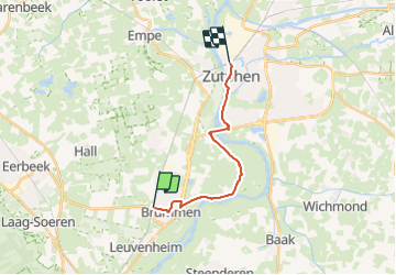
9,3 km | 10 km-effort
2h 16min
![](https://static1.geolcdn.com/siteimages/upload/files/16400158638029165_repeat_loop_refresh_sync_direction_icon.png)
Non
![Randonnée A pied Brummen - NL-Extension of NS-Wandeltocht Uiterwaarden van Cortenoever - Photo](https://media.geolcdn.com/t/375/260/ext.jpg?maxdim=2&url=https%3A%2F%2Fmedia.geolcdn.com%2Ff%2F93a9c4c6-7c78-4551-a6c2-3d1579e46df8.jpeg)
![A pied A pied](https://static1.geolcdn.com/sitytour/trail-icons/100.png)
NL-Extension of NS-Wandeltocht Uiterwaarden van Cortenoever
A pied
Facile
Brummen,
Gueldre,
Inconnu,
Pays-Bas
![](/images/other/stat-length.png)
3,1 km | 3,2 km-effort
44min
![](https://static1.geolcdn.com/siteimages/upload/files/16400158638029165_repeat_loop_refresh_sync_direction_icon.png)
Non
![Randonnée A pied Rheden - NS-wandeling Veluwezoom - Photo](https://media.geolcdn.com/t/375/260/ext.jpg?maxdim=2&url=https%3A%2F%2Fmedia.geolcdn.com%2Ff%2F46c1f15f-e1de-461e-a7a1-e79c7aff567f.jpeg)
![A pied A pied](https://static1.geolcdn.com/sitytour/trail-icons/100.png)
NS-wandeling Veluwezoom
A pied
Facile
Rheden,
Gueldre,
Inconnu,
Pays-Bas
![](/images/other/stat-length.png)
15,5 km | 18,9 km-effort
4h 17min
![](https://static1.geolcdn.com/siteimages/upload/files/16400158638029165_repeat_loop_refresh_sync_direction_icon.png)
Non
![Randonnée A pied Brummen - rode wandelroute Voorstonden 7 km - Photo](https://media.geolcdn.com/t/375/260/ext.jpg?maxdim=2&url=https%3A%2F%2Fmedia.geolcdn.com%2Ff%2F428d914c-4f41-4732-9114-8e7261a736a9.jpeg)
![A pied A pied](https://static1.geolcdn.com/sitytour/trail-icons/100.png)
rode wandelroute Voorstonden 7 km
A pied
Facile
Brummen,
Gueldre,
Inconnu,
Pays-Bas
![](/images/other/stat-length.png)
6,3 km | 7,3 km-effort
1h 39min
![](https://static1.geolcdn.com/siteimages/upload/files/16400158638029165_repeat_loop_refresh_sync_direction_icon.png)
Oui
![Randonnée A pied Brummen - Dwars door Gelderland (18) - Photo](https://media.geolcdn.com/t/375/260/ext.jpg?maxdim=2&url=https%3A%2F%2Fmedia.geolcdn.com%2Ff%2F10c78f16-8829-4f8a-8baa-3d107f22012b.jpeg)
![A pied A pied](https://static1.geolcdn.com/sitytour/trail-icons/100.png)
Dwars door Gelderland (18)
A pied
Facile
Brummen,
Gueldre,
Inconnu,
Pays-Bas
![](/images/other/stat-length.png)
7,6 km | 8,3 km-effort
1h 52min
![](https://static1.geolcdn.com/siteimages/upload/files/16400158638029165_repeat_loop_refresh_sync_direction_icon.png)
Non
![Randonnée A pied Brummen - Dwars door Gelderland (17) - Photo](https://media.geolcdn.com/t/375/260/ext.jpg?maxdim=2&url=https%3A%2F%2Fmedia.geolcdn.com%2Ff%2F5073ca41-17a8-411f-ab5c-9a92f3d474d4.jpeg)
![A pied A pied](https://static1.geolcdn.com/sitytour/trail-icons/100.png)
Dwars door Gelderland (17)
A pied
Facile
Brummen,
Gueldre,
Inconnu,
Pays-Bas
![](/images/other/stat-length.png)
6,2 km | 6,7 km-effort
1h 31min
![](https://static1.geolcdn.com/siteimages/upload/files/16400158638029165_repeat_loop_refresh_sync_direction_icon.png)
Non
![Randonnée Vélo Rheden - Gelderland - Vael Ouwetocht - Photo](https://media.geolcdn.com/t/375/260/ext.jpg?maxdim=2&url=https%3A%2F%2Fstatic1.geolcdn.com%2Fsiteimages%2Fupload%2Ffiles%2F1524743154velo.jpg)
![Vélo Vélo](https://static1.geolcdn.com/sitytour/trail-icons/200.png)
Gelderland - Vael Ouwetocht
Vélo
Très facile
Rheden,
Gueldre,
Inconnu,
Pays-Bas
![](/images/other/stat-length.png)
352 km | 390 km-effort
Inconnu
![](https://static1.geolcdn.com/siteimages/upload/files/16400158638029165_repeat_loop_refresh_sync_direction_icon.png)
Oui
![Randonnée Vélo Rheden - f-gelderland-vael-ouwe-2007 - Photo](https://media.geolcdn.com/t/375/260/ext.jpg?maxdim=2&url=https%3A%2F%2Fstatic1.geolcdn.com%2Fsiteimages%2Fupload%2Ffiles%2F1524743154velo.jpg)
![Vélo Vélo](https://static1.geolcdn.com/sitytour/trail-icons/200.png)
f-gelderland-vael-ouwe-2007
Vélo
Très facile
Rheden,
Gueldre,
Inconnu,
Pays-Bas
![](/images/other/stat-length.png)
155 km | 177 km-effort
Inconnu
![](https://static1.geolcdn.com/siteimages/upload/files/16400158638029165_repeat_loop_refresh_sync_direction_icon.png)
Oui
![Randonnée Vélo Rheden - f-gelderland-buitenom-brummen-route - Photo](https://media.geolcdn.com/t/375/260/ext.jpg?maxdim=2&url=https%3A%2F%2Fstatic1.geolcdn.com%2Fsiteimages%2Fupload%2Ffiles%2F1524743154velo.jpg)
![Vélo Vélo](https://static1.geolcdn.com/sitytour/trail-icons/200.png)
f-gelderland-buitenom-brummen-route
Vélo
Très facile
Rheden,
Gueldre,
Inconnu,
Pays-Bas
![](/images/other/stat-length.png)
35 km | 37 km-effort
Inconnu
![](https://static1.geolcdn.com/siteimages/upload/files/16400158638029165_repeat_loop_refresh_sync_direction_icon.png)
Oui