![](/images/other/stat-length.png)
![Randonnée A pied Lourinhã e Atalaia - Rota dos Dinossauros - Photo](https://media.geolcdn.com/t/1900/400/e4cdd5d0-9d97-4c20-8517-75e1b0e53b1a.jpeg&format=pjpeg&maxdim=2)
Rota dos Dinossauros
SityTrail - itinéraires balisés pédestres
Tous les sentiers balisés d’Europe GUIDE+
![Longueur](/images/other/stat-length.png)
![Altitude max](https://static1.geolcdn.com/siteimages/upload/files/1508320355ic_sort_altitude_max_24dp.png)
![Dénivelé positif](https://static1.geolcdn.com/siteimages/upload/files/1508320355ic_sort_den_pos_24dp.png)
![Km-Effort](/images/other/stat-length.png)
![Altitude min](https://static1.geolcdn.com/siteimages/upload/files/1508320355ic_sort_altitude_min_24dp.png)
![Dénivelé négatif](https://static1.geolcdn.com/siteimages/upload/files/1508320355ic_sort_den_neg_24dp.png)
![Boucle](https://static1.geolcdn.com/siteimages/upload/files/16400158638029165_repeat_loop_refresh_sync_direction_icon.png)
![A pied](https://static1.geolcdn.com/sitytour/trail-icons/100.png)
56m
Difficulté : Facile
![Scannez ce code QR pour ouvrir la randonnée dans l'application SityTrail](https://capi.geolives.com/qq0zvz2zws4bq2lad0pu/sitytour/trails/3109939/qr.png?size=200)
Application GPS de randonnée GRATUITE
À propos
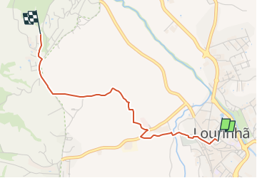
Randonnée A pied de 3 km à découvrir à Centre, Lisbonne, Lourinhã e Atalaia. Cette randonnée est proposée par SityTrail - itinéraires balisés pédestres.
Description
Randonnée créée par http://www.cm-lourinha.pt.
O PR1 "Rota dos Dinossauros" inicia-se junto ao Museu da Lourinhã, que integra uma valiosa ala de paleontologia, terminando no Forte Paimogo. Ao longo de 9.900 metros, o caminhante pode visitar outros pontos de interesse histórico, como o Convento de San
Symbole: Red over Yellow
Localisation
Commentaires
Randonnées à proximité
![Randonnée A pied A dos Cunhados e Maceira - Pelos Caminhos da Batalha do Vimeiro - Photo](https://media.geolcdn.com/t/375/260/152a277d-7cdc-4c59-9d15-852398903aee.jpeg&format=jpg&maxdim=2)
![A pied A pied](https://static1.geolcdn.com/sitytour/trail-icons/100.png)
A pied
![](/images/other/stat-length.png)
![](https://static1.geolcdn.com/siteimages/upload/files/16400158638029165_repeat_loop_refresh_sync_direction_icon.png)
![Randonnée A pied Roliça - O Caminho da Roliça - Photo](https://media.geolcdn.com/t/375/260/9ffe6a88-ae89-435f-83c0-fb49a706944e.jpeg&format=jpg&maxdim=2)
![A pied A pied](https://static1.geolcdn.com/sitytour/trail-icons/100.png)
A pied
![](/images/other/stat-length.png)
![](https://static1.geolcdn.com/siteimages/upload/files/16400158638029165_repeat_loop_refresh_sync_direction_icon.png)
![Randonnée A pied A dos Cunhados e Maceira - Rota do Atlântico - Photo](https://media.geolcdn.com/t/375/260/4c9a3719-f01b-44c7-9392-a1af5d775536.jpeg&format=jpg&maxdim=2)
![A pied A pied](https://static1.geolcdn.com/sitytour/trail-icons/100.png)
A pied
![](/images/other/stat-length.png)
![](https://static1.geolcdn.com/siteimages/upload/files/16400158638029165_repeat_loop_refresh_sync_direction_icon.png)
![Randonnée A pied Maxial e Monte Redondo - Rota das Lapas - Photo](https://media.geolcdn.com/t/375/260/0f74451f-f338-41a2-87ea-607f685e0dba.jpeg&format=jpg&maxdim=2)
![A pied A pied](https://static1.geolcdn.com/sitytour/trail-icons/100.png)
A pied
![](/images/other/stat-length.png)
![](https://static1.geolcdn.com/siteimages/upload/files/16400158638029165_repeat_loop_refresh_sync_direction_icon.png)
![Randonnée A pied Santa Maria, São Pedro e Matacães - Rota do Castro do Zambujal - Photo](https://media.geolcdn.com/t/375/260/b6196e00-b6e7-4ff7-a6d0-23b1a8a543a8.jpeg&format=jpg&maxdim=2)
![A pied A pied](https://static1.geolcdn.com/sitytour/trail-icons/100.png)
A pied
![](/images/other/stat-length.png)
![](https://static1.geolcdn.com/siteimages/upload/files/16400158638029165_repeat_loop_refresh_sync_direction_icon.png)
![Randonnée A pied Carvoeira e Carmões - Rota da Luz - Photo](https://media.geolcdn.com/t/375/260/ext.jpg?maxdim=2&url=https%3A%2F%2Fstatic1.geolcdn.com%2Fsiteimages%2Fupload%2Ffiles%2F1545311037marcheuse_200dpi.jpg)
![A pied A pied](https://static1.geolcdn.com/sitytour/trail-icons/100.png)
A pied
![](/images/other/stat-length.png)
![](https://static1.geolcdn.com/siteimages/upload/files/16400158638029165_repeat_loop_refresh_sync_direction_icon.png)
![Randonnée Trail Carvalhal - Obidos trail run - Photo](https://media.geolcdn.com/t/375/260/ext.jpg?maxdim=2&url=https%3A%2F%2Fstatic1.geolcdn.com%2Fsiteimages%2Fupload%2Ffiles%2F1524743154running.jpg)
![Trail Trail](https://static1.geolcdn.com/sitytour/trail-icons/104.png)
![Randonnée Marche Atouguia da Baleia - Barrage De Sao Doningo - Photo](https://media.geolcdn.com/t/375/260/ext.jpg?maxdim=2&url=https%3A%2F%2Fstatic1.geolcdn.com%2Fsiteimages%2Fupload%2Ffiles%2F1553511878bg_sport_marche.png)
![Marche Marche](https://static1.geolcdn.com/sitytour/trail-icons/101.png)
Marche
![](/images/other/stat-length.png)
![](https://static1.geolcdn.com/siteimages/upload/files/16400158638029165_repeat_loop_refresh_sync_direction_icon.png)
![Randonnée Marche - Berlengas - Photo](https://media.geolcdn.com/t/375/260/ext.jpg?maxdim=2&url=https%3A%2F%2Fstatic1.geolcdn.com%2Fsiteimages%2Fupload%2Ffiles%2F1553511878bg_sport_marche.png)
![Marche Marche](https://static1.geolcdn.com/sitytour/trail-icons/101.png)