![](/images/other/stat-length.png)
![Randonnée A pied Bronckhorst - De Wildenborch Route - Photo](https://media.geolcdn.com/t/1900/400/03237455-549e-486d-9ec0-9a1319ae6ede.jpeg&format=pjpeg&maxdim=2)
De Wildenborch Route
SityTrail - itinéraires balisés pédestres
Tous les sentiers balisés d’Europe GUIDE+
![Longueur](/images/other/stat-length.png)
![Altitude max](https://static1.geolcdn.com/siteimages/upload/files/1508320355ic_sort_altitude_max_24dp.png)
![Dénivelé positif](https://static1.geolcdn.com/siteimages/upload/files/1508320355ic_sort_den_pos_24dp.png)
![Km-Effort](/images/other/stat-length.png)
![Altitude min](https://static1.geolcdn.com/siteimages/upload/files/1508320355ic_sort_altitude_min_24dp.png)
![Dénivelé négatif](https://static1.geolcdn.com/siteimages/upload/files/1508320355ic_sort_den_neg_24dp.png)
![Boucle](https://static1.geolcdn.com/siteimages/upload/files/16400158638029165_repeat_loop_refresh_sync_direction_icon.png)
![A pied](https://static1.geolcdn.com/sitytour/trail-icons/100.png)
1h35
Difficulté : Facile
![Scannez ce code QR pour ouvrir la randonnée dans l'application SityTrail](https://capi.geolives.com/qq0zvz2zws4bq2lad0pu/sitytour/trails/3109921/qr.png?size=200)
Application GPS de randonnée GRATUITE
À propos
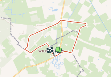
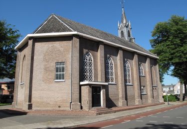
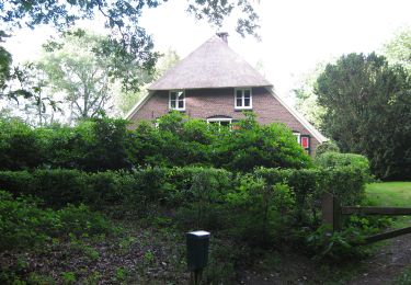
Randonnée A pied de 6,5 km à découvrir à Gueldre, Inconnu, Bronckhorst. Cette randonnée est proposée par SityTrail - itinéraires balisés pédestres.
Description
Kom wandelen in het afwisselende decor van de Achterhoek! Ontdek de mooiste plekken met het handige wandelnetwerk en de prachtige wandelroutes.
Site web: https://www.achterhoek.nl/wandelen
Localisation
Commentaires
Randonnées à proximité
![Randonnée A pied Lochem - Rondje Velhorst - Photo](https://media.geolcdn.com/t/375/260/55919bbd-4040-4eb2-9b13-521e584d1f27.jpeg&format=jpg&maxdim=2)
![A pied A pied](https://static1.geolcdn.com/sitytour/trail-icons/100.png)
![Randonnée A pied Bronckhorst - Hackfortse Enkroute - Photo](https://media.geolcdn.com/t/375/260/40f9f402-e097-413d-87d3-c98c81a339fc.jpeg&format=jpg&maxdim=2)
![A pied A pied](https://static1.geolcdn.com/sitytour/trail-icons/100.png)
A pied
![](/images/other/stat-length.png)
![](https://static1.geolcdn.com/siteimages/upload/files/16400158638029165_repeat_loop_refresh_sync_direction_icon.png)
![Randonnée A pied Lochem - Lochemse Berg Route - Photo](https://media.geolcdn.com/t/375/260/0b3bf5ef-5885-40ac-820f-254b98fec905.jpeg&format=jpg&maxdim=2)
![A pied A pied](https://static1.geolcdn.com/sitytour/trail-icons/100.png)
A pied
![](/images/other/stat-length.png)
![](https://static1.geolcdn.com/siteimages/upload/files/16400158638029165_repeat_loop_refresh_sync_direction_icon.png)
![Randonnée A pied Berkelland - Liefdespad - Photo](https://media.geolcdn.com/t/375/260/ab5b63fd-509a-443f-b3b0-8fd854ce338b.jpeg&format=jpg&maxdim=2)
![A pied A pied](https://static1.geolcdn.com/sitytour/trail-icons/100.png)
![Randonnée A pied Lochem - Rondje Barchem - Photo](https://media.geolcdn.com/t/375/260/7fc336cf-e104-491e-940c-7899e0be83de.jpeg&format=jpg&maxdim=2)
![A pied A pied](https://static1.geolcdn.com/sitytour/trail-icons/100.png)
A pied
![](/images/other/stat-length.png)
![](https://static1.geolcdn.com/siteimages/upload/files/16400158638029165_repeat_loop_refresh_sync_direction_icon.png)
![Randonnée A pied Lochem - Barchems Wandel Ommetje - Photo](https://media.geolcdn.com/t/375/260/7fc336cf-e104-491e-940c-7899e0be83de.jpeg&format=jpg&maxdim=2)
![A pied A pied](https://static1.geolcdn.com/sitytour/trail-icons/100.png)
A pied
![](/images/other/stat-length.png)
![](https://static1.geolcdn.com/siteimages/upload/files/16400158638029165_repeat_loop_refresh_sync_direction_icon.png)
![Randonnée A pied Lochem - De Boschheurne Route - Photo](https://media.geolcdn.com/t/375/260/7fc336cf-e104-491e-940c-7899e0be83de.jpeg&format=jpg&maxdim=2)
![A pied A pied](https://static1.geolcdn.com/sitytour/trail-icons/100.png)
A pied
![](/images/other/stat-length.png)
![](https://static1.geolcdn.com/siteimages/upload/files/16400158638029165_repeat_loop_refresh_sync_direction_icon.png)
![Randonnée A pied Lochem - Staring Route - Photo](https://media.geolcdn.com/t/375/260/b41bc411-eaa0-4edc-9dc8-c4d9bb11682f.jpeg&format=jpg&maxdim=2)
![A pied A pied](https://static1.geolcdn.com/sitytour/trail-icons/100.png)
![Randonnée A pied Bronckhorst - Groene Wissel Vorden - Photo](https://media.geolcdn.com/t/375/260/8a04b06c-899e-4d67-8753-414f94f77f6b.jpeg&format=jpg&maxdim=2)
![A pied A pied](https://static1.geolcdn.com/sitytour/trail-icons/100.png)
A pied
![](/images/other/stat-length.png)
![](https://static1.geolcdn.com/siteimages/upload/files/16400158638029165_repeat_loop_refresh_sync_direction_icon.png)