![](/images/other/stat-length.png)
![Randonnée A pied Arnhem - NS-wandeling Warnsborn - Photo](https://media.geolcdn.com/t/1900/400/68894f33-5963-49f9-a97e-666a755bcf4a.jpeg&format=pjpeg&maxdim=2)
NS-wandeling Warnsborn
SityTrail - itinéraires balisés pédestres
Tous les sentiers balisés d’Europe GUIDE+
![Longueur](/images/other/stat-length.png)
Longueur
19,7 km
![Altitude max](https://static1.geolcdn.com/siteimages/upload/files/1508320355ic_sort_altitude_max_24dp.png)
Altitude max
82 m
![Dénivelé positif](https://static1.geolcdn.com/siteimages/upload/files/1508320355ic_sort_den_pos_24dp.png)
Dénivelé positif
226 m
![Km-Effort](/images/other/stat-length.png)
Km-Effort
23 km
![Altitude min](https://static1.geolcdn.com/siteimages/upload/files/1508320355ic_sort_altitude_min_24dp.png)
Altitude min
18 m
![Dénivelé négatif](https://static1.geolcdn.com/siteimages/upload/files/1508320355ic_sort_den_neg_24dp.png)
Dénivelé négatif
229 m
![Boucle](https://static1.geolcdn.com/siteimages/upload/files/16400158638029165_repeat_loop_refresh_sync_direction_icon.png)
Boucle
Non
Balise
Date de création :
2022-02-14 15:03:18.263
Dernière modification :
2022-02-14 15:03:18.263
![A pied](https://static1.geolcdn.com/sitytour/trail-icons/100.png)
5h09
Difficulté : Moyen
![Scannez ce code QR pour ouvrir la randonnée dans l'application SityTrail](https://capi.geolives.com/qq0zvz2zws4bq2lad0pu/sitytour/trails/3109520/qr.png?size=200)
Application GPS de randonnée GRATUITE
À propos
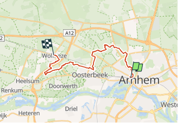
Randonnée A pied de 19,7 km à découvrir à Gueldre, Inconnu, Arnhem. Cette randonnée est proposée par SityTrail - itinéraires balisés pédestres.
Description
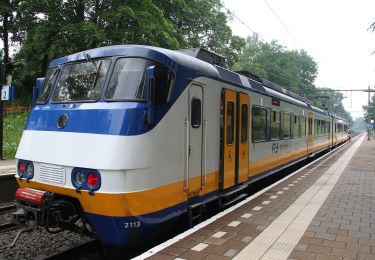
Voor wie houdt van een boswandeling met de nodige afwisseling is de NS-wandeling Warnsborn een goede optie.
Site web: https://www.ns.nl/dagje-uit/wandelen/warnsborn.html
Localisation
Pays :
Pays-Bas
Région :
Gueldre
Département/Province :
Inconnu
Commune :
Arnhem
Localité :
Unknown
Départ:(Dec)
Départ:(UTM)
699066 ; 5763410 (31U) N.
Commentaires
Randonnées à proximité
![Randonnée A pied Renkum - NS-wandeling Hemelse Berg - Photo](https://media.geolcdn.com/t/375/260/93ca447f-42ea-4496-8d0a-71e3f7e5f83d.jpeg&format=jpg&maxdim=2)
![A pied A pied](https://static1.geolcdn.com/sitytour/trail-icons/100.png)
NS-wandeling Hemelse Berg
A pied
Facile
Renkum,
Gueldre,
Inconnu,
Pays-Bas
![](/images/other/stat-length.png)
15 km | 17,5 km-effort
3h 58min
![](https://static1.geolcdn.com/siteimages/upload/files/16400158638029165_repeat_loop_refresh_sync_direction_icon.png)
Non
![Randonnée A pied Arnhem - Groene Wissel: Arnhem - Photo](https://media.geolcdn.com/t/375/260/ac0c51f6-2192-4fb5-94e9-c2127ec0716b.jpeg&format=jpg&maxdim=2)
![A pied A pied](https://static1.geolcdn.com/sitytour/trail-icons/100.png)
Groene Wissel: Arnhem
A pied
Facile
Arnhem,
Gueldre,
Inconnu,
Pays-Bas
![](/images/other/stat-length.png)
9,4 km | 11,5 km-effort
2h 37min
![](https://static1.geolcdn.com/siteimages/upload/files/16400158638029165_repeat_loop_refresh_sync_direction_icon.png)
Non
![Randonnée A pied Renkum - Groene Wissel: Oosterbeek 066 - Photo](https://media.geolcdn.com/t/375/260/81498446-d79c-472a-b0ce-1a39418acc87.jpeg&format=jpg&maxdim=2)
![A pied A pied](https://static1.geolcdn.com/sitytour/trail-icons/100.png)
Groene Wissel: Oosterbeek 066
A pied
Facile
Renkum,
Gueldre,
Inconnu,
Pays-Bas
![](/images/other/stat-length.png)
16,9 km | 19,8 km-effort
4h 29min
![](https://static1.geolcdn.com/siteimages/upload/files/16400158638029165_repeat_loop_refresh_sync_direction_icon.png)
Oui
![Randonnée A pied Arnhem - Westereinde - Photo](https://media.geolcdn.com/t/375/260/45f9c7f4-aa5d-4ddc-8b51-0461d176d59b.jpeg&format=jpg&maxdim=2)
![A pied A pied](https://static1.geolcdn.com/sitytour/trail-icons/100.png)
![Randonnée A pied Arnhem - Warnsborn - Photo](https://media.geolcdn.com/t/375/260/b5ce95be-17b5-43a6-a5c0-b58c49c7b2a3.jpeg&format=jpg&maxdim=2)
![A pied A pied](https://static1.geolcdn.com/sitytour/trail-icons/100.png)
![Randonnée A pied Renkum - Lichtenbeek - Photo](https://media.geolcdn.com/t/375/260/7c595dc5-a44c-4afa-8a88-6faad09fafd2.jpeg&format=jpg&maxdim=2)
![A pied A pied](https://static1.geolcdn.com/sitytour/trail-icons/100.png)
![Randonnée A pied Arnhem - Mariëndaal - Photo](https://media.geolcdn.com/t/375/260/0f2e84b6-deec-4ab5-a9dc-412b4f673362.jpeg&format=jpg&maxdim=2)
![A pied A pied](https://static1.geolcdn.com/sitytour/trail-icons/100.png)
![Randonnée A pied Arnhem - Wandelen door park Zypendaal en Sonsbeek - Photo](https://media.geolcdn.com/t/375/260/12a45e37-cede-4d21-abe3-28d2d0f4ec16.jpeg&format=jpg&maxdim=2)
![A pied A pied](https://static1.geolcdn.com/sitytour/trail-icons/100.png)
Wandelen door park Zypendaal en Sonsbeek
A pied
Facile
Arnhem,
Gueldre,
Inconnu,
Pays-Bas
![](/images/other/stat-length.png)
3,7 km | 4,4 km-effort
59min
![](https://static1.geolcdn.com/siteimages/upload/files/16400158638029165_repeat_loop_refresh_sync_direction_icon.png)
Oui
![Randonnée A pied Rozendaal - Dwars door Gelderland (14) - Photo](https://media.geolcdn.com/t/375/260/1a52ba51-82f3-485d-b22f-dae092695350.jpeg&format=jpg&maxdim=2)
![A pied A pied](https://static1.geolcdn.com/sitytour/trail-icons/100.png)
Dwars door Gelderland (14)
A pied
Facile
Rozendaal,
Gueldre,
Inconnu,
Pays-Bas
![](/images/other/stat-length.png)
9,2 km | 11,7 km-effort
2h 39min
![](https://static1.geolcdn.com/siteimages/upload/files/16400158638029165_repeat_loop_refresh_sync_direction_icon.png)
Non