![](/images/other/stat-length.png)
![Randonnée A pied Zevenaar - Rijnstrangenpad - Photo](https://media.geolcdn.com/t/1900/400/991f4728-fd23-4eff-8387-ce53e7cf18e5.jpeg&format=pjpeg&maxdim=2)
Rijnstrangenpad
SityTrail - itinéraires balisés pédestres
Tous les sentiers balisés d’Europe GUIDE+
![Longueur](/images/other/stat-length.png)
Longueur
14,3 km
![Altitude max](https://static1.geolcdn.com/siteimages/upload/files/1508320355ic_sort_altitude_max_24dp.png)
Altitude max
20 m
![Dénivelé positif](https://static1.geolcdn.com/siteimages/upload/files/1508320355ic_sort_den_pos_24dp.png)
Dénivelé positif
52 m
![Km-Effort](/images/other/stat-length.png)
Km-Effort
15 km
![Altitude min](https://static1.geolcdn.com/siteimages/upload/files/1508320355ic_sort_altitude_min_24dp.png)
Altitude min
8 m
![Dénivelé négatif](https://static1.geolcdn.com/siteimages/upload/files/1508320355ic_sort_den_neg_24dp.png)
Dénivelé négatif
52 m
![Boucle](https://static1.geolcdn.com/siteimages/upload/files/16400158638029165_repeat_loop_refresh_sync_direction_icon.png)
Boucle
Oui
Balise
Date de création :
2022-02-14 14:48:29.654
Dernière modification :
2022-02-14 14:48:29.654
![A pied](https://static1.geolcdn.com/sitytour/trail-icons/100.png)
3h24
Difficulté : Facile
![Scannez ce code QR pour ouvrir la randonnée dans l'application SityTrail](https://capi.geolives.com/qq0zvz2zws4bq2lad0pu/sitytour/trails/3109292/qr.png?size=200)
Application GPS de randonnée GRATUITE
À propos
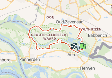
Randonnée A pied de 14,3 km à découvrir à Gueldre, Inconnu, Zevenaar. Cette randonnée est proposée par SityTrail - itinéraires balisés pédestres.
Description
Randonnée créée par https://klompenpaden.nl.
Symbole: paarse markering in de vorm van een klomp
Site web: https://klompenpaden.nl/klompenpad/rijnstrangenpad/
Localisation
Pays :
Pays-Bas
Région :
Gueldre
Département/Province :
Inconnu
Commune :
Zevenaar
Localité :
Unknown
Départ:(Dec)
Départ:(UTM)
299858 ; 5753327 (32U) N.
Commentaires
Randonnées à proximité
![Randonnée A pied Montferland - Liemers Knooppad 6 - Photo](https://media.geolcdn.com/t/375/260/dev_b2ad50d1-04eb-423f-928a-8ae9dca5c1cf.jpeg&format=jpg&maxdim=2)
![A pied A pied](https://static1.geolcdn.com/sitytour/trail-icons/100.png)
Liemers Knooppad 6
A pied
Facile
Montferland,
Gueldre,
Inconnu,
Pays-Bas
![](/images/other/stat-length.png)
9,4 km | 10,4 km-effort
2h 21min
![](https://static1.geolcdn.com/siteimages/upload/files/16400158638029165_repeat_loop_refresh_sync_direction_icon.png)
Non
![Randonnée Vélo Berg en Dal - Gelderland - Millingen Aan De Rijn - Photo](https://media.geolcdn.com/t/375/260/ext.jpg?maxdim=2&url=https%3A%2F%2Fstatic1.geolcdn.com%2Fsiteimages%2Fupload%2Ffiles%2F1524743154velo.jpg)
![Vélo Vélo](https://static1.geolcdn.com/sitytour/trail-icons/200.png)
Gelderland - Millingen Aan De Rijn
Vélo
Très facile
Berg en Dal,
Gueldre,
Inconnu,
Pays-Bas
![](/images/other/stat-length.png)
31 km | 33 km-effort
Inconnu
![](https://static1.geolcdn.com/siteimages/upload/files/16400158638029165_repeat_loop_refresh_sync_direction_icon.png)
Oui
![Randonnée Vélo Lingewaard - f-gelderland-linge - Photo](https://media.geolcdn.com/t/375/260/ext.jpg?maxdim=2&url=https%3A%2F%2Fstatic1.geolcdn.com%2Fsiteimages%2Fupload%2Ffiles%2F1524743154velo.jpg)
![Vélo Vélo](https://static1.geolcdn.com/sitytour/trail-icons/200.png)
f-gelderland-linge
Vélo
Très facile
Lingewaard,
Gueldre,
Inconnu,
Pays-Bas
![](/images/other/stat-length.png)
96 km | 101 km-effort
Inconnu
![](https://static1.geolcdn.com/siteimages/upload/files/16400158638029165_repeat_loop_refresh_sync_direction_icon.png)
Non
![Randonnée Vélo Zevenaar - f-gelderland-grenslandroute - Photo](https://media.geolcdn.com/t/375/260/ext.jpg?maxdim=2&url=https%3A%2F%2Fstatic1.geolcdn.com%2Fsiteimages%2Fupload%2Ffiles%2F1524743154velo.jpg)
![Vélo Vélo](https://static1.geolcdn.com/sitytour/trail-icons/200.png)
f-gelderland-grenslandroute
Vélo
Très facile
Zevenaar,
Gueldre,
Inconnu,
Pays-Bas
![](/images/other/stat-length.png)
38 km | 42 km-effort
Inconnu
![](https://static1.geolcdn.com/siteimages/upload/files/16400158638029165_repeat_loop_refresh_sync_direction_icon.png)
Non
![Randonnée Vélo Zevenaar - f-gelderland-fietstocht-tolkamer-emmerich-millingen-ad-rijn - Photo](https://media.geolcdn.com/t/375/260/ext.jpg?maxdim=2&url=https%3A%2F%2Fstatic1.geolcdn.com%2Fsiteimages%2Fupload%2Ffiles%2F1524743154velo.jpg)
![Vélo Vélo](https://static1.geolcdn.com/sitytour/trail-icons/200.png)
f-gelderland-fietstocht-tolkamer-emmerich-millingen-ad-rijn
Vélo
Très facile
Zevenaar,
Gueldre,
Inconnu,
Pays-Bas
![](/images/other/stat-length.png)
34 km | 36 km-effort
Inconnu
![](https://static1.geolcdn.com/siteimages/upload/files/16400158638029165_repeat_loop_refresh_sync_direction_icon.png)
Oui
![Randonnée Marche Zevenaar - w-gelderland-rijnstrangenroute - Photo](https://media.geolcdn.com/t/375/260/ext.jpg?maxdim=2&url=https%3A%2F%2Fstatic1.geolcdn.com%2Fsiteimages%2Fupload%2Ffiles%2F1553511878bg_sport_marche.png)
![Marche Marche](https://static1.geolcdn.com/sitytour/trail-icons/101.png)
w-gelderland-rijnstrangenroute
Marche
Très facile
Zevenaar,
Gueldre,
Inconnu,
Pays-Bas
![](/images/other/stat-length.png)
15,1 km | 15,9 km-effort
Inconnu
![](https://static1.geolcdn.com/siteimages/upload/files/16400158638029165_repeat_loop_refresh_sync_direction_icon.png)
Non
![Randonnée Marche Zevenaar - w-gelderland-lobith-tolkamer - Photo](https://media.geolcdn.com/t/375/260/ext.jpg?maxdim=2&url=https%3A%2F%2Fstatic1.geolcdn.com%2Fsiteimages%2Fupload%2Ffiles%2F1553511878bg_sport_marche.png)
![Marche Marche](https://static1.geolcdn.com/sitytour/trail-icons/101.png)
w-gelderland-lobith-tolkamer
Marche
Très facile
Zevenaar,
Gueldre,
Inconnu,
Pays-Bas
![](/images/other/stat-length.png)
12,1 km | 12,7 km-effort
Inconnu
![](https://static1.geolcdn.com/siteimages/upload/files/16400158638029165_repeat_loop_refresh_sync_direction_icon.png)
Oui
![Randonnée Marche Zevenaar - w-gelderland-het-hof-aerdt - Photo](https://media.geolcdn.com/t/375/260/ext.jpg?maxdim=2&url=https%3A%2F%2Fstatic1.geolcdn.com%2Fsiteimages%2Fupload%2Ffiles%2F1553511878bg_sport_marche.png)
![Marche Marche](https://static1.geolcdn.com/sitytour/trail-icons/101.png)
w-gelderland-het-hof-aerdt
Marche
Très facile
Zevenaar,
Gueldre,
Inconnu,
Pays-Bas
![](/images/other/stat-length.png)
12,5 km | 13,1 km-effort
Inconnu
![](https://static1.geolcdn.com/siteimages/upload/files/16400158638029165_repeat_loop_refresh_sync_direction_icon.png)
Oui
![Randonnée Marche Emmerich am Rhein - w-gelderland-elten-babberich - Photo](https://media.geolcdn.com/t/375/260/ext.jpg?maxdim=2&url=https%3A%2F%2Fstatic1.geolcdn.com%2Fsiteimages%2Fupload%2Ffiles%2F1553511878bg_sport_marche.png)
![Marche Marche](https://static1.geolcdn.com/sitytour/trail-icons/101.png)
w-gelderland-elten-babberich
Marche
Très facile
Emmerich am Rhein,
Rhénanie-du-Nord-Westphalie,
Kreis Kleve,
Allemagne
![](/images/other/stat-length.png)
13,6 km | 14,6 km-effort
Inconnu
![](https://static1.geolcdn.com/siteimages/upload/files/16400158638029165_repeat_loop_refresh_sync_direction_icon.png)
Oui