![](/images/other/stat-length.png)
![Randonnée A pied Texel - Sommelpaadje - Photo](https://media.geolcdn.com/t/1900/400/19a915fb-0534-4f3d-8815-4637ba0cb781.jpeg&format=pjpeg&maxdim=2)
Sommelpaadje
SityTrail - itinéraires balisés pédestres
Tous les sentiers balisés d’Europe GUIDE+
![Longueur](/images/other/stat-length.png)
Longueur
4,9 km
![Altitude max](https://static1.geolcdn.com/siteimages/upload/files/1508320355ic_sort_altitude_max_24dp.png)
Altitude max
4 m
![Dénivelé positif](https://static1.geolcdn.com/siteimages/upload/files/1508320355ic_sort_den_pos_24dp.png)
Dénivelé positif
16 m
![Km-Effort](/images/other/stat-length.png)
Km-Effort
5,1 km
![Altitude min](https://static1.geolcdn.com/siteimages/upload/files/1508320355ic_sort_altitude_min_24dp.png)
Altitude min
-4 m
![Dénivelé négatif](https://static1.geolcdn.com/siteimages/upload/files/1508320355ic_sort_den_neg_24dp.png)
Dénivelé négatif
16 m
![Boucle](https://static1.geolcdn.com/siteimages/upload/files/16400158638029165_repeat_loop_refresh_sync_direction_icon.png)
Boucle
Oui
Balise
Date de création :
2022-02-14 14:38:55.929
Dernière modification :
2022-02-14 14:38:55.929
![A pied](https://static1.geolcdn.com/sitytour/trail-icons/100.png)
1h09
Difficulté : Facile
![Scannez ce code QR pour ouvrir la randonnée dans l'application SityTrail](https://capi.geolives.com/qq0zvz2zws4bq2lad0pu/sitytour/trails/3109027/qr.png?size=200)
Application GPS de randonnée GRATUITE
À propos
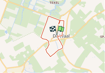
Randonnée A pied de 4,9 km à découvrir à Hollande-Septentrionale, Inconnu, Texel. Cette randonnée est proposée par SityTrail - itinéraires balisés pédestres.
Description
Randonnée créée par de lieuwe.
Symbole: green shoeprint on lightgreen circle
Site web: https://www.delieuw.nl/
Localisation
Pays :
Pays-Bas
Région :
Hollande-Septentrionale
Département/Province :
Inconnu
Commune :
Texel
Localité :
Unknown
Départ:(Dec)
Départ:(UTM)
621955 ; 5881930 (31U) N.
Commentaires
Randonnées à proximité
![Randonnée A pied Texel - Natuurpad Alloo - Photo](https://media.geolcdn.com/t/375/260/2495b563-29bd-4f91-9fd8-544019ca29b0.jpeg&format=jpg&maxdim=2)
![A pied A pied](https://static1.geolcdn.com/sitytour/trail-icons/100.png)
Natuurpad Alloo
A pied
Facile
Texel,
Hollande-Septentrionale,
Inconnu,
Pays-Bas
![](/images/other/stat-length.png)
4,5 km | 4,9 km-effort
1h 7min
![](https://static1.geolcdn.com/siteimages/upload/files/16400158638029165_repeat_loop_refresh_sync_direction_icon.png)
Oui
![Randonnée Moteur Texel - a-nholland-rondje-texel - Photo](https://media.geolcdn.com/t/375/260/ext.jpg?maxdim=2&url=https%3A%2F%2Fstatic1.geolcdn.com%2Fsiteimages%2Fupload%2Ffiles%2F15247431544x4.jpg)
![Moteur Moteur](https://static1.geolcdn.com/sitytour/trail-icons/400.png)
a-nholland-rondje-texel
Moteur
Très facile
Texel,
Hollande-Septentrionale,
Inconnu,
Pays-Bas
![](/images/other/stat-length.png)
89 km | 93 km-effort
Inconnu
![](https://static1.geolcdn.com/siteimages/upload/files/16400158638029165_repeat_loop_refresh_sync_direction_icon.png)
Oui
![Randonnée Vélo Texel - Noord-Holland - Texel Oostroute - Photo](https://media.geolcdn.com/t/375/260/ext.jpg?maxdim=2&url=https%3A%2F%2Fstatic1.geolcdn.com%2Fsiteimages%2Fupload%2Ffiles%2F1524743154velo.jpg)
![Vélo Vélo](https://static1.geolcdn.com/sitytour/trail-icons/200.png)
Noord-Holland - Texel Oostroute
Vélo
Très facile
Texel,
Hollande-Septentrionale,
Inconnu,
Pays-Bas
![](/images/other/stat-length.png)
31 km | 32 km-effort
Inconnu
![](https://static1.geolcdn.com/siteimages/upload/files/16400158638029165_repeat_loop_refresh_sync_direction_icon.png)
Oui
![Randonnée Vélo Texel - Noord-Holland - Fietstocht Texel Noord - Photo](https://media.geolcdn.com/t/375/260/ext.jpg?maxdim=2&url=https%3A%2F%2Fstatic1.geolcdn.com%2Fsiteimages%2Fupload%2Ffiles%2F1524743154velo.jpg)
![Vélo Vélo](https://static1.geolcdn.com/sitytour/trail-icons/200.png)
Noord-Holland - Fietstocht Texel Noord
Vélo
Très facile
Texel,
Hollande-Septentrionale,
Inconnu,
Pays-Bas
![](/images/other/stat-length.png)
42 km | 43 km-effort
Inconnu
![](https://static1.geolcdn.com/siteimages/upload/files/16400158638029165_repeat_loop_refresh_sync_direction_icon.png)
Oui
![Randonnée Vélo Texel - Noord-Holland - Fietsroute Texel - Photo](https://media.geolcdn.com/t/375/260/ext.jpg?maxdim=2&url=https%3A%2F%2Fstatic1.geolcdn.com%2Fsiteimages%2Fupload%2Ffiles%2F1524743154velo.jpg)
![Vélo Vélo](https://static1.geolcdn.com/sitytour/trail-icons/200.png)
Noord-Holland - Fietsroute Texel
Vélo
Très facile
Texel,
Hollande-Septentrionale,
Inconnu,
Pays-Bas
![](/images/other/stat-length.png)
33 km | 34 km-effort
Inconnu
![](https://static1.geolcdn.com/siteimages/upload/files/16400158638029165_repeat_loop_refresh_sync_direction_icon.png)
Oui
![Randonnée Vélo Texel - f-nholland-rondje-texel - Photo](https://media.geolcdn.com/t/375/260/ext.jpg?maxdim=2&url=https%3A%2F%2Fstatic1.geolcdn.com%2Fsiteimages%2Fupload%2Ffiles%2F1524743154velo.jpg)
![Vélo Vélo](https://static1.geolcdn.com/sitytour/trail-icons/200.png)
f-nholland-rondje-texel
Vélo
Très facile
Texel,
Hollande-Septentrionale,
Inconnu,
Pays-Bas
![](/images/other/stat-length.png)
39 km | 40 km-effort
Inconnu
![](https://static1.geolcdn.com/siteimages/upload/files/16400158638029165_repeat_loop_refresh_sync_direction_icon.png)
Non
![Randonnée Marche Texel - w-nholland-wandeling-door-de-slufter-en-de-muy - Photo](https://media.geolcdn.com/t/375/260/ext.jpg?maxdim=2&url=https%3A%2F%2Fstatic1.geolcdn.com%2Fsiteimages%2Fupload%2Ffiles%2F1553511878bg_sport_marche.png)
![Marche Marche](https://static1.geolcdn.com/sitytour/trail-icons/101.png)
w-nholland-wandeling-door-de-slufter-en-de-muy
Marche
Très facile
Texel,
Hollande-Septentrionale,
Inconnu,
Pays-Bas
![](/images/other/stat-length.png)
11,3 km | 11,9 km-effort
Inconnu
![](https://static1.geolcdn.com/siteimages/upload/files/16400158638029165_repeat_loop_refresh_sync_direction_icon.png)
Oui
![Randonnée Marche nordique Texel - 2011-12-23 Texel 3 - Photo](https://media.geolcdn.com/t/375/260/ext.jpg?maxdim=2&url=https%3A%2F%2Fstatic1.geolcdn.com%2Fsiteimages%2Fupload%2Ffiles%2F1545311037marcheuse_200dpi.jpg)
![Marche nordique Marche nordique](https://static1.geolcdn.com/sitytour/trail-icons/102.png)
2011-12-23 Texel 3
Marche nordique
Très facile
Texel,
Hollande-Septentrionale,
Inconnu,
Pays-Bas
![](/images/other/stat-length.png)
10,5 km | 11 km-effort
2h 41min
![](https://static1.geolcdn.com/siteimages/upload/files/16400158638029165_repeat_loop_refresh_sync_direction_icon.png)
Oui
![Randonnée Marche nordique Texel - 2011-12-22 Texel 2 - Photo](https://media.geolcdn.com/t/375/260/ext.jpg?maxdim=2&url=https%3A%2F%2Fstatic1.geolcdn.com%2Fsiteimages%2Fupload%2Ffiles%2F1545311037marcheuse_200dpi.jpg)
![Marche nordique Marche nordique](https://static1.geolcdn.com/sitytour/trail-icons/102.png)
2011-12-22 Texel 2
Marche nordique
Très facile
Texel,
Hollande-Septentrionale,
Inconnu,
Pays-Bas
![](/images/other/stat-length.png)
6,3 km | 6,6 km-effort
1h 26min
![](https://static1.geolcdn.com/siteimages/upload/files/16400158638029165_repeat_loop_refresh_sync_direction_icon.png)
Oui