![](/images/other/stat-length.png)
![Randonnée A pied Cedros - Caldeira - Photo](https://media.geolcdn.com/t/1900/400/a253bd26-0a81-4c6c-9b43-458105500538.jpeg&format=pjpeg&maxdim=2)
Caldeira
SityTrail - itinéraires balisés pédestres
Tous les sentiers balisés d’Europe GUIDE+
![Longueur](/images/other/stat-length.png)
Longueur
6,9 km
![Altitude max](https://static1.geolcdn.com/siteimages/upload/files/1508320355ic_sort_altitude_max_24dp.png)
Altitude max
1022 m
![Dénivelé positif](https://static1.geolcdn.com/siteimages/upload/files/1508320355ic_sort_den_pos_24dp.png)
Dénivelé positif
262 m
![Km-Effort](/images/other/stat-length.png)
Km-Effort
10,4 km
![Altitude min](https://static1.geolcdn.com/siteimages/upload/files/1508320355ic_sort_altitude_min_24dp.png)
Altitude min
853 m
![Dénivelé négatif](https://static1.geolcdn.com/siteimages/upload/files/1508320355ic_sort_den_neg_24dp.png)
Dénivelé négatif
261 m
![Boucle](https://static1.geolcdn.com/siteimages/upload/files/16400158638029165_repeat_loop_refresh_sync_direction_icon.png)
Boucle
Oui
Balise
Date de création :
2022-02-14 14:22:05.288
Dernière modification :
2022-02-14 14:22:05.288
![A pied](https://static1.geolcdn.com/sitytour/trail-icons/100.png)
2h21
Difficulté : Facile
![Scannez ce code QR pour ouvrir la randonnée dans l'application SityTrail](https://capi.geolives.com/qq0zvz2zws4bq2lad0pu/sitytour/trails/3108330/qr.png?size=200)
Application GPS de randonnée GRATUITE
À propos
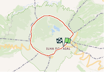
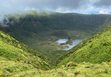
Randonnée A pied de 6,9 km à découvrir à Açores, Inconnu, Cedros. Cette randonnée est proposée par SityTrail - itinéraires balisés pédestres.
Description
Discover the hiking route PRC4FAI Caldeira. View the map and download the GPS track.
Site web: http://trails.visitazores.com/en/trails-azores/faial/caldeira
Localisation
Pays :
Portugal
Région :
Açores
Département/Province :
Inconnu
Commune :
Cedros
Localité :
Unknown
Départ:(Dec)
Départ:(UTM)
351358 ; 4271596 (26S) N.
Commentaires
Randonnées à proximité
![Randonnée A pied Flamengos - Trilho dos Dez Vulcões - Photo](https://media.geolcdn.com/t/375/260/c8ef9ae2-a877-465b-9a91-49d75a53ce18.jpeg&format=jpg&maxdim=2)
![A pied A pied](https://static1.geolcdn.com/sitytour/trail-icons/100.png)
Trilho dos Dez Vulcões
A pied
Moyen
Flamengos,
Açores,
Inconnu,
Portugal
![](/images/other/stat-length.png)
20 km | 30 km-effort
6h 53min
![](https://static1.geolcdn.com/siteimages/upload/files/16400158638029165_repeat_loop_refresh_sync_direction_icon.png)
Non
![Randonnée A pied Praia do Norte - Levada - Photo](https://media.geolcdn.com/t/375/260/c0948bee-32e7-4984-8491-f869ec42074a.jpeg&format=jpg&maxdim=2)
![A pied A pied](https://static1.geolcdn.com/sitytour/trail-icons/100.png)
![Randonnée Marche Flamengos - FAI GR01 : De volcan en volcan, Faial, Azores - Photo](https://media.geolcdn.com/t/375/260/985e57d5-7fee-4e42-948f-8c36ea5eb888.jpeg&format=jpg&maxdim=2)
![Marche Marche](https://static1.geolcdn.com/sitytour/trail-icons/101.png)
FAI GR01 : De volcan en volcan, Faial, Azores
Marche
Difficile
Flamengos,
Açores,
Inconnu,
Portugal
![](/images/other/stat-length.png)
20 km | 30 km-effort
6h 52min
![](https://static1.geolcdn.com/siteimages/upload/files/16400158638029165_repeat_loop_refresh_sync_direction_icon.png)
Non
![Randonnée Marche Cedros - caldeira Faial - Photo](https://media.geolcdn.com/t/375/260/6ada286b-d3e1-4e2c-88fb-a233f16e7cde.jpg&format=jpg&maxdim=2)
![Marche Marche](https://static1.geolcdn.com/sitytour/trail-icons/101.png)
caldeira Faial
Marche
Très facile
Cedros,
Açores,
Inconnu,
Portugal
![](/images/other/stat-length.png)
16,3 km | 23 km-effort
5h 26min
![](https://static1.geolcdn.com/siteimages/upload/files/16400158638029165_repeat_loop_refresh_sync_direction_icon.png)
Non
![Randonnée sport Cedros - Caldera de Faial - Photo](https://media.geolcdn.com/t/375/260/ext.jpg?maxdim=2&url=https%3A%2F%2Fsecurestorage.geolives.com%2Fsitytour%2Ftrail-bg%2Fdefault.jpg)
Caldera de Faial
sport
Très facile
Cedros,
Açores,
Inconnu,
Portugal
![](/images/other/stat-length.png)
10,7 km | 14,7 km-effort
Inconnu
![](https://static1.geolcdn.com/siteimages/upload/files/16400158638029165_repeat_loop_refresh_sync_direction_icon.png)
Non
![Randonnée Marche Cedros - 18/06/24 AÇORES FAIAL 47 CIRCUIT AUTOUR DE LA CALDEIRA - Photo](https://media.geolcdn.com/t/375/260/ext.jpg?maxdim=2&url=https%3A%2F%2Fstatic1.geolcdn.com%2Fsiteimages%2Fupload%2Ffiles%2F1553511878bg_sport_marche.png)
![Marche Marche](https://static1.geolcdn.com/sitytour/trail-icons/101.png)
18/06/24 AÇORES FAIAL 47 CIRCUIT AUTOUR DE LA CALDEIRA
Marche
Moyen
(1)
Cedros,
Açores,
Inconnu,
Portugal
![](/images/other/stat-length.png)
7 km | 10,8 km-effort
2h 27min
![](https://static1.geolcdn.com/siteimages/upload/files/16400158638029165_repeat_loop_refresh_sync_direction_icon.png)
Oui
![Randonnée Marche Flamengos - caldeira faial g et g - Photo](https://media.geolcdn.com/t/375/260/ext.jpg?maxdim=2&url=https%3A%2F%2Fstatic1.geolcdn.com%2Fsiteimages%2Fupload%2Ffiles%2F1553511878bg_sport_marche.png)
![Marche Marche](https://static1.geolcdn.com/sitytour/trail-icons/101.png)
caldeira faial g et g
Marche
Moyen
Flamengos,
Açores,
Inconnu,
Portugal
![](/images/other/stat-length.png)
7 km | 10,5 km-effort
3h 0min
![](https://static1.geolcdn.com/siteimages/upload/files/16400158638029165_repeat_loop_refresh_sync_direction_icon.png)
Oui