![](/images/other/stat-length.png)
![Randonnée A pied Montferland - Nevelhorstpad - Photo](https://media.geolcdn.com/t/1900/400/dev_18706abd-bb65-4663-94cd-1690afa0394a.jpeg&format=pjpeg&maxdim=2)
Nevelhorstpad
SityTrail - itinéraires balisés pédestres
Tous les sentiers balisés d’Europe GUIDE+
![Longueur](/images/other/stat-length.png)
Longueur
4,5 km
![Altitude max](https://static1.geolcdn.com/siteimages/upload/files/1508320355ic_sort_altitude_max_24dp.png)
Altitude max
17 m
![Dénivelé positif](https://static1.geolcdn.com/siteimages/upload/files/1508320355ic_sort_den_pos_24dp.png)
Dénivelé positif
27 m
![Km-Effort](/images/other/stat-length.png)
Km-Effort
4,9 km
![Altitude min](https://static1.geolcdn.com/siteimages/upload/files/1508320355ic_sort_altitude_min_24dp.png)
Altitude min
8 m
![Dénivelé négatif](https://static1.geolcdn.com/siteimages/upload/files/1508320355ic_sort_den_neg_24dp.png)
Dénivelé négatif
27 m
![Boucle](https://static1.geolcdn.com/siteimages/upload/files/16400158638029165_repeat_loop_refresh_sync_direction_icon.png)
Boucle
Oui
Balise
Date de création :
2022-02-14 14:21:52.144
Dernière modification :
2022-02-14 14:21:52.144
![A pied](https://static1.geolcdn.com/sitytour/trail-icons/100.png)
1h06
Difficulté : Facile
![Scannez ce code QR pour ouvrir la randonnée dans l'application SityTrail](https://capi.geolives.com/qq0zvz2zws4bq2lad0pu/sitytour/trails/3108314/qr.png?size=200)
Application GPS de randonnée GRATUITE
À propos
Randonnée A pied de 4,5 km à découvrir à Gueldre, Inconnu, Montferland. Cette randonnée est proposée par SityTrail - itinéraires balisés pédestres.
Description
blauwe pijltjes
Symbole: blue arrow with footprint
Site web: http://www.recreatieschap.nl/Download.aspx?File=885
Localisation
Pays :
Pays-Bas
Région :
Gueldre
Département/Province :
Inconnu
Commune :
Montferland
Localité :
Unknown
Départ:(Dec)
Départ:(UTM)
301848 ; 5758323 (32U) N.
Commentaires
Randonnées à proximité
![Randonnée A pied Montferland - Laarzenpad - Photo](https://media.geolcdn.com/t/375/260/dev_18706abd-bb65-4663-94cd-1690afa0394a.jpeg&format=jpg&maxdim=2)
![A pied A pied](https://static1.geolcdn.com/sitytour/trail-icons/100.png)
Laarzenpad
A pied
Facile
Montferland,
Gueldre,
Inconnu,
Pays-Bas
![](/images/other/stat-length.png)
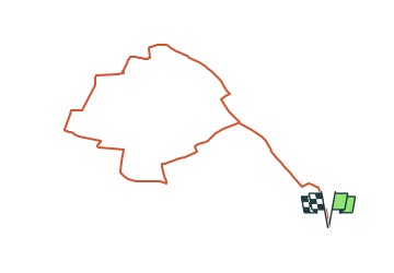
6,3 km | 6,9 km-effort
1h 34min
![](https://static1.geolcdn.com/siteimages/upload/files/16400158638029165_repeat_loop_refresh_sync_direction_icon.png)
Oui
![Randonnée A pied Montferland - Liemers Knooppad 6 - Photo](https://media.geolcdn.com/t/375/260/dev_b2ad50d1-04eb-423f-928a-8ae9dca5c1cf.jpeg&format=jpg&maxdim=2)
![A pied A pied](https://static1.geolcdn.com/sitytour/trail-icons/100.png)
Liemers Knooppad 6
A pied
Facile
Montferland,
Gueldre,
Inconnu,
Pays-Bas
![](/images/other/stat-length.png)
9,4 km | 10,4 km-effort
2h 21min
![](https://static1.geolcdn.com/siteimages/upload/files/16400158638029165_repeat_loop_refresh_sync_direction_icon.png)
Non
![Randonnée Vélo Zevenaar - f-gelderland-grenslandroute - Photo](https://media.geolcdn.com/t/375/260/ext.jpg?maxdim=2&url=https%3A%2F%2Fstatic1.geolcdn.com%2Fsiteimages%2Fupload%2Ffiles%2F1524743154velo.jpg)
![Vélo Vélo](https://static1.geolcdn.com/sitytour/trail-icons/200.png)
f-gelderland-grenslandroute
Vélo
Très facile
Zevenaar,
Gueldre,
Inconnu,
Pays-Bas
![](/images/other/stat-length.png)
38 km | 42 km-effort
Inconnu
![](https://static1.geolcdn.com/siteimages/upload/files/16400158638029165_repeat_loop_refresh_sync_direction_icon.png)
Non
![Randonnée Marche Zevenaar - w-gelderland-rijnstrangenroute - Photo](https://media.geolcdn.com/t/375/260/ext.jpg?maxdim=2&url=https%3A%2F%2Fstatic1.geolcdn.com%2Fsiteimages%2Fupload%2Ffiles%2F1553511878bg_sport_marche.png)
![Marche Marche](https://static1.geolcdn.com/sitytour/trail-icons/101.png)
w-gelderland-rijnstrangenroute
Marche
Très facile
Zevenaar,
Gueldre,
Inconnu,
Pays-Bas
![](/images/other/stat-length.png)
15,1 km | 15,9 km-effort
Inconnu
![](https://static1.geolcdn.com/siteimages/upload/files/16400158638029165_repeat_loop_refresh_sync_direction_icon.png)
Non