![](/images/other/stat-length.png)
![Randonnée A pied Kloten - Flughafen-Rundweg - Photo](https://media.geolcdn.com/t/1900/400/ext.pjpeg?maxdim=2&url=https%3A%2F%2Fmedia.geolcdn.com%2Ff%2Ff73e2ef4-2b1c-4bcc-b8fb-83af47c7493a.jpeg)
Flughafen-Rundweg
SityTrail - itinéraires balisés pédestres
Tous les sentiers balisés d’Europe PRO
![Longueur](/images/other/stat-length.png)
Longueur
16,6 km
![Altitude max](https://static1.geolcdn.com/siteimages/upload/files/1508320355ic_sort_altitude_max_24dp.png)
Altitude max
448 m
![Dénivelé positif](https://static1.geolcdn.com/siteimages/upload/files/1508320355ic_sort_den_pos_24dp.png)
Dénivelé positif
129 m
![Km-Effort](/images/other/stat-length.png)
Km-Effort
18,3 km
![Altitude min](https://static1.geolcdn.com/siteimages/upload/files/1508320355ic_sort_altitude_min_24dp.png)
Altitude min
415 m
![Dénivelé négatif](https://static1.geolcdn.com/siteimages/upload/files/1508320355ic_sort_den_neg_24dp.png)
Dénivelé négatif
126 m
![Boucle](https://static1.geolcdn.com/siteimages/upload/files/16400158638029165_repeat_loop_refresh_sync_direction_icon.png)
Boucle
Oui
Balise
Date de création :
2022-02-14 09:05:18.012
Dernière modification :
2022-02-14 09:05:18.012
![A pied](https://static1.geolcdn.com/sitytour/trail-icons/100.png)
4h09
Difficulté : Facile
![Scannez ce code QR pour ouvrir la randonnée dans l'application SityTrail](https://capi.geolives.com/qq0zvz2zws4bq2lad0pu/sitytour/trails/3107422/qr.png?size=200)
Application GPS de randonnée GRATUITE
À propos
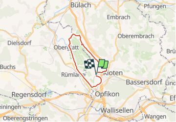
Randonnée A pied de 16,6 km à découvrir à Zurich, Bezirk Bülach, Kloten. Cette randonnée est proposée par SityTrail - itinéraires balisés pédestres.
Description
Randonnée créée par Zürcher Wanderwege ZAW.
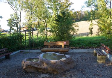
Rollstuhlwanderung
Symbole: weisser Rollstuhl unten links, weisse 892 oben rechts auf grünem Grund und rotem Unterstrich
Localisation
Pays :
Suisse
Région :
Zurich
Département/Province :
Bezirk Bülach
Commune :
Kloten
Localité :
Unknown
Départ:(Dec)
Départ:(UTM)
467078 ; 5255279 (32T) N.
Commentaires
Randonnées à proximité
![Randonnée A pied Oberembrach - Oberembrach - Breite - Photo](https://media.geolcdn.com/t/375/260/ext.jpg?maxdim=2&url=https%3A%2F%2Fmedia.geolcdn.com%2Ff%2Fa7062106-b5f2-4b38-be3a-60e2fa11e1c8.jpeg)
![A pied A pied](https://static1.geolcdn.com/sitytour/trail-icons/100.png)
Oberembrach - Breite
A pied
Facile
Oberembrach,
Zurich,
Bezirk Bülach,
Suisse
![](/images/other/stat-length.png)
6,8 km | 9,3 km-effort
2h 7min
![](https://static1.geolcdn.com/siteimages/upload/files/16400158638029165_repeat_loop_refresh_sync_direction_icon.png)
Non
![Randonnée A pied Kloten - Kloten - Winterthur Töss - Photo](https://media.geolcdn.com/t/375/260/ext.jpg?maxdim=2&url=https%3A%2F%2Fmedia.geolcdn.com%2Ff%2Ffc9b7936-bafc-410d-a024-a7aa38ed53d8.jpeg)
![A pied A pied](https://static1.geolcdn.com/sitytour/trail-icons/100.png)
Kloten - Winterthur Töss
A pied
Facile
Kloten,
Zurich,
Bezirk Bülach,
Suisse
![](/images/other/stat-length.png)
14 km | 19,4 km-effort
4h 23min
![](https://static1.geolcdn.com/siteimages/upload/files/16400158638029165_repeat_loop_refresh_sync_direction_icon.png)
Non
![Randonnée A pied Kloten - Kloten - Pfungen - Photo](https://media.geolcdn.com/t/375/260/ext.jpg?maxdim=2&url=https%3A%2F%2Fmedia.geolcdn.com%2Ff%2F264f6337-3574-4ad2-a1a3-6195a173578f.jpeg)
![A pied A pied](https://static1.geolcdn.com/sitytour/trail-icons/100.png)
Kloten - Pfungen
A pied
Facile
Kloten,
Zurich,
Bezirk Bülach,
Suisse
![](/images/other/stat-length.png)
13,2 km | 18,1 km-effort
4h 6min
![](https://static1.geolcdn.com/siteimages/upload/files/16400158638029165_repeat_loop_refresh_sync_direction_icon.png)
Non
![Randonnée A pied Oberembrach - Oberembrach - Freienstein - Photo](https://media.geolcdn.com/t/375/260/ext.jpg?maxdim=2&url=https%3A%2F%2Fmedia.geolcdn.com%2Ff%2F10b2ec12-4973-4ef0-85c0-d35c9f6590b4.jpeg)
![A pied A pied](https://static1.geolcdn.com/sitytour/trail-icons/100.png)
Oberembrach - Freienstein
A pied
Facile
Oberembrach,
Zurich,
Bezirk Bülach,
Suisse
![](/images/other/stat-length.png)
9,8 km | 13,3 km-effort
3h 1min
![](https://static1.geolcdn.com/siteimages/upload/files/16400158638029165_repeat_loop_refresh_sync_direction_icon.png)
Non
![Randonnée A pied Kloten - Kloten - Bülach - Photo](https://media.geolcdn.com/t/375/260/ext.jpg?maxdim=2&url=https%3A%2F%2Fmedia.geolcdn.com%2Ff%2F02b8d393-a0f3-44a1-8b6f-734f105fb091.jpeg)
![A pied A pied](https://static1.geolcdn.com/sitytour/trail-icons/100.png)
Kloten - Bülach
A pied
Facile
Kloten,
Zurich,
Bezirk Bülach,
Suisse
![](/images/other/stat-length.png)
14,4 km | 17,4 km-effort
3h 57min
![](https://static1.geolcdn.com/siteimages/upload/files/16400158638029165_repeat_loop_refresh_sync_direction_icon.png)
Non
![Randonnée A pied Embrach - Husacher - Winkel Seeb - Photo](https://media.geolcdn.com/t/375/260/ext.jpg?maxdim=2&url=https%3A%2F%2Fmedia.geolcdn.com%2Ff%2F5c4e2fb5-0a98-41e0-92f3-4503633811d6.jpeg)
![A pied A pied](https://static1.geolcdn.com/sitytour/trail-icons/100.png)
Husacher - Winkel Seeb
A pied
Facile
Embrach,
Zurich,
Bezirk Bülach,
Suisse
![](/images/other/stat-length.png)
4,2 km | 5,4 km-effort
1h 13min
![](https://static1.geolcdn.com/siteimages/upload/files/16400158638029165_repeat_loop_refresh_sync_direction_icon.png)
Non
![Randonnée A pied Kloten - Kloten - Homberg - Photo](https://media.geolcdn.com/t/375/260/ext.jpg?maxdim=2&url=https%3A%2F%2Fmedia.geolcdn.com%2Ff%2F02b8d393-a0f3-44a1-8b6f-734f105fb091.jpeg)
![A pied A pied](https://static1.geolcdn.com/sitytour/trail-icons/100.png)
Kloten - Homberg
A pied
Facile
Kloten,
Zurich,
Bezirk Bülach,
Suisse
![](/images/other/stat-length.png)
4 km | 4,8 km-effort
1h 4min
![](https://static1.geolcdn.com/siteimages/upload/files/16400158638029165_repeat_loop_refresh_sync_direction_icon.png)
Non
![Randonnée A pied Niederglatt - Niederglatt - Station Glattfelden - Photo](https://media.geolcdn.com/t/375/260/ext.jpg?maxdim=2&url=https%3A%2F%2Fmedia.geolcdn.com%2Ff%2F693bff4b-ad3d-4b66-a5e5-82565fdc79d3.jpeg)
![A pied A pied](https://static1.geolcdn.com/sitytour/trail-icons/100.png)
Niederglatt - Station Glattfelden
A pied
Facile
Niederglatt,
Zurich,
Bezirk Dielsdorf,
Suisse
![](/images/other/stat-length.png)
10,6 km | 12,4 km-effort
2h 48min
![](https://static1.geolcdn.com/siteimages/upload/files/16400158638029165_repeat_loop_refresh_sync_direction_icon.png)
Non
![Randonnée A pied Rümlang - Rümlang - Niederglatt - Photo](https://media.geolcdn.com/t/375/260/ext.jpg?maxdim=2&url=https%3A%2F%2Fmedia.geolcdn.com%2Ff%2F71d0322e-c513-49ab-8343-5d82aa7d0ce2.jpeg)
![A pied A pied](https://static1.geolcdn.com/sitytour/trail-icons/100.png)
Rümlang - Niederglatt
A pied
Facile
Rümlang,
Zurich,
Bezirk Dielsdorf,
Suisse
![](/images/other/stat-length.png)
9 km | 10,6 km-effort
2h 24min
![](https://static1.geolcdn.com/siteimages/upload/files/16400158638029165_repeat_loop_refresh_sync_direction_icon.png)
Non